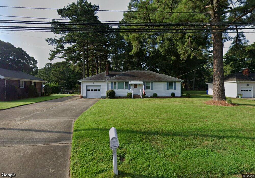
205 Cedar Rd Chesapeake, VA 23322
Great Bridge NeighborhoodEstimated Value: $327,000 - $380,000
3
Beds
1
Bath
1,107
Sq Ft
$320/Sq Ft
Est. Value
About This Home
This home is located at 205 Cedar Rd, Chesapeake, VA 23322 and is currently estimated at $354,193, approximately $319 per square foot. 205 Cedar Rd is a home located in Chesapeake City with nearby schools including Great Bridge Primary School, Great Bridge Intermediate School, and Great Bridge Middle School.
Ownership History
Date
Name
Owned For
Owner Type
Purchase Details
Closed on
Oct 21, 2024
Sold by
Marie N Halstead Living Trust and Cochran Karen H
Bought by
Halstead Marie N
Current Estimated Value
Home Financials for this Owner
Home Financials are based on the most recent Mortgage that was taken out on this home.
Original Mortgage
$487,500
Outstanding Balance
$397,568
Interest Rate
6.08%
Estimated Equity
-$43,375
Create a Home Valuation Report for This Property
The Home Valuation Report is an in-depth analysis detailing your home's value as well as a comparison with similar homes in the area
Home Values in the Area
Average Home Value in this Area
Purchase History
| Date | Buyer | Sale Price | Title Company |
|---|---|---|---|
| Halstead Marie N | -- | Westcor Land Title | |
| Halstead Marie N | -- | Westcor Land Title |
Source: Public Records
Mortgage History
| Date | Status | Borrower | Loan Amount |
|---|---|---|---|
| Open | Halstead Marie N | $487,500 | |
| Closed | Halstead Marie N | $487,500 | |
| Closed | Halstead Marie N | $487,500 |
Source: Public Records
Tax History Compared to Growth
Tax History
| Year | Tax Paid | Tax Assessment Tax Assessment Total Assessment is a certain percentage of the fair market value that is determined by local assessors to be the total taxable value of land and additions on the property. | Land | Improvement |
|---|---|---|---|---|
| 2025 | $2,859 | $299,700 | $180,000 | $119,700 |
| 2024 | $2,859 | $283,100 | $170,000 | $113,100 |
| 2023 | $2,502 | $268,000 | $160,000 | $108,000 |
| 2022 | $2,514 | $248,900 | $140,000 | $108,900 |
| 2021 | $2,272 | $216,400 | $120,000 | $96,400 |
| 2020 | $2,136 | $203,400 | $110,000 | $93,400 |
| 2019 | $2,119 | $201,800 | $110,000 | $91,800 |
| 2018 | $2,204 | $209,900 | $120,000 | $89,900 |
| 2017 | $2,204 | $209,900 | $120,000 | $89,900 |
| 2016 | $2,066 | $196,800 | $112,000 | $84,800 |
| 2015 | $2,066 | $196,800 | $112,000 | $84,800 |
| 2014 | $2,066 | $196,800 | $112,000 | $84,800 |
Source: Public Records
Map
Nearby Homes
- 209 Britwell Dr
- 416 Woodberry Dr
- 169 Harbor Watch Dr
- 500 Deal Island Ct
- 101 Stadium Dr
- 513 E Lake Cir
- 533 E Lake Cir
- 712 Magnum Rd
- 822 W Lake Cir
- 520 Foxgate Quarter
- 640 W Lake Cir
- 405 Briarwood Ct
- 535 Parker Rd
- 745 S Lake Cir
- 436 Butterfly Dr
- 701 Pinecliffe Dr
- 352 Hurdle Dr
- 716 Johnstown Rd
- 632 Sedgefield Ct
- 536 Scarborough Dr