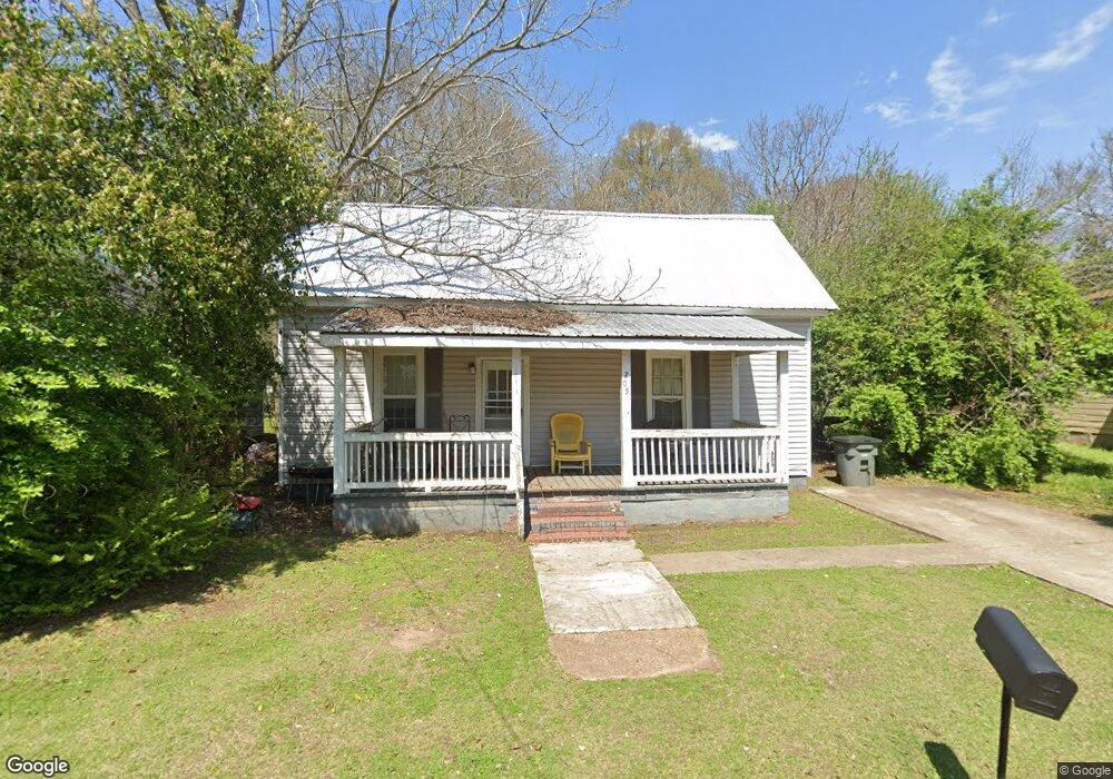
205 de Groat St Lagrange, GA 30241
Estimated Value: $79,000 - $102,000
2
Beds
1
Bath
871
Sq Ft
$103/Sq Ft
Est. Value
About This Home
This home is located at 205 de Groat St, Lagrange, GA 30241 and is currently estimated at $89,600, approximately $102 per square foot. 205 de Groat St is a home located in Troup County with nearby schools including Franklin Forest Elementary School, Hollis Hand Elementary School, and Ethel W. Kight Elementary School.
Ownership History
Date
Name
Owned For
Owner Type
Purchase Details
Closed on
Mar 29, 2019
Sold by
Blackwell Realty And Land Holding Co Llc
Bought by
Yingling Property Management Llc
Current Estimated Value
Purchase Details
Closed on
Nov 17, 2003
Sold by
Lamar Mckeen
Bought by
Blackwells Realty And Landhold
Purchase Details
Closed on
Mar 20, 1987
Bought by
Lamar Mckeen
Purchase Details
Closed on
Sep 21, 1981
Purchase Details
Closed on
Jan 1, 1956
Create a Home Valuation Report for This Property
The Home Valuation Report is an in-depth analysis detailing your home's value as well as a comparison with similar homes in the area
Home Values in the Area
Average Home Value in this Area
Purchase History
| Date | Buyer | Sale Price | Title Company |
|---|---|---|---|
| Yingling Property Management Llc | $112,000 | -- | |
| Blackwells Realty And Landhold | $16,500 | -- | |
| Lamar Mckeen | $12,900 | -- | |
| -- | -- | -- | |
| -- | -- | -- |
Source: Public Records
Tax History Compared to Growth
Tax History
| Year | Tax Paid | Tax Assessment Tax Assessment Total Assessment is a certain percentage of the fair market value that is determined by local assessors to be the total taxable value of land and additions on the property. | Land | Improvement |
|---|---|---|---|---|
| 2024 | $621 | $22,760 | $3,040 | $19,720 |
| 2023 | $496 | $18,200 | $3,040 | $15,160 |
| 2022 | $483 | $17,320 | $3,040 | $14,280 |
| 2021 | $480 | $15,920 | $3,040 | $12,880 |
| 2020 | $450 | $15,920 | $3,040 | $12,880 |
| 2019 | $442 | $14,640 | $3,040 | $11,600 |
| 2018 | $408 | $13,512 | $1,912 | $11,600 |
| 2017 | $408 | $13,512 | $1,912 | $11,600 |
| 2016 | $396 | $13,140 | $1,912 | $11,228 |
| 2015 | $397 | $13,140 | $1,912 | $11,228 |
| 2014 | $380 | $12,549 | $1,912 | $10,637 |
| 2013 | -- | $13,522 | $1,912 | $11,610 |
Source: Public Records
Map
Nearby Homes
- 121 de Groat St
- 621 Arthur St
- 902 Georgia Ave
- 906 Georgia Ave
- 131 Foch St
- 618 S Harlem Cir
- 616 S Harlem Cir
- 608 S Harlem Cir
- 606 S Harlem Cir
- 600 S Harlem Cir
- 801 Hines St
- 228 E Render St
- 706 N Harlem Cir
- 208 Render St
- 117 Belk St
- LOT 58 Belk St
- 119 Belk St
- LOT 65 Belk St
- LOT 66 Belk St
- 600,606,608,616 S Harlem
- 205 de Groat St
- 203 de Groat St
- 207 de Groat St
- 201 de Groat St
- 704 de Groat St
- 702 de Groat St
- 402 Dixie St
- 706 de Groat St
- 209 de Groat St
- 700 de Groat St
- 0 Dixie St Unit 8669672
- 404 Dixie St
- 211 de Groat St
- 710 de Groat St
- 705 Chattahoochee St
- 703 Chattahoochee St
- 707 Chattahoochee St
- 100 de Groat Aly
- 701 Chattahoochee St
- 709 Chattahoochee St