Estimated Value: $140,000 - $169,000
Studio
--
Bath
1,902
Sq Ft
$83/Sq Ft
Est. Value
About This Home
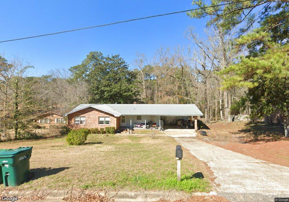
This home is located at 205 Deerpath St, Ozark, AL 36360 and is currently estimated at $158,237, approximately $83 per square foot. 205 Deerpath St is a home located in Dale County with nearby schools including Lisenby Primary School, Mixon Intermediate School, and D. A. Smith Middle School.
Ownership History
Date
Name
Owned For
Owner Type
Purchase Details
Closed on
Nov 10, 2021
Sold by
Boldin Charles R and Hagedorn Amelia
Bought by
English Jonathan
Current Estimated Value
Home Financials for this Owner
Home Financials are based on the most recent Mortgage that was taken out on this home.
Original Mortgage
$130,000
Outstanding Balance
$119,156
Interest Rate
3.01%
Mortgage Type
VA
Estimated Equity
$39,081
Purchase Details
Closed on
May 31, 2016
Sold by
Beekman Andrew J
Bought by
Boldin Charles R and Hagedorn Amelia
Create a Home Valuation Report for This Property
The Home Valuation Report is an in-depth analysis detailing your home's value as well as a comparison with similar homes in the area
Purchase History
| Date | Buyer | Sale Price | Title Company |
|---|---|---|---|
| English Jonathan | $130,000 | None Available | |
| Boldin Charles R | -- | -- |
Source: Public Records
Mortgage History
| Date | Status | Borrower | Loan Amount |
|---|---|---|---|
| Open | English Jonathan | $130,000 |
Source: Public Records
Tax History
| Year | Tax Paid | Tax Assessment Tax Assessment Total Assessment is a certain percentage of the fair market value that is determined by local assessors to be the total taxable value of land and additions on the property. | Land | Improvement |
|---|---|---|---|---|
| 2024 | $891 | $16,500 | $540 | $15,960 |
| 2023 | $833 | $15,280 | $540 | $14,740 |
| 2022 | $944 | $18,700 | $7,700 | $11,000 |
| 2021 | $879 | $17,400 | $1,060 | $16,340 |
| 2020 | $937 | $18,560 | $1,060 | $17,500 |
| 2019 | $937 | $18,560 | $1,060 | $17,500 |
| 2018 | $880 | $17,420 | $1,060 | $16,360 |
| 2017 | $134 | $2,660 | $1,060 | $1,600 |
| 2016 | $129 | $2,560 | $1,060 | $1,500 |
| 2015 | $129 | $2,560 | $1,060 | $1,500 |
| 2014 | $128 | $2,540 | $1,060 | $1,480 |
| 2013 | $127 | $2,540 | $1,060 | $1,480 |
Source: Public Records
Map
Nearby Homes
- 299 Buena Vista Dr
- 0 Del Rio Terrace
- 0 Briar Cliff Dr Lot 1 Blk D
- 0 Briar Cliff Rd Lot 5 Bk E
- Short Pine Ave
- 166 Garner Dr
- LOT 2 Sandy Hills Ct
- 13.35 Acres U S 231
- 1.5 Acres U S 231
- 4.3 Acres U S 231
- 1.144 Acres S Highway 231
- 167 Oakdale Dr
- 204 Dixie Dr
- 0000 Magnolia St
- 566 Newton Ave
- 876 Camilla Ave
- 275 White Ave
- 121 Charles St
- 704 Camilla Ave
- 0 Deese Rd Unit TRACT A
- 261 Deerpath St
- 202 Deerpath St
- 241 Deerpath St
- 221 Deerpath St
- 242 Deerpath St
- 242 Deerpath St
- 179 Berkshire Dr
- 196 Deerpath St
- 199 Deerpath St
- 398 Deese Rd
- 153 Berkshire Dr
- 418 Deese Rd
- 102 Deerpath St
- 166 Deerpath St
- 110 Deerpath St
- 123 Berkshire Dr
- 148 Berkshire Dr
- 105 Deerpath St
- 446 Deese Rd
- 446 Deese Rd
Your Personal Tour Guide
Ask me questions while you tour the home.