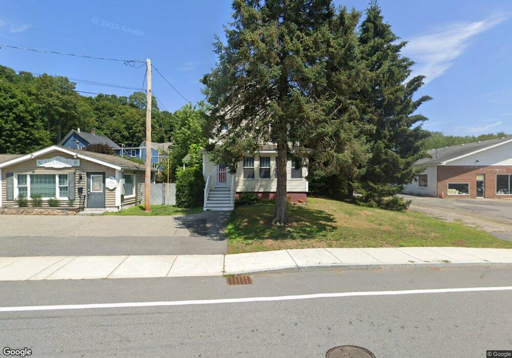
205 Elm St Amesbury, MA 01913
Estimated Value: $619,351 - $690,000
3
Beds
1
Bath
1,931
Sq Ft
$336/Sq Ft
Est. Value
About This Home
This home is located at 205 Elm St, Amesbury, MA 01913 and is currently estimated at $649,588, approximately $336 per square foot. 205 Elm St is a home located in Essex County with nearby schools including Amesbury High School and Amesbury Seventh-Day Adventist School.
Ownership History
Date
Name
Owned For
Owner Type
Purchase Details
Closed on
Feb 25, 2000
Sold by
Thornell George P and Thornell Carol
Bought by
Obrien Michael S
Current Estimated Value
Purchase Details
Closed on
Jun 27, 1991
Sold by
Leathers Everett F and Leathers Barbara
Bought by
Thornell George P and Thornell Carol A
Create a Home Valuation Report for This Property
The Home Valuation Report is an in-depth analysis detailing your home's value as well as a comparison with similar homes in the area
Home Values in the Area
Average Home Value in this Area
Purchase History
| Date | Buyer | Sale Price | Title Company |
|---|---|---|---|
| Obrien Michael S | $155,000 | -- | |
| Thornell George P | $131,300 | -- |
Source: Public Records
Mortgage History
| Date | Status | Borrower | Loan Amount |
|---|---|---|---|
| Open | Thornell George P | $21,500 | |
| Open | Thornell George P | $215,000 |
Source: Public Records
Tax History Compared to Growth
Tax History
| Year | Tax Paid | Tax Assessment Tax Assessment Total Assessment is a certain percentage of the fair market value that is determined by local assessors to be the total taxable value of land and additions on the property. | Land | Improvement |
|---|---|---|---|---|
| 2025 | $7,679 | $501,900 | $214,700 | $287,200 |
| 2024 | $7,241 | $463,000 | $202,500 | $260,500 |
| 2023 | $7,134 | $436,600 | $176,100 | $260,500 |
| 2022 | $6,489 | $366,800 | $153,100 | $213,700 |
| 2021 | $6,382 | $349,700 | $118,300 | $231,400 |
| 2020 | $5,709 | $332,300 | $113,700 | $218,600 |
| 2019 | $5,676 | $309,000 | $113,700 | $195,300 |
| 2018 | $5,454 | $287,200 | $108,400 | $178,800 |
| 2017 | $5,181 | $259,700 | $108,400 | $151,300 |
| 2016 | $5,127 | $252,800 | $108,400 | $144,400 |
| 2015 | $5,022 | $244,500 | $108,400 | $136,100 |
| 2014 | $4,811 | $229,400 | $108,400 | $121,000 |
Source: Public Records
Map
Nearby Homes
- 204 Elm St
- 1 Democracy Dr
- 270 Elm St
- 118 Elm St
- 47 Macy St
- 45 Macy St Unit b101
- 5 Richs Ct Unit 3
- 97 Elm St
- 82 Monroe St
- 4 Clark St
- 25 Cedar St Unit 4
- 25 Cedar St Unit 7
- 3 Birchwood Point Unit 202
- 3 Laurel Place
- 382 Main St
- 4 Greenwood St
- 7 Birchwood Pointe Unit 101
- 356 Main St
- 37 Millyard Unit 204
- 11 1/2 Sanborn Terrace