Estimated Value: $239,000 - $306,000
3
Beds
2
Baths
1,442
Sq Ft
$192/Sq Ft
Est. Value
About This Home
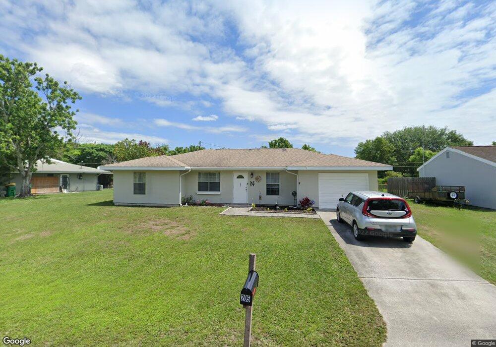
This home is located at 205 Manth Ave, Cocoa, FL 32927 and is currently estimated at $276,277, approximately $191 per square foot. 205 Manth Ave is a home located in Brevard County with nearby schools including Atlantis Elementary School, Space Coast Junior/Senior High School, and East Atlantic Prep of Brevard County.
Ownership History
Date
Name
Owned For
Owner Type
Purchase Details
Closed on
Jan 14, 2026
Sold by
Heiden James S and Heiden Cindy L
Bought by
Heiden
Current Estimated Value
Purchase Details
Closed on
Jan 22, 2010
Sold by
Strand Robert D and Strand Nancy L
Bought by
Heiden James S and Heiden Cindy L
Purchase Details
Closed on
Mar 23, 1994
Sold by
Johnson Bruce E and Johnson Jody A
Bought by
Strand Robert D and Strand Nancy L
Home Financials for this Owner
Home Financials are based on the most recent Mortgage that was taken out on this home.
Original Mortgage
$46,200
Interest Rate
7.2%
Create a Home Valuation Report for This Property
The Home Valuation Report is an in-depth analysis detailing your home's value as well as a comparison with similar homes in the area
Home Values in the Area
Average Home Value in this Area
Purchase History
| Date | Buyer | Sale Price | Title Company |
|---|---|---|---|
| Heiden | $100 | None Listed On Document | |
| Heiden James S | -- | None Available | |
| Strand Robert D | $66,000 | -- |
Source: Public Records
Mortgage History
| Date | Status | Borrower | Loan Amount |
|---|---|---|---|
| Previous Owner | Strand Robert D | $46,200 |
Source: Public Records
Tax History
| Year | Tax Paid | Tax Assessment Tax Assessment Total Assessment is a certain percentage of the fair market value that is determined by local assessors to be the total taxable value of land and additions on the property. | Land | Improvement |
|---|---|---|---|---|
| 2025 | $3,019 | $226,870 | -- | -- |
| 2024 | $2,922 | $228,980 | -- | -- |
| 2023 | $2,922 | $221,930 | $0 | $0 |
| 2022 | $2,517 | $190,710 | $0 | $0 |
| 2021 | $2,273 | $142,310 | $42,000 | $100,310 |
| 2020 | $2,089 | $128,460 | $40,000 | $88,460 |
| 2019 | $1,974 | $123,430 | $35,000 | $88,430 |
| 2018 | $1,872 | $112,010 | $27,000 | $85,010 |
| 2017 | $1,779 | $100,180 | $24,000 | $76,180 |
| 2016 | $1,650 | $82,810 | $18,000 | $64,810 |
| 2015 | $1,571 | $64,570 | $15,000 | $49,570 |
| 2014 | $1,440 | $58,700 | $11,000 | $47,700 |
Source: Public Records
Map
Nearby Homes
- 985 Tope St
- 7470 N Highway 1 Unit 101
- 7400 N Highway 1 Unit 105
- 7350 N Highway 1 Unit 201
- 7330 N Highway 1 Unit 206
- 7310 N Highway 1 Unit 201
- 7300 N Highway 1 Unit 104
- 873 Dunbar St
- 865 Dunbar St
- 0 Kanawha St
- 000 Arabella Ln
- 7240 N Highway 1 Unit 106
- 7170 N Highway 1 Unit 103
- 7160 N Highway 1 Unit 204
- 361 Payne Ave
- 977 Poinsetta St
- 1014 Illinois Rd
- 414 Oakridge Ave
- 1029 Illinois Rd
- 1040 Jersey St
Your Personal Tour Guide
Ask me questions while you tour the home.