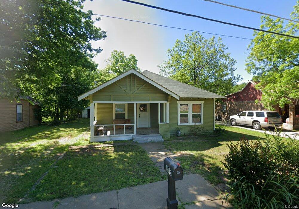
205 Monroe St Cleburne, TX 76033
Estimated Value: $181,294 - $257,000
3
Beds
1
Bath
1,284
Sq Ft
$159/Sq Ft
Est. Value
About This Home
This home is located at 205 Monroe St, Cleburne, TX 76033 and is currently estimated at $203,824, approximately $158 per square foot. 205 Monroe St is a home located in Johnson County with nearby schools including Cooke Elementary School, A.D. Wheat Middle School, and Cleburne High School.
Ownership History
Date
Name
Owned For
Owner Type
Purchase Details
Closed on
Aug 29, 2024
Sold by
Hooper Mark and Hooper Shamarie
Bought by
Clanton Uel Scot and Clanton Grace
Current Estimated Value
Home Financials for this Owner
Home Financials are based on the most recent Mortgage that was taken out on this home.
Original Mortgage
$145,000
Outstanding Balance
$137,817
Interest Rate
6.05%
Mortgage Type
New Conventional
Estimated Equity
$66,007
Purchase Details
Closed on
Jun 5, 2023
Sold by
Leonard Marian Luanne
Bought by
Hooper Mark and Hooper Shamarie
Purchase Details
Closed on
Oct 25, 2022
Sold by
Walker Marian Willene
Bought by
Walker Marian Willene Mort
Create a Home Valuation Report for This Property
The Home Valuation Report is an in-depth analysis detailing your home's value as well as a comparison with similar homes in the area
Home Values in the Area
Average Home Value in this Area
Purchase History
| Date | Buyer | Sale Price | Title Company |
|---|---|---|---|
| Clanton Uel Scot | -- | Stewart Title | |
| Hooper Mark | -- | Truly Title | |
| Walker Marian Willene Mort | -- | -- |
Source: Public Records
Mortgage History
| Date | Status | Borrower | Loan Amount |
|---|---|---|---|
| Open | Clanton Uel Scot | $145,000 |
Source: Public Records
Tax History
| Year | Tax Paid | Tax Assessment Tax Assessment Total Assessment is a certain percentage of the fair market value that is determined by local assessors to be the total taxable value of land and additions on the property. | Land | Improvement |
|---|---|---|---|---|
| 2025 | $1,907 | $85,516 | $38,500 | $47,016 |
| 2024 | $1,907 | $85,516 | $38,500 | $47,016 |
| 2023 | $267 | $85,516 | $38,500 | $47,016 |
| 2022 | $1,786 | $76,516 | $29,500 | $47,016 |
| 2021 | $1,692 | $76,516 | $29,500 | $47,016 |
| 2020 | $1,634 | $67,016 | $20,000 | $47,016 |
| 2019 | $1,584 | $67,016 | $20,000 | $47,016 |
| 2018 | $1,441 | $50,878 | $16,500 | $34,378 |
| 2017 | $1,304 | $50,878 | $16,500 | $34,378 |
| 2016 | $1,186 | $40,275 | $13,500 | $26,775 |
| 2015 | $342 | $40,275 | $13,500 | $26,775 |
| 2014 | $342 | $40,275 | $13,500 | $26,775 |
Source: Public Records
Map
Nearby Homes
- 104 Dixon St
- 511 W Wilson St
- 108 Monroe St
- 618 Granbury St
- 1001 Princeton Place
- 311 N Pendell Ave
- 206 N Holloway St
- 318 W Willingham St
- 1111 N Douglas Ave Unit Lot 2
- 1016 Sheridan Ln
- 910 Baird St
- 1108 Davis St
- 1022 Princeton Place
- 226 W Willingham St
- 217 W Heard St
- 1301 N Douglas Ave
- 1307 Joslin St
- 1105 Poindexter Ave
- 114 S Field St
- 509 N Buffalo Ave
- 203 Monroe St
- 207 Monroe St
- 209 Monroe St
- 105 Madison St
- 103 Madison St
- 524 W Wilson St
- 526 W Wilson St
- 201 Madison St
- 217 Monroe St
- 528 W Wilson St
- 101 Madison St
- 530 W Wilson St
- 203 Madison St Unit A
- 203 Madison St Unit A & B
- 203 Madison St
- 203 Madison St Unit B
- 106 Madison St
- 106 Dixon St
- 219 Monroe St
- 104 Madison St
Your Personal Tour Guide
Ask me questions while you tour the home.