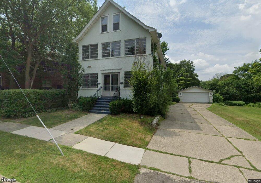
205 Muir Rd Unit Bldg-Unit Grosse Pointe Farms, MI 48236
Estimated Value: $411,000 - $620,000
--
Bed
2
Baths
2,431
Sq Ft
$196/Sq Ft
Est. Value
About This Home
This home is located at 205 Muir Rd Unit Bldg-Unit, Grosse Pointe Farms, MI 48236 and is currently estimated at $477,307, approximately $196 per square foot. 205 Muir Rd Unit Bldg-Unit is a home located in Wayne County with nearby schools including Richard Elementary School, Brownell Middle School, and Grosse Pointe South High School.
Ownership History
Date
Name
Owned For
Owner Type
Purchase Details
Closed on
Apr 20, 2018
Sold by
Ahee Margaret M and Ahee William S
Bought by
Oxholm Jose
Current Estimated Value
Home Financials for this Owner
Home Financials are based on the most recent Mortgage that was taken out on this home.
Original Mortgage
$203,500
Outstanding Balance
$174,721
Interest Rate
4.37%
Mortgage Type
FHA
Estimated Equity
$302,586
Create a Home Valuation Report for This Property
The Home Valuation Report is an in-depth analysis detailing your home's value as well as a comparison with similar homes in the area
Home Values in the Area
Average Home Value in this Area
Purchase History
| Date | Buyer | Sale Price | Title Company |
|---|---|---|---|
| Oxholm Jose | $250,000 | Ata National Title Group Llc |
Source: Public Records
Mortgage History
| Date | Status | Borrower | Loan Amount |
|---|---|---|---|
| Open | Oxholm Jose | $203,500 |
Source: Public Records
Tax History Compared to Growth
Tax History
| Year | Tax Paid | Tax Assessment Tax Assessment Total Assessment is a certain percentage of the fair market value that is determined by local assessors to be the total taxable value of land and additions on the property. | Land | Improvement |
|---|---|---|---|---|
| 2025 | $3,470 | $166,900 | $0 | $0 |
| 2024 | $3,470 | $157,300 | $0 | $0 |
| 2023 | $3,306 | $142,600 | $0 | $0 |
| 2022 | $7,820 | $129,100 | $0 | $0 |
| 2021 | $7,592 | $115,600 | $0 | $0 |
| 2019 | $7,476 | $117,000 | $0 | $0 |
| 2018 | $2,286 | $107,800 | $0 | $0 |
| 2017 | $2,617 | $104,700 | $0 | $0 |
| 2016 | $3,020 | $102,700 | $0 | $0 |
| 2015 | $8,237 | $90,900 | $0 | $0 |
| 2013 | $7,980 | $79,800 | $0 | $0 |
| 2012 | $2,122 | $79,800 | $9,200 | $70,600 |
Source: Public Records
Map
Nearby Homes
- 213 Muir Rd
- 201 Mcmillan Rd
- 233 Mcmillan Rd
- 240 Mckinley Ave
- 180 Fisher Rd
- 166 Lewiston Rd
- 194 Charlevoix Ave
- 276 Lewiston Rd
- 745 Lincoln Rd
- 218 Merriweather Rd
- 259 Mount Vernon Ave
- 216 Ridge Rd
- 341 Mcmillan Rd
- 130 Merriweather Rd
- 65 Mapleton Rd
- 352 Mckinley Ave
- 827 Fisher Rd
- 93 Merriweather Rd
- 159 Grosse Pointe Blvd
- 459 Washington Rd