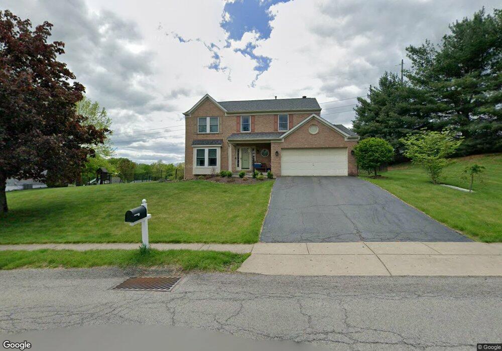
205 Pointe West Dr Mc Donald, PA 15057
Estimated Value: $423,000 - $494,000
4
Beds
3
Baths
2,010
Sq Ft
$228/Sq Ft
Est. Value
About This Home
This home is located at 205 Pointe West Dr, Mc Donald, PA 15057 and is currently estimated at $457,739, approximately $227 per square foot. 205 Pointe West Dr is a home located in Allegheny County with nearby schools including West Allegheny Senior High School.
Ownership History
Date
Name
Owned For
Owner Type
Purchase Details
Closed on
Feb 23, 2009
Sold by
Rosendale Russell K
Bought by
Dahmen Matthew A
Current Estimated Value
Home Financials for this Owner
Home Financials are based on the most recent Mortgage that was taken out on this home.
Original Mortgage
$240,463
Outstanding Balance
$152,651
Interest Rate
5.18%
Mortgage Type
FHA
Estimated Equity
$305,088
Purchase Details
Closed on
Dec 14, 2006
Sold by
Chapman Percy
Bought by
Rosendale Russell K
Home Financials for this Owner
Home Financials are based on the most recent Mortgage that was taken out on this home.
Original Mortgage
$166,000
Interest Rate
6.31%
Mortgage Type
New Conventional
Create a Home Valuation Report for This Property
The Home Valuation Report is an in-depth analysis detailing your home's value as well as a comparison with similar homes in the area
Home Values in the Area
Average Home Value in this Area
Purchase History
| Date | Buyer | Sale Price | Title Company |
|---|---|---|---|
| Dahmen Matthew A | $244,900 | -- | |
| Rosendale Russell K | $207,500 | -- |
Source: Public Records
Mortgage History
| Date | Status | Borrower | Loan Amount |
|---|---|---|---|
| Open | Dahmen Matthew A | $240,463 | |
| Previous Owner | Rosendale Russell K | $166,000 |
Source: Public Records
Tax History Compared to Growth
Tax History
| Year | Tax Paid | Tax Assessment Tax Assessment Total Assessment is a certain percentage of the fair market value that is determined by local assessors to be the total taxable value of land and additions on the property. | Land | Improvement |
|---|---|---|---|---|
| 2025 | $6,020 | $226,900 | $40,700 | $186,200 |
| 2024 | $6,020 | $226,900 | $40,700 | $186,200 |
| 2023 | $6,020 | $226,900 | $40,700 | $186,200 |
| 2022 | $6,020 | $226,900 | $40,700 | $186,200 |
| 2021 | $6,020 | $226,900 | $40,700 | $186,200 |
| 2020 | $6,020 | $226,900 | $40,700 | $186,200 |
| 2019 | $6,020 | $226,900 | $40,700 | $186,200 |
| 2018 | $1,073 | $226,900 | $40,700 | $186,200 |
| 2017 | $6,020 | $226,900 | $40,700 | $186,200 |
| 2016 | $1,073 | $226,900 | $40,700 | $186,200 |
| 2015 | $1,073 | $226,900 | $40,700 | $186,200 |
| 2014 | $6,020 | $226,900 | $40,700 | $186,200 |
Source: Public Records
Map
Nearby Homes
- 103 Hollyberry Cir
- 845 Wall St
- 319 Dupont Dr
- 100 Hill Place Dr
- 146 Mcvey St
- 1103 Hoffman Dr
- 809 Station St
- 1015 Granite Dr
- Lot 4 McVey Street Extension
- Lot 3 McVey Street Extension
- 7712 Noblestown Rd
- 0 McVey St Extension Unit 1692515
- Lot 3166 Robinson Run Rd
- 238 State St W
- 205 Spring St
- 403 Clinton Ave
- 101 Dempe St
- 4401 Battle Ridge Rd
- Carlisle Plan at Stonegate
- Tucson Plan at Stonegate
- 205 Pointe Dr W
- 203 Pointe West Dr
- 203 Pointe Dr W
- 207 Pointe West Dr
- 207 Pointe Dr W
- 206 Pointe West Dr
- 206 Pointe West Dr
- 204 Pointe West Dr
- 208 Pointe West Dr
- 208 Pointe Dr W
- 946 Fairfield Ln
- 201 Pointe West Dr
- 202 Pointe West Dr
- 104 Western Circle Dr
- 210 Pointe West Dr
- 943 Fairfield Ln
- 944 Fairfield Ln
- 1001 Fairfield Ln
- 200 Pointe West Dr
- 106 Western Circle Dr