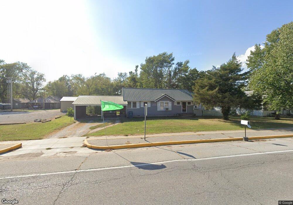
205 S Main St Quapaw, OK 74363
Estimated Value: $60,000 - $103,000
2
Beds
2
Baths
956
Sq Ft
$81/Sq Ft
Est. Value
About This Home
This home is located at 205 S Main St, Quapaw, OK 74363 and is currently estimated at $77,274, approximately $80 per square foot. 205 S Main St is a home located in Ottawa County with nearby schools including Quapaw Elementary School, Quapaw Middle School, and Quapaw High School.
Ownership History
Date
Name
Owned For
Owner Type
Purchase Details
Closed on
Oct 25, 2010
Sold by
Forrester Carolyn Mae
Bought by
Wall Dallas G and Wall Patsy P
Current Estimated Value
Home Financials for this Owner
Home Financials are based on the most recent Mortgage that was taken out on this home.
Original Mortgage
$26,012
Outstanding Balance
$17,258
Interest Rate
4.38%
Mortgage Type
Purchase Money Mortgage
Estimated Equity
$60,016
Purchase Details
Closed on
Aug 17, 2004
Bought by
Forrester Carolyn Mae
Purchase Details
Closed on
Dec 1, 2003
Bought by
Jackson Ruby Maxine
Purchase Details
Closed on
Mar 26, 2001
Bought by
Richardson Patricia
Create a Home Valuation Report for This Property
The Home Valuation Report is an in-depth analysis detailing your home's value as well as a comparison with similar homes in the area
Home Values in the Area
Average Home Value in this Area
Purchase History
| Date | Buyer | Sale Price | Title Company |
|---|---|---|---|
| Wall Dallas G | $22,500 | Photo Abstract Co | |
| Forrester Carolyn Mae | -- | -- | |
| Jackson Ruby Maxine | -- | -- | |
| Richardson Patricia | -- | -- |
Source: Public Records
Mortgage History
| Date | Status | Borrower | Loan Amount |
|---|---|---|---|
| Open | Wall Dallas G | $26,012 |
Source: Public Records
Tax History Compared to Growth
Tax History
| Year | Tax Paid | Tax Assessment Tax Assessment Total Assessment is a certain percentage of the fair market value that is determined by local assessors to be the total taxable value of land and additions on the property. | Land | Improvement |
|---|---|---|---|---|
| 2024 | $363 | $4,387 | $656 | $3,731 |
| 2023 | $363 | $4,178 | $656 | $3,522 |
| 2022 | $338 | $3,979 | $656 | $3,323 |
| 2021 | $269 | $3,790 | $656 | $3,134 |
| 2020 | $257 | $3,609 | $871 | $2,738 |
| 2019 | $244 | $3,437 | $852 | $2,585 |
| 2018 | $233 | $3,274 | $834 | $2,440 |
| 2017 | $222 | $3,118 | $817 | $2,301 |
| 2016 | $211 | $2,969 | $800 | $2,169 |
| 2015 | $176 | $2,575 | $243 | $2,332 |
| 2014 | $201 | $2,828 | $762 | $2,066 |
Source: Public Records
Map
Nearby Homes
- 11 Jackson St
- 3991 S 600 Rd
- 110 Stafford St
- 3880 S 590 Rd
- 5401 S 620 Rd
- 62751 E 69 Rd
- 0000 S 637 Rd
- 12001 SE Us-69 Hwy
- 12001 SE Hwy 69
- 3135 Shepard Ave
- 637 W 30th St
- 615 N Mickey Mantle Blvd
- 309 W 25th St
- 4461 S 650 Rd
- 401 N Elm St
- 1010 E 34th St
- 10301 S 600 Rd
- 3110 Gaineswood Ave
- 3330 Edgewood Ave
- 3050 Gaineswood Ave
- 203 S Main St
- 207 S Main St
- 201 S Main St
- 219 N Main St
- 204 Kentucky St
- 206 Kentucky St
- 208 Kentucky St
- 200 Kentucky St
- 210 Kentucky St
- 212 Kentucky St
- 214 Kentucky St
- 104 Kentucky St
- 220 N Main St
- 212 S Main St
- 207 Kentucky St
- 205 Kentucky St
- 209 Kentucky St
- 201 Virginia St
- 100 Kentucky St
- 215 Kentucky St