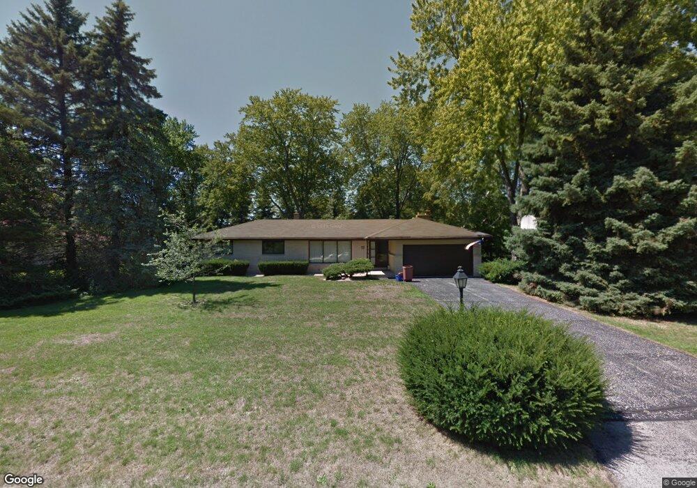
205 S Rolland Rd Brookfield, WI 53005
Estimated Value: $474,000 - $617,000
4
Beds
3
Baths
2,163
Sq Ft
$239/Sq Ft
Est. Value
About This Home
This home is located at 205 S Rolland Rd, Brookfield, WI 53005 and is currently estimated at $517,104, approximately $239 per square foot. 205 S Rolland Rd is a home located in Waukesha County with nearby schools including Swanson Elementary School, Wisconsin Hills Middle School, and Brookfield Central High School.
Ownership History
Date
Name
Owned For
Owner Type
Purchase Details
Closed on
Dec 29, 2022
Sold by
Petrey Laura E
Bought by
Petrey Adam Sl
Current Estimated Value
Purchase Details
Closed on
Mar 31, 2015
Sold by
Emaci Edward and Emaci Margarita
Bought by
Petrey Adam and Petrey Laura
Home Financials for this Owner
Home Financials are based on the most recent Mortgage that was taken out on this home.
Original Mortgage
$284,050
Interest Rate
3.73%
Mortgage Type
New Conventional
Purchase Details
Closed on
Jan 12, 2002
Sold by
Palmersheim Thomas E and Palmersheim Robert J
Bought by
Emaci Edward and Emaci Margarita
Home Financials for this Owner
Home Financials are based on the most recent Mortgage that was taken out on this home.
Original Mortgage
$174,320
Interest Rate
7.24%
Mortgage Type
Balloon
Create a Home Valuation Report for This Property
The Home Valuation Report is an in-depth analysis detailing your home's value as well as a comparison with similar homes in the area
Home Values in the Area
Average Home Value in this Area
Purchase History
| Date | Buyer | Sale Price | Title Company |
|---|---|---|---|
| Petrey Adam Sl | -- | None Listed On Document | |
| Petrey Adam | $299,000 | None Available | |
| Emaci Edward | $219,900 | -- |
Source: Public Records
Mortgage History
| Date | Status | Borrower | Loan Amount |
|---|---|---|---|
| Previous Owner | Petrey Adam | $284,050 | |
| Previous Owner | Emaci Edward | $174,320 |
Source: Public Records
Tax History
| Year | Tax Paid | Tax Assessment Tax Assessment Total Assessment is a certain percentage of the fair market value that is determined by local assessors to be the total taxable value of land and additions on the property. | Land | Improvement |
|---|---|---|---|---|
| 2024 | $4,836 | $408,600 | $125,000 | $283,600 |
| 2023 | $4,518 | $408,600 | $125,000 | $283,600 |
| 2022 | $4,871 | $323,700 | $110,000 | $213,700 |
| 2021 | $4,843 | $323,700 | $110,000 | $213,700 |
| 2020 | $5,066 | $323,700 | $110,000 | $213,700 |
| 2019 | $4,861 | $323,700 | $110,000 | $213,700 |
| 2018 | $4,286 | $278,700 | $110,000 | $168,700 |
| 2017 | $4,987 | $278,700 | $110,000 | $168,700 |
| 2016 | $4,360 | $278,700 | $110,000 | $168,700 |
| 2015 | $4,339 | $278,700 | $110,000 | $168,700 |
| 2014 | $4,485 | $268,700 | $110,000 | $158,700 |
| 2013 | $4,333 | $268,700 | $110,000 | $158,700 |
Source: Public Records
Map
Nearby Homes
- 885 Rocky Point Unit C
- 1170 Forest Ln
- 17685 Evergreen Ct
- 18575 Brookfield Lake Dr Unit 61
- 18275 Brookfield Lake Dr Unit 93
- 18535 Stonehedge Dr Unit A
- 18520 Emerald Cir Unit F
- 18710 Follett Dr Unit 502
- 18775 Brookfield Lake Dr Unit 8
- 18925 Eagle Dr Unit 101
- 18925 Eagle Dr Unit 102
- 18925 Eagle Dr Unit 202
- 18925 Eagle Dr Unit 201
- 16107 W Heritage Ln Unit 16107
- 15330 Huff Way
- 15270 Huff Way
- 15105 Froedtert Dr
- Lt0 W Greenfield Ave
- 1124 Pilgrim Pkwy
- 1150 Pilgrim Pkwy Unit 1150
- 175 S Rolland Rd
- 235 S Rolland Rd
- 210 Betty Ln
- 160 Betty Ln
- 230 Betty Ln
- 210 S Rolland Rd
- 180 S Rolland Rd
- 145 S Rolland Rd
- 265 S Rolland Rd
- 240 S Rolland Rd
- 150 S Rolland Rd
- 130 Betty Ln
- 17060 Deer Park Dr
- 215 Betty Ln
- 185 Joanne Dr
- 225 Joanne Dr
- 175 Betty Ln
- 16950 Deer Park Dr
- 17130 Deer Park Dr
- 17015 Golf Pkwy
Your Personal Tour Guide
Ask me questions while you tour the home.