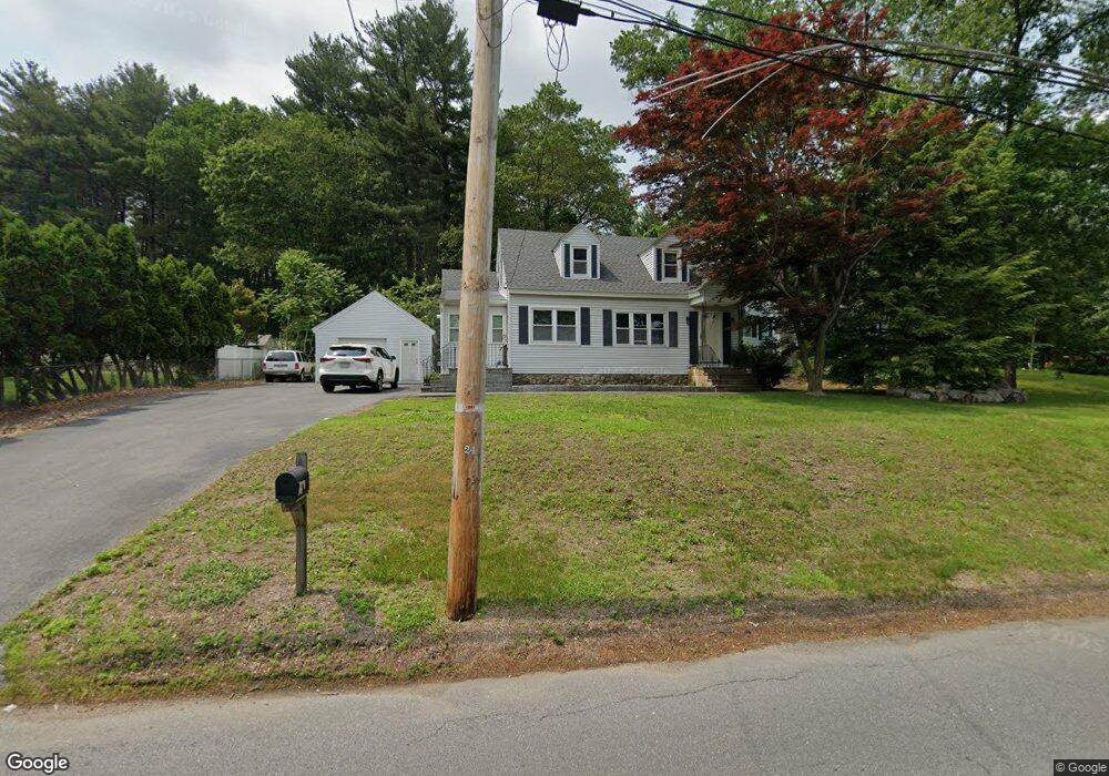
205 Varnum Rd Dracut, MA 01826
Estimated Value: $538,000 - $575,000
3
Beds
2
Baths
1,600
Sq Ft
$348/Sq Ft
Est. Value
About This Home
This home is located at 205 Varnum Rd, Dracut, MA 01826 and is currently estimated at $557,032, approximately $348 per square foot. 205 Varnum Rd is a home located in Middlesex County with nearby schools including Brookside Elementary School, Richardson Middle School, and Dracut Senior High School.
Ownership History
Date
Name
Owned For
Owner Type
Purchase Details
Closed on
Jan 19, 2018
Sold by
Mclaughlin James J and Mclaughlin Dyanne R
Bought by
Mclaughlin-Parent Dawna and Mclaughlin Brad
Current Estimated Value
Purchase Details
Closed on
Mar 30, 1973
Bought by
Mclaughlin James J and Mclaughlin Dyanne R
Create a Home Valuation Report for This Property
The Home Valuation Report is an in-depth analysis detailing your home's value as well as a comparison with similar homes in the area
Home Values in the Area
Average Home Value in this Area
Purchase History
| Date | Buyer | Sale Price | Title Company |
|---|---|---|---|
| Mclaughlin-Parent Dawna | -- | -- | |
| Mclaughlin James J | $20,000 | -- |
Source: Public Records
Mortgage History
| Date | Status | Borrower | Loan Amount |
|---|---|---|---|
| Previous Owner | Mclaughlin James J | $40,000 |
Source: Public Records
Tax History
| Year | Tax Paid | Tax Assessment Tax Assessment Total Assessment is a certain percentage of the fair market value that is determined by local assessors to be the total taxable value of land and additions on the property. | Land | Improvement |
|---|---|---|---|---|
| 2025 | $5,053 | $499,300 | $192,200 | $307,100 |
| 2024 | $4,843 | $463,400 | $183,000 | $280,400 |
| 2023 | $4,677 | $403,900 | $159,100 | $244,800 |
| 2022 | $4,567 | $371,600 | $144,600 | $227,000 |
| 2021 | $10,217 | $340,700 | $131,500 | $209,200 |
| 2020 | $4,438 | $332,400 | $127,700 | $204,700 |
| 2019 | $4,487 | $326,300 | $121,600 | $204,700 |
| 2018 | $4,082 | $288,700 | $121,600 | $167,100 |
| 2017 | $3,835 | $288,700 | $121,600 | $167,100 |
| 2016 | $3,714 | $250,300 | $116,900 | $133,400 |
| 2015 | $3,637 | $243,600 | $116,900 | $126,700 |
| 2014 | $3,452 | $238,200 | $116,900 | $121,300 |
Source: Public Records
Map
Nearby Homes
- 29 Mill St Unit B
- 17 Spare St
- 13 Dallas Dr Unit 305
- 13 Dallas Dr Unit 107
- 1905 Lakeview Ave
- 124 Tennis Plaza Rd Unit 40
- 53 Vinal St
- 94 Tennis Plaza Rd Unit 10
- 9 Arbor Dr
- 43 & 53 5th St
- 84 Tennis Plaza Rd Unit 1
- 74 Tennis Plaza Rd Unit 34
- 69 Springdale Ave
- 83 Turgeon Ave
- 179 Lakeview Ave
- 91 Frederick St Unit 77
- 154 New Boston Rd
- 42 Frederick St Unit 9
- 109 Navy Yard Rd
- 67 Glennon Ave
- 215 Varnum Rd
- 201 Varnum Rd
- 202 Varnum Rd
- 214 Varnum Rd
- 221 Varnum Rd
- 191 Varnum Rd
- 194 Varnum Rd
- 220 Varnum Rd
- 228 Varnum Rd
- 235 Varnum Rd
- 184 Varnum Rd
- 179 Varnum Rd
- 236 Varnum Rd
- 241 Varnum Rd
- 2189 Lakeview Ave
- 176 Varnum Rd
- 2205 Lakeview Ave
- 465 Nashua Rd Unit 6
- 465 Nashua Rd Unit 1
- 465 Nashua Rd Unit 7
Your Personal Tour Guide
Ask me questions while you tour the home.