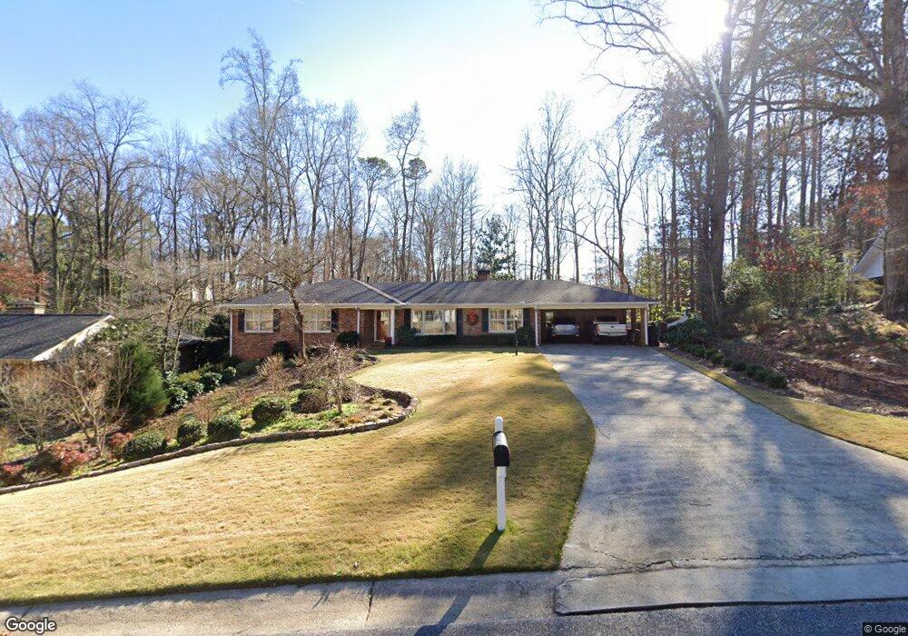
205 W Spalding Dr NE Atlanta, GA 30328
Estimated Value: $653,453 - $720,000
4
Beds
3
Baths
2,002
Sq Ft
$340/Sq Ft
Est. Value
About This Home
This home is located at 205 W Spalding Dr NE, Atlanta, GA 30328 and is currently estimated at $680,613, approximately $339 per square foot. 205 W Spalding Dr NE is a home located in Fulton County with nearby schools including Spalding Drive Elementary School, Sandy Springs Middle School, and North Springs High School.
Ownership History
Date
Name
Owned For
Owner Type
Purchase Details
Closed on
Apr 30, 2010
Sold by
Bonnano Eugenia T
Bought by
Robertson Roy R and Robertson Rebecca S
Current Estimated Value
Home Financials for this Owner
Home Financials are based on the most recent Mortgage that was taken out on this home.
Original Mortgage
$259,000
Interest Rate
4.77%
Mortgage Type
New Conventional
Purchase Details
Closed on
Jul 19, 2002
Sold by
Bonanno Nicholas S
Bought by
Bonanno Eugenia T
Create a Home Valuation Report for This Property
The Home Valuation Report is an in-depth analysis detailing your home's value as well as a comparison with similar homes in the area
Home Values in the Area
Average Home Value in this Area
Purchase History
| Date | Buyer | Sale Price | Title Company |
|---|---|---|---|
| Robertson Roy R | $329,000 | -- | |
| Bonanno Eugenia T | -- | -- |
Source: Public Records
Mortgage History
| Date | Status | Borrower | Loan Amount |
|---|---|---|---|
| Previous Owner | Robertson Roy R | $259,000 |
Source: Public Records
Tax History Compared to Growth
Tax History
| Year | Tax Paid | Tax Assessment Tax Assessment Total Assessment is a certain percentage of the fair market value that is determined by local assessors to be the total taxable value of land and additions on the property. | Land | Improvement |
|---|---|---|---|---|
| 2025 | $2,402 | $262,520 | $117,880 | $144,640 |
| 2023 | $5,869 | $207,920 | $62,280 | $145,640 |
| 2022 | $2,438 | $207,920 | $62,280 | $145,640 |
| 2021 | $2,410 | $215,040 | $80,760 | $134,280 |
| 2020 | $2,407 | $178,080 | $59,120 | $118,960 |
| 2019 | $2,362 | $174,920 | $58,080 | $116,840 |
| 2018 | $2,636 | $158,120 | $34,320 | $123,800 |
| 2017 | $3,632 | $136,920 | $25,000 | $111,920 |
| 2016 | $3,629 | $136,920 | $25,000 | $111,920 |
| 2015 | $3,636 | $136,920 | $25,000 | $111,920 |
| 2014 | $3,533 | $125,840 | $28,760 | $97,080 |
Source: Public Records
Map
Nearby Homes
- 229 Devonwood Dr
- 120 Seville Chase NW Unit 2
- 615 Mark Trail Ct NW
- 241 Hillswick Ct NE
- 6900 Roswell Rd Unit G1
- 6900 Roswell Rd Unit F6
- 6900 Roswell Rd Unit Q26
- 6900 Roswell Rd Unit F8
- 6900 Roswell Rd Unit 7N
- 6900 Roswell Rd Unit 10Q
- 6900 Roswell Rd Unit 5G
- 6900 Roswell Rd Unit G5
- 380 Thornwood Dr NE
- 7090 Stonington Dr NE
- 6980 Roswell Rd NE Unit A8
- 6980 Roswell Rd NE Unit M1
- 6980 Roswell Rd NE Unit 6
- 215 W Spalding Dr NE
- 195 W Spalding Dr NE
- W W Spalding Dr
- 204 Devonwood Dr NE
- 208 Devonwood Dr NE
- 200 Devonwood Dr NE
- 200 W Spalding Dr NE
- 190 Devonwood Dr NE
- 228 Devonwood Dr NE Unit 5
- 190 W Spalding Dr NE
- 216 Devonwood Dr NE
- 210 W Spalding Dr NE
- 235 W Spalding Dr NE
- 175 W Spalding Dr NE
- 234 Devonwood Dr NE
- 180 Devonwood Dr NE Unit 3
- 0 Devonwood Dr Unit 7283175
- 0 Devonwood Dr Unit 7160188
- 0 Devonwood Dr Unit 7113823