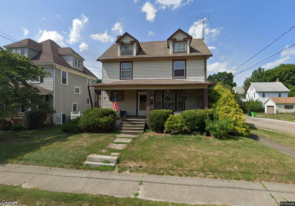
205 W Summit St Alliance, OH 44601
Estimated Value: $81,000 - $123,000
3
Beds
2
Baths
1,628
Sq Ft
$63/Sq Ft
Est. Value
About This Home
This home is located at 205 W Summit St, Alliance, OH 44601 and is currently estimated at $102,357, approximately $62 per square foot. 205 W Summit St is a home located in Stark County with nearby schools including Alliance Early Learning School, Alliance Intermediate School at Northside, and Alliance Middle School.
Ownership History
Date
Name
Owned For
Owner Type
Purchase Details
Closed on
Mar 27, 2011
Sold by
Johnson Mary Jane and Johnson Keith A
Bought by
Shank Stacey B and Shank Raymond
Current Estimated Value
Home Financials for this Owner
Home Financials are based on the most recent Mortgage that was taken out on this home.
Original Mortgage
$22,500
Interest Rate
4.99%
Mortgage Type
New Conventional
Create a Home Valuation Report for This Property
The Home Valuation Report is an in-depth analysis detailing your home's value as well as a comparison with similar homes in the area
Home Values in the Area
Average Home Value in this Area
Purchase History
| Date | Buyer | Sale Price | Title Company |
|---|---|---|---|
| Shank Stacey B | $25,000 | None Available |
Source: Public Records
Mortgage History
| Date | Status | Borrower | Loan Amount |
|---|---|---|---|
| Closed | Shank Stacey B | $22,500 |
Source: Public Records
Tax History Compared to Growth
Tax History
| Year | Tax Paid | Tax Assessment Tax Assessment Total Assessment is a certain percentage of the fair market value that is determined by local assessors to be the total taxable value of land and additions on the property. | Land | Improvement |
|---|---|---|---|---|
| 2025 | -- | $29,230 | $6,580 | $22,650 |
| 2024 | -- | $29,230 | $6,580 | $22,650 |
| 2023 | $843 | $20,970 | $6,130 | $14,840 |
| 2022 | $848 | $20,970 | $6,130 | $14,840 |
| 2021 | $849 | $20,970 | $6,130 | $14,840 |
| 2020 | $803 | $18,520 | $5,320 | $13,200 |
| 2019 | $792 | $18,520 | $5,320 | $13,200 |
| 2018 | $795 | $18,520 | $5,320 | $13,200 |
| 2017 | $689 | $15,790 | $4,310 | $11,480 |
| 2016 | $695 | $15,790 | $4,310 | $11,480 |
| 2015 | $701 | $15,790 | $4,310 | $11,480 |
| 2014 | $749 | $16,070 | $4,380 | $11,690 |
| 2013 | $374 | $16,070 | $4,380 | $11,690 |
Source: Public Records
Map
Nearby Homes
- 140 W Summit St
- 427 S Union Ave
- 807 S Union Ave
- 645 W Summit St
- 132 S Haines Ave
- 163 W Market St
- 725 W Summit St
- 345 W Market St
- 734 Parkway Blvd
- 329 1/2 W Main St
- 432 S Linden Ave
- 356 E Broadway St
- 896 Parkway Blvd
- 452 E Summit St
- 738 Kingsway St
- V/L S Fredeom Ave
- 361 E Main St
- 1005 S Freedom Ave
- 511 W Ely St
- 970 Kingsway St
- 211 W Summit St
- 151 W Summit St
- 221 W Summit St
- 649 Keplinger Ave
- 143 W Summit St
- 237 W Summit St
- 654 Keplinger Ave
- 643 Keplinger Ave
- 220 W Summit St
- 135 W Summit St
- 646 Keplinger Ave
- 222 W Summit St
- 247 W Summit St
- 650 S Haines Ave
- 638 Keplinger Ave
- 240 W Summit St
- 720 Keplinger Ave
- 640 S Haines Ave
- 123 W Summit St
- 251 W Summit St