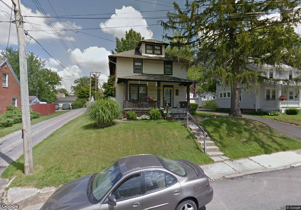
205 Westwood Ave Mansfield, OH 44906
Estimated Value: $112,000 - $127,885
3
Beds
2
Baths
1,200
Sq Ft
$100/Sq Ft
Est. Value
About This Home
This home is located at 205 Westwood Ave, Mansfield, OH 44906 and is currently estimated at $119,471, approximately $99 per square foot. 205 Westwood Ave is a home located in Richland County with nearby schools including Goal Digital Academy, Discovery School, and St. Peter's High School/Junior High.
Ownership History
Date
Name
Owned For
Owner Type
Purchase Details
Closed on
Jan 27, 2025
Sold by
Feeney Lori Sue
Bought by
Performance Foods Corp
Current Estimated Value
Purchase Details
Closed on
May 5, 2000
Sold by
Kline Thomas H
Bought by
Feeney Lori S
Home Financials for this Owner
Home Financials are based on the most recent Mortgage that was taken out on this home.
Original Mortgage
$37,800
Interest Rate
8.24%
Mortgage Type
New Conventional
Create a Home Valuation Report for This Property
The Home Valuation Report is an in-depth analysis detailing your home's value as well as a comparison with similar homes in the area
Home Values in the Area
Average Home Value in this Area
Purchase History
| Date | Buyer | Sale Price | Title Company |
|---|---|---|---|
| Performance Foods Corp | $115,000 | None Listed On Document | |
| Performance Foods Corp | $115,000 | None Listed On Document | |
| Feeney Lori S | $72,500 | -- |
Source: Public Records
Mortgage History
| Date | Status | Borrower | Loan Amount |
|---|---|---|---|
| Previous Owner | Feeney Lori S | $37,800 |
Source: Public Records
Tax History Compared to Growth
Tax History
| Year | Tax Paid | Tax Assessment Tax Assessment Total Assessment is a certain percentage of the fair market value that is determined by local assessors to be the total taxable value of land and additions on the property. | Land | Improvement |
|---|---|---|---|---|
| 2024 | $1,208 | $25,800 | $3,550 | $22,250 |
| 2023 | $1,208 | $25,800 | $3,550 | $22,250 |
| 2022 | $1,038 | $18,570 | $3,050 | $15,520 |
| 2021 | $1,045 | $18,570 | $3,050 | $15,520 |
| 2020 | $1,068 | $18,570 | $3,050 | $15,520 |
| 2019 | $1,184 | $18,570 | $3,050 | $15,520 |
| 2018 | $1,168 | $18,570 | $3,050 | $15,520 |
| 2017 | $1,136 | $18,570 | $3,050 | $15,520 |
| 2016 | $1,031 | $16,340 | $4,200 | $12,140 |
| 2015 | $985 | $16,340 | $4,200 | $12,140 |
| 2014 | $972 | $16,340 | $4,200 | $12,140 |
| 2012 | $370 | $16,340 | $4,420 | $11,920 |
Source: Public Records
Map
Nearby Homes
- 133 Stewart Ave S
- 679 Coleman Rd
- 126 Dawson Ave
- 118 Parkwood Blvd
- 78 Glenwood Blvd
- 71 Glenwood Blvd
- 88 Sherman Ave
- 616 Cline Ave
- 191 Fairlawn Ave
- 143 Fairlawn Ave
- 135 Fairlawn Ave
- 41 Parkwood Blvd
- 129 Fairlawn Ave
- 76 Bartley Ave
- 24 Stewart Ave S
- 21 Glenwood Blvd
- 538 Broadview Ave
- 212 Marlow Rd
- 114 Vennum Ave
- 118 Lind Ave
- 209 Westwood Ave
- 199 Westwood Ave
- 574 Highland Ave
- 215 Westwood Ave
- 568 Highland Ave
- 594 Highland Ave
- 206 Westwood Ave
- 200 Westwood Ave
- 566 Highland Ave
- 196 Westwood Ave
- 598 Highland Ave
- 191 Westwood Ave
- 198 Dawson Ave
- 189 Westwood Ave
- 192 Westwood Ave
- 562 Highland Ave
- 194 Dawson Ave
- 573 Highland Ave
- 604 Highland Ave
- 209 Bennett St