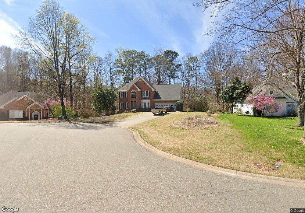
2050 Cedar Point Ln Cumming, GA 30041
Big Creek NeighborhoodEstimated Value: $555,000 - $650,000
4
Beds
3
Baths
2,517
Sq Ft
$237/Sq Ft
Est. Value
About This Home
This home is located at 2050 Cedar Point Ln, Cumming, GA 30041 and is currently estimated at $596,874, approximately $237 per square foot. 2050 Cedar Point Ln is a home located in Forsyth County with nearby schools including Daves Creek Elementary School, South Forsyth Middle School, and South Forsyth High School.
Ownership History
Date
Name
Owned For
Owner Type
Purchase Details
Closed on
May 28, 2010
Sold by
Kniple Joseph L and Kniple Sheri L
Bought by
Hutchinson James C and Hutchinson Pamela T
Current Estimated Value
Home Financials for this Owner
Home Financials are based on the most recent Mortgage that was taken out on this home.
Original Mortgage
$212,000
Outstanding Balance
$141,103
Interest Rate
4.83%
Mortgage Type
New Conventional
Estimated Equity
$455,771
Purchase Details
Closed on
Jul 14, 1998
Sold by
Clark Joel D and Clark Kelly S
Bought by
Kniple Joseph L and Kniple Sheri L
Home Financials for this Owner
Home Financials are based on the most recent Mortgage that was taken out on this home.
Original Mortgage
$171,000
Interest Rate
6.96%
Mortgage Type
New Conventional
Create a Home Valuation Report for This Property
The Home Valuation Report is an in-depth analysis detailing your home's value as well as a comparison with similar homes in the area
Home Values in the Area
Average Home Value in this Area
Purchase History
| Date | Buyer | Sale Price | Title Company |
|---|---|---|---|
| Hutchinson James C | $265,000 | -- | |
| Kniple Joseph L | $190,000 | -- |
Source: Public Records
Mortgage History
| Date | Status | Borrower | Loan Amount |
|---|---|---|---|
| Open | Hutchinson James C | $212,000 | |
| Previous Owner | Kniple Joseph L | $171,000 |
Source: Public Records
Tax History Compared to Growth
Tax History
| Year | Tax Paid | Tax Assessment Tax Assessment Total Assessment is a certain percentage of the fair market value that is determined by local assessors to be the total taxable value of land and additions on the property. | Land | Improvement |
|---|---|---|---|---|
| 2025 | $4,009 | $218,328 | $68,000 | $150,328 |
| 2024 | $4,009 | $200,368 | $60,000 | $140,368 |
| 2023 | $3,639 | $198,844 | $60,000 | $138,844 |
| 2022 | $3,789 | $130,084 | $32,000 | $98,084 |
| 2021 | $3,213 | $130,084 | $32,000 | $98,084 |
| 2020 | $3,125 | $125,828 | $32,000 | $93,828 |
| 2019 | $3,112 | $124,968 | $32,000 | $92,968 |
| 2018 | $3,146 | $125,832 | $24,000 | $101,832 |
| 2017 | $3,100 | $123,048 | $24,000 | $99,048 |
| 2016 | $3,057 | $121,048 | $22,000 | $99,048 |
| 2015 | $2,484 | $93,688 | $18,000 | $75,688 |
| 2014 | $2,222 | $87,232 | $0 | $0 |
Source: Public Records
Map
Nearby Homes
- 2040 Orr Rd
- 1330 Rogers Mill Ln
- 1120 Beech Ct
- 2420 Bronze Ct
- 2325 Melrose Trace
- 8930 Cobblestone Ln
- 2550 Wellsley Ln
- 8355 Ainsworth Dr
- 3711 Melody Mizer Ln
- 4965 Cheltenham Place
- 7047 Bennington Ln
- 1460 Badingham Dr
- 1255 Bookhout Dr
- 4865 Cheltenham Place
- 1065 Bookhout Dr
- 7030 Bennington Ln
- 3930 Medley Way
- 2071 Vicki Ln
- 3635 Crowchild Dr
- 2405 Bleckley Place
- 2040 Cedar Point Ln
- 2060 Cedar Point Ln
- 2030 Cedar Point Ln
- 2070 Cedar Point Ln
- 1910 Westwind Dr
- 2055 Cedar Point Ln
- 2020 Cedar Point Ln
- 1890 Westwind Dr
- 2090 Cedar Point Ln
- 2085 Cedar Point Ln
- 2096 Orr Rd
- 2110 Cedar Point Ln
- 2010 Cedar Point Ln
- 2070 Orr Rd
- 2005 Cedar Point Ln
- 2095 Cedar Point Ln
- 2035 Bethany Spring Trace
- 2045 Bethany Spring Trace
- 1870 Westwind Dr
- 1925 Bethany Spring Trace