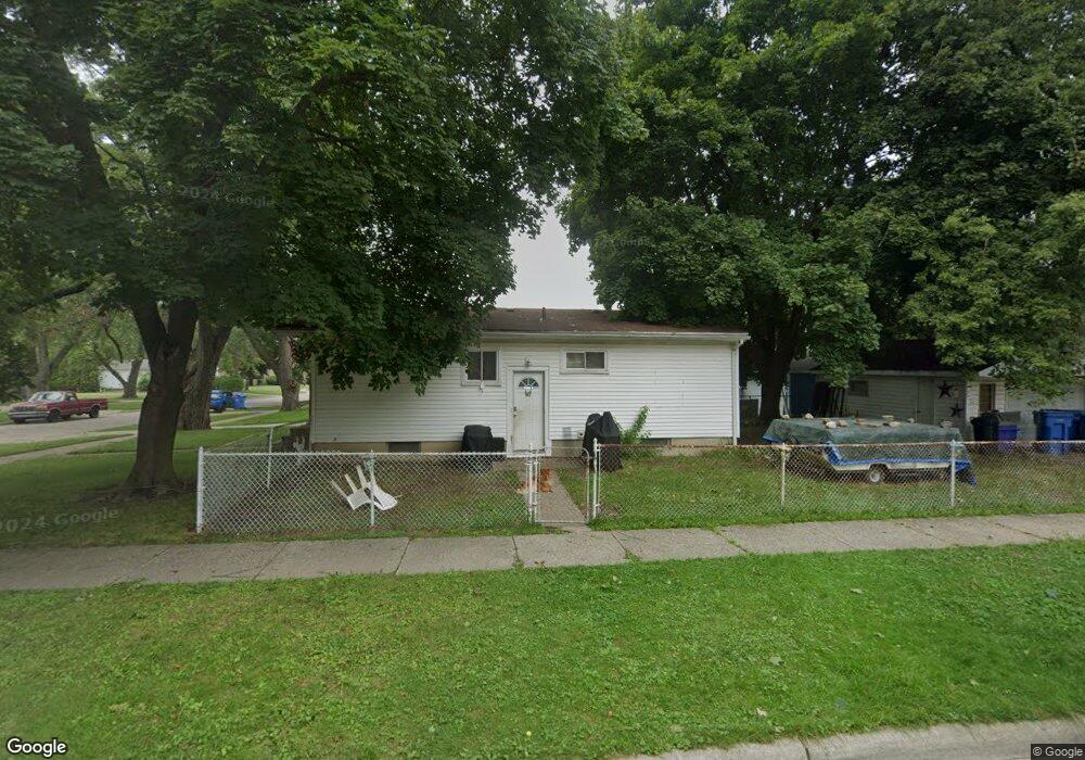
20502 Powers Ave Dearborn Heights, MI 48125
Estimated Value: $70,000 - $162,000
3
Beds
1
Bath
1,040
Sq Ft
$132/Sq Ft
Est. Value
About This Home
This home is located at 20502 Powers Ave, Dearborn Heights, MI 48125 and is currently estimated at $137,061, approximately $131 per square foot. 20502 Powers Ave is a home located in Wayne County with nearby schools including Polk Elementary School, Bedford School, and Pardee School.
Ownership History
Date
Name
Owned For
Owner Type
Purchase Details
Closed on
May 15, 2014
Sold by
Oxford Investments Llc
Bought by
Foreman Jeremy and Collins Kristal
Current Estimated Value
Home Financials for this Owner
Home Financials are based on the most recent Mortgage that was taken out on this home.
Original Mortgage
$58,000
Interest Rate
6.67%
Mortgage Type
Credit Line Revolving
Purchase Details
Closed on
Oct 27, 1995
Sold by
Murphy Michael J and Murphy Evelyn C
Bought by
Rice Jody M
Create a Home Valuation Report for This Property
The Home Valuation Report is an in-depth analysis detailing your home's value as well as a comparison with similar homes in the area
Home Values in the Area
Average Home Value in this Area
Purchase History
| Date | Buyer | Sale Price | Title Company |
|---|---|---|---|
| Foreman Jeremy | $69,000 | Reputation First Title | |
| Foreman Jeremy | $69,000 | Reputation First Title | |
| Oxford Investments Llc | -- | Reputation First Title | |
| Foreman Jeremy | -- | Reputation First Title Agenc | |
| Rice Jody M | $57,000 | First Michigan Title Agency |
Source: Public Records
Mortgage History
| Date | Status | Borrower | Loan Amount |
|---|---|---|---|
| Previous Owner | Foreman Jeremy | $58,000 |
Source: Public Records
Tax History
| Year | Tax Paid | Tax Assessment Tax Assessment Total Assessment is a certain percentage of the fair market value that is determined by local assessors to be the total taxable value of land and additions on the property. | Land | Improvement |
|---|---|---|---|---|
| 2025 | $1,333 | $75,500 | $0 | $0 |
| 2024 | $1,277 | $66,900 | $0 | $0 |
| 2023 | $1,207 | $58,700 | $0 | $0 |
| 2022 | $1,675 | $50,600 | $0 | $0 |
| 2021 | $3,409 | $43,800 | $0 | $0 |
| 2019 | $3,093 | $36,600 | $0 | $0 |
| 2018 | $2,027 | $31,500 | $0 | $0 |
| 2017 | $984 | $30,600 | $0 | $0 |
| 2016 | $1,549 | $29,900 | $0 | $0 |
| 2015 | $2,770 | $27,700 | $0 | $0 |
| 2013 | $2,760 | $28,700 | $0 | $0 |
| 2010 | -- | $37,900 | $0 | $0 |
Source: Public Records
Map
Nearby Homes
- 20602 Powers Ave
- 20616 Powers Ave
- 20313 Powers Ave
- 5607 Polk St
- 5621 Merrick St
- 4641 Weddell St
- 4833 Harding St
- 5652 Merrick St
- 4694 Ziegler St
- 4630 Pelham St
- 21006 Annapolis St
- 4913 Campbell St
- 4630 Gertrude St
- 4994 Campbell St
- 5873 Merrick St
- 4212 Huron St
- 4911 Detroit St
- 4993 Clippert St
- 5622 Campbell St
- 4205 Harding St
- 20516 Powers Ave
- 20524 Powers Ave Unit Bldg-Unit
- 20524 Powers Ave
- 4994 Huron St
- 20456 Powers Ave
- 20532 Powers Ave
- 20446 Powers Ave
- 20540 Powers Ave
- 4995 Huron St
- 20511 Powers Ave
- 20519 Powers Ave
- 4987 Huron St
- 20436 Powers Ave
- 4972 Huron St
- 4995 Hipp St
- 20527 Powers Ave
- 20455 Powers Ave
- 20550 Powers Ave Unit Bldg-Unit
- 20550 Powers Ave
- 4981 Huron St