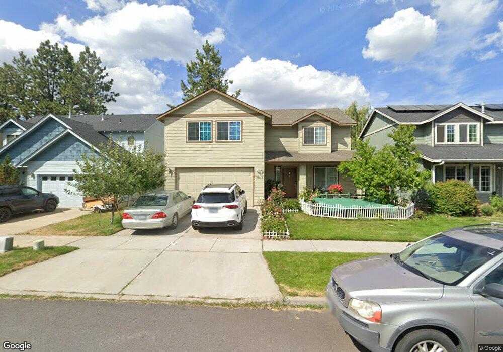
20512 Rolen Ave Bend, OR 97702
Old Farm District NeighborhoodEstimated Value: $543,000 - $646,000
4
Beds
3
Baths
1,952
Sq Ft
$306/Sq Ft
Est. Value
About This Home
This home is located at 20512 Rolen Ave, Bend, OR 97702 and is currently estimated at $598,264, approximately $306 per square foot. 20512 Rolen Ave is a home located in Deschutes County with nearby schools including Silver Rail Elementary School, High Desert Middle School, and Bend Senior High School.
Ownership History
Date
Name
Owned For
Owner Type
Purchase Details
Closed on
Jul 16, 2015
Sold by
Addington Renate E
Bought by
Vu Nghia C and Dang Thanh T
Current Estimated Value
Home Financials for this Owner
Home Financials are based on the most recent Mortgage that was taken out on this home.
Original Mortgage
$205,000
Outstanding Balance
$159,343
Interest Rate
3.85%
Mortgage Type
New Conventional
Estimated Equity
$438,921
Purchase Details
Closed on
Sep 14, 2004
Sold by
Somerset Development Llc
Bought by
Addington Delbert G and Addington Renate E
Create a Home Valuation Report for This Property
The Home Valuation Report is an in-depth analysis detailing your home's value as well as a comparison with similar homes in the area
Home Values in the Area
Average Home Value in this Area
Purchase History
| Date | Buyer | Sale Price | Title Company |
|---|---|---|---|
| Vu Nghia C | $265,000 | Western Title & Escrow | |
| Addington Delbert G | $199,900 | Amerititle |
Source: Public Records
Mortgage History
| Date | Status | Borrower | Loan Amount |
|---|---|---|---|
| Open | Vu Nghia C | $205,000 |
Source: Public Records
Tax History
| Year | Tax Paid | Tax Assessment Tax Assessment Total Assessment is a certain percentage of the fair market value that is determined by local assessors to be the total taxable value of land and additions on the property. | Land | Improvement |
|---|---|---|---|---|
| 2025 | $3,908 | $231,300 | -- | -- |
| 2024 | $3,760 | $224,570 | -- | -- |
| 2023 | $3,486 | $218,030 | $0 | $0 |
| 2022 | $3,252 | $205,520 | $0 | $0 |
| 2021 | $3,257 | $199,540 | $0 | $0 |
| 2020 | $3,090 | $199,540 | $0 | $0 |
| 2019 | $3,004 | $193,730 | $0 | $0 |
| 2018 | $2,919 | $188,090 | $0 | $0 |
| 2017 | $2,834 | $182,620 | $0 | $0 |
| 2016 | $2,702 | $177,310 | $0 | $0 |
| 2015 | $2,329 | $172,150 | $0 | $0 |
| 2014 | -- | $167,140 | $0 | $0 |
Source: Public Records
Map
Nearby Homes
- 61409 SE Daybreak Ct Unit Lot 2
- 61405 SE Daybreak Ct
- 61407 Kobe St
- 20560 Kira Dr Unit 371
- 61425 SE Daybreak Ct Unit Lot 6
- 61433 SE Daybreak Ct Unit Lot 8
- 20456 Brentwood Ave
- 61429 SE Daybreak Ct Unit Lot 7
- 20475 Del Coco Ct
- 61437 SE Daybreak Ct Unit Lot 9
- 61441 SE Daybreak Ct Unit Lot 10
- 20594 SE Slate Ave
- 20599 Kira Dr Unit 382
- 20600 Kira Dr Unit 362
- 20456 Del Coco Ct
- 20606 SE Slate Ave
- 20608 Rolen Ave
- 20609 SE Gemstone Ave Unit 131
- 20632 Kira Dr
- 20545 SE Evian Ave
- 20508 SE Rolen
- 20516 Rolen Ave
- 20508 Rolen Ave
- 20504 SE Rolen
- 20504 Rolen Ave
- 20520 Rolen Ave
- 20524 Rolen Ave
- 20524 SE Rolen
- 20500 Rolen Ave
- 20525 Barrows Ct
- 61430 Brosterhous Rd
- 61450 Brosterhous Rd
- 20528 Rolen Ave
- 20528 SE Rolen
- 20523 Rolen Ave
- 20529 Barrows Ct
- 20527 Rolen Ave
- 20532 Rolen Ave
- 20532 SE Rolen
- 61456 Brosterhous Rd
Your Personal Tour Guide
Ask me questions while you tour the home.