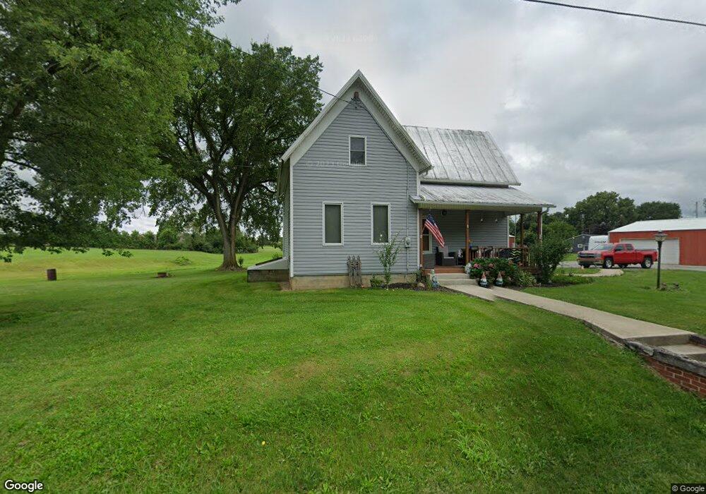
20523 State Route 47 Raymond, OH 43067
Estimated Value: $232,597 - $286,000
4
Beds
1
Bath
1,368
Sq Ft
$188/Sq Ft
Est. Value
About This Home
This home is located at 20523 State Route 47, Raymond, OH 43067 and is currently estimated at $256,649, approximately $187 per square foot. 20523 State Route 47 is a home located in Union County with nearby schools including North Union Elementary School, North Union Middle School, and North Union High School.
Ownership History
Date
Name
Owned For
Owner Type
Purchase Details
Closed on
Nov 8, 2022
Sold by
Mccomas Tony L and Mccomas Valerie K
Bought by
Myers Jason W and Myers Jenna N
Current Estimated Value
Purchase Details
Closed on
May 11, 1994
Bought by
Mccomas Tony L
Create a Home Valuation Report for This Property
The Home Valuation Report is an in-depth analysis detailing your home's value as well as a comparison with similar homes in the area
Home Values in the Area
Average Home Value in this Area
Purchase History
| Date | Buyer | Sale Price | Title Company |
|---|---|---|---|
| Myers Jason W | -- | -- | |
| Mccomas Tony L | -- | -- | |
| Mccomas Tony L | $54,500 | -- |
Source: Public Records
Tax History Compared to Growth
Tax History
| Year | Tax Paid | Tax Assessment Tax Assessment Total Assessment is a certain percentage of the fair market value that is determined by local assessors to be the total taxable value of land and additions on the property. | Land | Improvement |
|---|---|---|---|---|
| 2024 | $2,369 | $54,600 | $13,530 | $41,070 |
| 2023 | $2,369 | $54,600 | $13,530 | $41,070 |
| 2022 | $2,546 | $60,540 | $19,470 | $41,070 |
| 2021 | $2,032 | $44,380 | $14,980 | $29,400 |
| 2020 | $1,894 | $44,380 | $14,980 | $29,400 |
| 2019 | $1,906 | $44,380 | $14,980 | $29,400 |
| 2018 | $1,402 | $32,100 | $12,660 | $19,440 |
| 2017 | $1,393 | $32,100 | $12,660 | $19,440 |
| 2016 | $1,410 | $32,100 | $12,660 | $19,440 |
| 2015 | $1,125 | $24,590 | $12,660 | $11,930 |
| 2014 | $1,081 | $24,590 | $12,660 | $11,930 |
| 2013 | $1,099 | $24,590 | $12,660 | $11,930 |
Source: Public Records
Map
Nearby Homes
- 28370 State Route 739
- 21800 State Route 47
- 25875 Ohio 31
- 19250 Powder Lick Rd
- 30650 State Route 739
- 18055 Miller Rd
- 31434 State Route 31
- 31535 State Route 31
- 25400 Storms Rd
- 0 Ohio 31
- 23863 Drake Skidmore Rd
- 23750 Drake-Skidmore Rd
- 32220 State Route 31
- 0 Powder Lick Rd Unit 1016484
- 25883 Lunda Rd
- 184 E Mann St
- 21630 Main St
- 605 W Center St
- 23156 State Route 739
- 27900 Zook Rd
- 28350 State Route 739
- 28246 State Route 739
- 28299 State Route 739
- 28289 State Route 739
- 28249 Ohio 739
- 20421 State Route 47
- 28269 State Route 739
- 28353 State Route 739
- 28384 Ohio 739
- 20623 Ohio 47
- 20623 State Route 47
- 20421 Ohio 47
- 28375 State Route 739
- 20632 State Route 47
- 20642 State Route 47
- 28395 State Route 739
- 20655 State Route 47
- 20665 State Route 47
- 20385 State Route 47