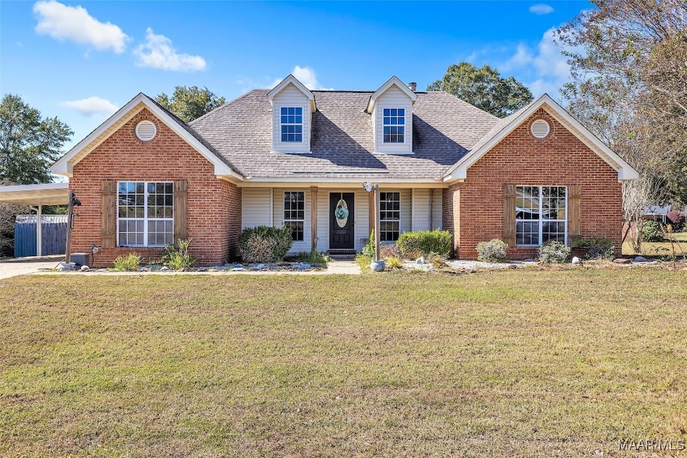
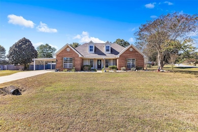
2053 Cedar Ridge Loop Prattville, AL 36067
Estimated payment $1,531/month
Highlights
- Mature Trees
- Deck
- Attic
- Pine Level Elementary School Rated 9+
- Wood Flooring
- 1 Fireplace
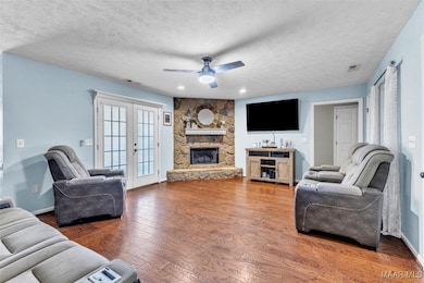
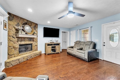
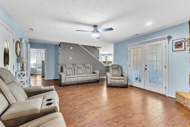
About This Home
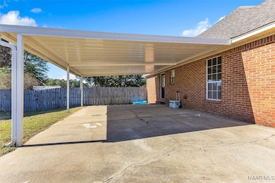
Don’t miss this one! It has a spacious bonus room upstairs that’s perfect for a playroom, home office, or guest space! This charming 3 bedroom, 2 bath Prattville home welcomes you with a beautiful living room featuring a stone wood-burning fireplace. The kitchen has plenty of cabinet space, a breakfast bar, and a comfortable flow into the dining area. The primary suite offers a full bath and walk-in closet. Enjoy mornings or evenings on the covered back deck overlooking the large yard, complete with a storage shed and carport. Sitting on a corner lot and full of character, this home feels warm, inviting, and ready for its next chapter! Call for a showing today!
Home Details
Home Type
- Single Family
Est. Annual Taxes
- $629
Year Built
- Built in 2003
Lot Details
- 0.4 Acre Lot
- Lot Dimensions are 100x300
- Corner Lot
- Mature Trees
Home Design
- Brick Exterior Construction
- Slab Foundation
Interior Spaces
- 1,998 Sq Ft Home
- 1.5-Story Property
- Tray Ceiling
- High Ceiling
- 1 Fireplace
- Double Pane Windows
- Tinted Windows
- Blinds
- Solar Screens
- Storage
- Washer and Dryer Hookup
- Attic
Kitchen
- Breakfast Bar
- Electric Oven
- Electric Cooktop
- Microwave
- Dishwasher
Flooring
- Wood
- Tile
Bedrooms and Bathrooms
- 3 Bedrooms
- Walk-In Closet
- 2 Full Bathrooms
Parking
- 2 Attached Carport Spaces
- Driveway
Outdoor Features
- Deck
- Covered Patio or Porch
- Outdoor Storage
Schools
- Pine Level Elementary School
- Marbury Middle School
- Marbury High School
Utilities
- Central Heating and Cooling System
- Electric Water Heater
Additional Features
- Energy-Efficient Windows
- Outside City Limits
Community Details
- No Home Owners Association
- Aspen Ridge Subdivision
Listing and Financial Details
- Assessor Parcel Number 10-03-05-0-000-013-059-0
Map
Home Values in the Area
Average Home Value in this Area
Tax History
| Year | Tax Paid | Tax Assessment Tax Assessment Total Assessment is a certain percentage of the fair market value that is determined by local assessors to be the total taxable value of land and additions on the property. | Land | Improvement |
|---|---|---|---|---|
| 2025 | $666 | $26,200 | $0 | $0 |
| 2024 | $629 | $24,800 | $0 | $0 |
| 2023 | $588 | $23,300 | $0 | $0 |
| 2022 | $489 | $19,620 | $0 | $0 |
| 2021 | $451 | $18,240 | $0 | $0 |
| 2020 | $423 | $17,200 | $0 | $0 |
| 2019 | $413 | $16,820 | $0 | $0 |
| 2018 | $416 | $16,940 | $0 | $0 |
| 2017 | $380 | $15,580 | $0 | $0 |
| 2015 | $370 | $0 | $0 | $0 |
| 2014 | $356 | $14,700 | $3,000 | $11,700 |
| 2013 | -- | $15,240 | $3,000 | $12,240 |
Property History
| Date | Event | Price | List to Sale | Price per Sq Ft |
|---|---|---|---|---|
| 10/28/2025 10/28/25 | For Sale | $280,000 | -- | $140 / Sq Ft |
Purchase History
| Date | Type | Sale Price | Title Company |
|---|---|---|---|
| Warranty Deed | $207,000 | None Listed On Document | |
| Warranty Deed | $207,000 | None Listed On Document | |
| Interfamily Deed Transfer | $159,000 | -- | |
| Deed | $127,900 | -- | |
| Deed | $15,500 | -- |
Mortgage History
| Date | Status | Loan Amount | Loan Type |
|---|---|---|---|
| Open | $203,250 | New Conventional | |
| Closed | $203,250 | New Conventional | |
| Previous Owner | $164,247 | Purchase Money Mortgage |
Source: Montgomery Area Association of REALTORS®
MLS Number: 581219
APN: 10-03-05-0-000-013-059-0
Disclaimer: Certain information contained herein is derived from information provided by parties other than Homes.com. All information provided is deemed reliable, but is not guaranteed to be accurate and should be independently verified.
![]() Information is deemed reliable, but not guaranteed. Listing Information Copyright 2025 Multiple Listing Service, Inc. of Montgomery Area Association of REALTORS® Inc. The information being provided is for consumers' personal, non-commercial use and will not be used for any purpose other than to identify prospective properties consumers may be interested in purchasing. The data relating to real estate for sale on this web site comes in part from the IDX Program of the Multiple Listing Service, Inc. of Montgomery Area Association of REALTORS® Inc. Real estate listings held by brokerage firms other than Ten-X are governed by MLS Rules and Regulations and detailed information about them includes the name of the listing companies.
Information is deemed reliable, but not guaranteed. Listing Information Copyright 2025 Multiple Listing Service, Inc. of Montgomery Area Association of REALTORS® Inc. The information being provided is for consumers' personal, non-commercial use and will not be used for any purpose other than to identify prospective properties consumers may be interested in purchasing. The data relating to real estate for sale on this web site comes in part from the IDX Program of the Multiple Listing Service, Inc. of Montgomery Area Association of REALTORS® Inc. Real estate listings held by brokerage firms other than Ten-X are governed by MLS Rules and Regulations and detailed information about them includes the name of the listing companies.
- 1920 Cedar Ridge Loop
- 13 Commercial Pkwy
- 11 Commercial Pkwy
- 10 Commercial Pkwy
- 6 Commercial Pkwy
- 4 Commercial Pkwy
- 8 Commercial Pkwy
- 7 Commercial Pkwy
- 2 Commercial Pkwy
- 12 Commercial Pkwy
- 5 Commercial Pkwy
- 15 Commercial Pkwy
- 3 Commercial Pkwy
- 14 Commercial Pkwy
- 2115 Waterstone Dr
- 321 County Road 82
- County Road 14
- 1212 Kenner Creek Cir
- 2929 White Cloud Ln
- 2002 Landcaster Ct
- 611 River Birch Dr
- 1626 Pine Lake Dr
- 1632 Pine Lake Dr
- 1892 Landing Place
- 107 Fox Run Dr
- 2153 County Road 57
- 211 Dawsons Mill Way
- 2039 Dawsons Mill Ln
- 107 Dawson's Mill Dr
- 107 Dawson's Ml Dr
- 1174 Old Prattville Rd
- 178 Gardenia Ct
- 553 Mt Airy Dr
- 745 Park Ln
- 463 Durden Rd Unit B
- 445 Deatsville Hwy
- 352 Millridge Dr
- 1310 Fairview Ave
- 102 White Oak Dr
- 386 Thornfield Dr
