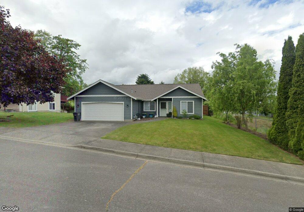
2054 Kiwi Dr Ferndale, WA 98248
Estimated Value: $561,471 - $647,000
3
Beds
2
Baths
1,590
Sq Ft
$376/Sq Ft
Est. Value
About This Home
This home is located at 2054 Kiwi Dr, Ferndale, WA 98248 and is currently estimated at $598,118, approximately $376 per square foot. 2054 Kiwi Dr is a home located in Whatcom County with nearby schools including Skyline Elementary School, Vista Middle School, and Ferndale High School.
Ownership History
Date
Name
Owned For
Owner Type
Purchase Details
Closed on
Sep 27, 2001
Sold by
Citicapital Relocation Inc
Bought by
Lang Chris and Lang Debbie
Current Estimated Value
Home Financials for this Owner
Home Financials are based on the most recent Mortgage that was taken out on this home.
Original Mortgage
$161,058
Outstanding Balance
$63,136
Interest Rate
6.91%
Mortgage Type
VA
Estimated Equity
$534,982
Purchase Details
Closed on
Oct 6, 1999
Sold by
Knutson Greg and Knutson Kristi
Bought by
Ferrandino Thomas M and Ferrandino Linda S
Home Financials for this Owner
Home Financials are based on the most recent Mortgage that was taken out on this home.
Original Mortgage
$134,900
Interest Rate
7.76%
Create a Home Valuation Report for This Property
The Home Valuation Report is an in-depth analysis detailing your home's value as well as a comparison with similar homes in the area
Home Values in the Area
Average Home Value in this Area
Purchase History
| Date | Buyer | Sale Price | Title Company |
|---|---|---|---|
| Lang Chris | $157,900 | Chicago Title Insurance | |
| Citicapital Relocation Inc | -- | Chicago Title Insurance | |
| Ferrandino Thomas M | $142,000 | Chicago Title Insurance |
Source: Public Records
Mortgage History
| Date | Status | Borrower | Loan Amount |
|---|---|---|---|
| Open | Lang Chris | $161,058 | |
| Previous Owner | Ferrandino Thomas M | $134,900 |
Source: Public Records
Tax History Compared to Growth
Tax History
| Year | Tax Paid | Tax Assessment Tax Assessment Total Assessment is a certain percentage of the fair market value that is determined by local assessors to be the total taxable value of land and additions on the property. | Land | Improvement |
|---|---|---|---|---|
| 2024 | $3,691 | $535,452 | $224,070 | $311,382 |
| 2023 | $3,691 | $530,406 | $231,000 | $299,406 |
| 2022 | $3,121 | $421,893 | $140,445 | $281,448 |
| 2021 | $3,144 | $348,671 | $116,070 | $232,601 |
| 2020 | $3,044 | $322,852 | $107,475 | $215,377 |
| 2019 | $2,341 | $281,195 | $93,608 | $187,587 |
| 2018 | $2,731 | $257,088 | $85,583 | $171,505 |
| 2017 | $2,441 | $225,298 | $75,000 | $150,298 |
| 2016 | $2,291 | $217,872 | $71,656 | $146,216 |
| 2015 | $2,296 | $205,062 | $67,841 | $137,221 |
| 2014 | -- | $200,833 | $66,300 | $134,533 |
| 2013 | -- | $198,069 | $65,000 | $133,069 |
Source: Public Records
Map
Nearby Homes
- 6157 Unrein Dr
- 2141 Jason Ct
- 77 xx Portal Way
- 6214 Malloy Ave
- 5865 Anderson Ave
- 5861 Malloy Ave
- 5879 Anderson Ave
- 5873 Anderson Ave
- 6216 Fernridge Ct
- 6218 N Beulah Ave
- 5863 Cedar St
- 6225 N Beulah Ave
- 2058 Andre Ct
- 5829 Vista Dr
- 1817 Eastgate Loop
- 2136 Hawthorne St
- 2144 Riverstone Loop
- 1825 Eastgate Loop
- 5910 Artist Dr
- 2091 Calico Loop