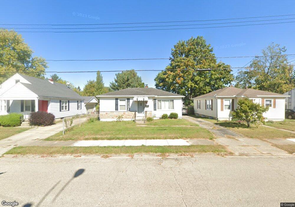
2054 Rutland Ave Springfield, OH 45505
Estimated Value: $107,000 - $123,000
About This Home
This home is located at 2054 Rutland Ave, Springfield, OH 45505 and is currently estimated at $118,183, approximately $128 per square foot. 2054 Rutland Ave is a home located in Clark County with nearby schools including Kenwood Elementary School, Hayward Middle School, and Springfield High School.
Ownership History
We collect this data history from publicly available records. To have your information removed, we recommend requesting removal directly through your county’s website.
Purchase Details
Home Financials for this Owner
Home Financials are based on the most recent Mortgage that was taken out on this home.Purchase Details
Home Financials for this Owner
Home Financials are based on the most recent Mortgage that was taken out on this home.Purchase Details
Home Financials for this Owner
Home Financials are based on the most recent Mortgage that was taken out on this home.Home Values in the Area
Average Home Value in this Area
Purchase History
We collect this data history from publicly available records. To have your information removed, we recommend requesting removal directly through your county’s website.
| Date | Buyer | Sale Price | Title Company |
|---|---|---|---|
| $52,000 | Ohio Real Estate Title | ||
| $73,000 | -- | ||
| $55,000 | -- |
Mortgage History
We collect this data history from publicly available records. To have your information removed, we recommend requesting removal directly through your county’s website.
| Date | Status | Borrower | Loan Amount |
|---|---|---|---|
| Open | $51,592 | ||
| Previous Owner | $72,427 | ||
| Previous Owner | $54,959 |
Tax History
We collect this data history from publicly available records. To have your information removed, we recommend requesting removal directly through your county’s website.
| Year | Tax Paid | Tax Assessment Tax Assessment Total Assessment is a certain percentage of the fair market value that is determined by local assessors to be the total taxable value of land and additions on the property. | Land | Improvement |
|---|---|---|---|---|
| 2025 | $1,240 | $29,240 | $4,000 | $25,240 |
| 2024 | $1,208 | $25,060 | $4,000 | $21,060 |
| 2023 | $1,208 | $25,060 | $4,000 | $21,060 |
| 2022 | $1,237 | $25,060 | $4,000 | $21,060 |
| 2021 | $977 | $18,260 | $2,860 | $15,400 |
| 2020 | $979 | $18,260 | $2,860 | $15,400 |
| 2019 | $981 | $18,260 | $2,860 | $15,400 |
| 2018 | $1,039 | $18,580 | $4,760 | $13,820 |
| 2017 | $1,039 | $18,582 | $4,760 | $13,822 |
| 2016 | $1,040 | $18,582 | $4,760 | $13,822 |
| 2015 | $1,060 | $18,582 | $4,760 | $13,822 |
| 2014 | $1,056 | $18,582 | $4,760 | $13,822 |
| 2013 | $1,044 | $18,582 | $4,760 | $13,822 |
Map
- 1907 Maryland Ave
- 1705 Rutland Ave
- 1652 Kenton St
- 1562 Rutland Ave
- 1625 E Pleasant St
- 1835 S Sweetbriar Ln
- 2217 S Hadley Rd
- 662 Reading Dr
- 1740 Victory Dr
- 621 S Douglas Ave
- 2214 Wrenwood Rd
- 1924 Victory Dr
- 643 Feese Place
- 729 Burt St
- 2201 Gerald Dr
- 1920 S Burnett Rd
- 2726 Morton Dr
- 910 Pine St
- 374 Raffensperger Ave
- 306 S Clairmont Ave
- 2068 Rutland Ave
- 2044 Rutland Ave
- 2080 Rutland Ave
- 2040 Rutland Ave
- 1317 Skyline Ln
- 1315 Skyline Ln
- 2104 Rutland Ave
- 2014 Rutland Ave
- 1314 Skyline Ln
- 2101 Rutland Ave
- 1309 Skyline Ln
- 2012 Rutland Ave
- 2112 Rutland Ave
- 2103 Rutland Ave
- 1310 Skyline Ln
- 2029 Rutland Ave
- 1307 Skyline Ln
- 2105 Rutland Ave
- 2010 Rutland Ave
- 2118 Rutland Ave
Ask me questions while you tour the home.