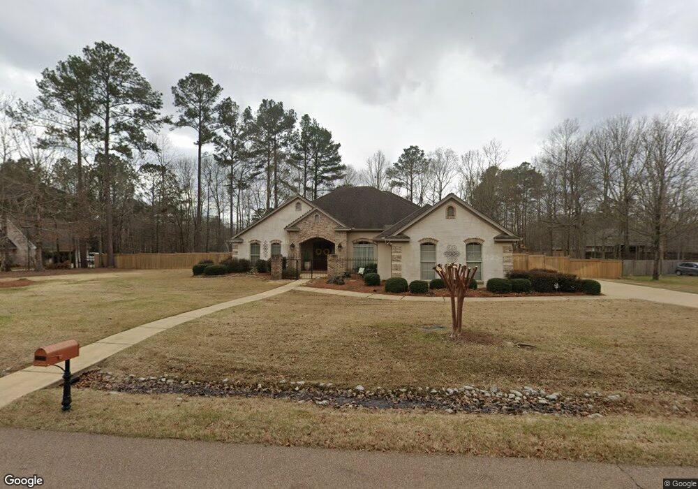
2056 Centre Pointe Dr Brandon, MS 39042
Estimated Value: $465,440 - $566,000
4
Beds
4
Baths
3,255
Sq Ft
$157/Sq Ft
Est. Value
About This Home
This home is located at 2056 Centre Pointe Dr, Brandon, MS 39042 and is currently estimated at $511,360, approximately $157 per square foot. 2056 Centre Pointe Dr is a home located in Rankin County with nearby schools including Rouse Elementary School, Brandon Elementary School, and Stonebridge Elementary School.
Ownership History
Date
Name
Owned For
Owner Type
Purchase Details
Closed on
Jun 21, 2010
Bought by
Rein John R and Rein Elizabeth Y
Current Estimated Value
Purchase Details
Closed on
Jul 13, 2007
Sold by
Hardin Ronnie A and Hardin Judy F
Bought by
White Chad Elbert and White Denise A
Home Financials for this Owner
Home Financials are based on the most recent Mortgage that was taken out on this home.
Original Mortgage
$292,000
Interest Rate
6.71%
Create a Home Valuation Report for This Property
The Home Valuation Report is an in-depth analysis detailing your home's value as well as a comparison with similar homes in the area
Home Values in the Area
Average Home Value in this Area
Purchase History
| Date | Buyer | Sale Price | Title Company |
|---|---|---|---|
| Rein John R | -- | -- | |
| White Chad Elbert | -- | -- |
Source: Public Records
Mortgage History
| Date | Status | Borrower | Loan Amount |
|---|---|---|---|
| Previous Owner | White Chad Elbert | $292,000 | |
| Previous Owner | White Chad Elbert | $73,304 |
Source: Public Records
Tax History
| Year | Tax Paid | Tax Assessment Tax Assessment Total Assessment is a certain percentage of the fair market value that is determined by local assessors to be the total taxable value of land and additions on the property. | Land | Improvement |
|---|---|---|---|---|
| 2025 | $4,411 | $35,596 | $0 | $0 |
| 2024 | $4,346 | $35,596 | $0 | $0 |
| 2023 | $3,157 | $35,693 | $0 | $0 |
| 2022 | $3,121 | $35,693 | $0 | $0 |
| 2021 | $3,121 | $35,693 | $0 | $0 |
| 2020 | $3,637 | $35,693 | $0 | $0 |
| 2019 | $3,188 | $31,689 | $0 | $0 |
| 2018 | $3,813 | $31,689 | $0 | $0 |
| 2017 | $3,813 | $31,689 | $0 | $0 |
| 2016 | $3,487 | $31,349 | $0 | $0 |
| 2015 | $3,487 | $31,349 | $0 | $0 |
| 2014 | -- | $33,741 | $0 | $0 |
| 2013 | -- | $29,387 | $0 | $0 |
Source: Public Records
Map
Nearby Homes
- 1222 Centre Ct
- 1002 Eastview Cove
- 1104 Pointe Cove
- 1106 Pointe Cove
- 305 Remington Dr
- 105 Easthaven Dr
- 103 Pimlico Dr
- 0 0 Grants Ferry Pkwy
- 0 Trickhambridge Rd
- 148 W Legacy Dr
- 109 W Legacy Dr
- 104 City Limits Rd
- 100 City Limits Rd
- 110 Trickhambridge Rd
- 0 Grants Ferry Pkwy Unit 4140325
- 329 Cornerstone Crossing
- 320 Cornerstone Crossing
- 319 Cornerstone Crossing
- 324 Cornerstone Crossing
- 330 Cornerstone Crossing
- 2046 Centre Pointe Dr
- 2066 Centre Pointe Dr
- 2055 Centre Pointe Dr
- 2065 Centre Pointe Dr
- 1220 Centre Ct
- 2036 Centre Pointe Dr
- 1224 Centre Ct
- 2045 Centre Pointe Dr
- 2076 Centre Pointe Dr
- 1218 Centre Ct
- 2075 Centre Pointe Dr
- 1070 Centre Pointe Dr
- 1004 Eastview Cove
- 2035 Centre Pointe Dr
- 1008 Eastview Cove
- 1010 Eastview Cove
- 1206 Centre Ct
- 1204 Centre Ct
- 1208 Centre Ct
- 1012 Eastview Cove
Your Personal Tour Guide
Ask me questions while you tour the home.