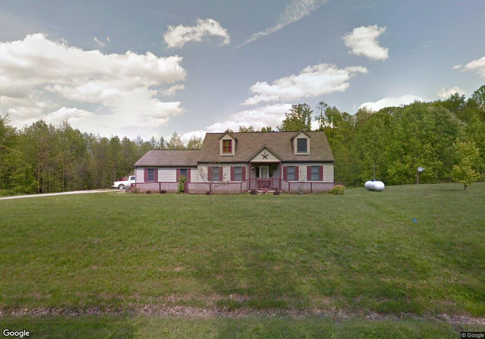
2056 Melon Hill Rd NE New Lexington, OH 43764
Estimated Value: $268,000 - $415,000
3
Beds
3
Baths
1,664
Sq Ft
$213/Sq Ft
Est. Value
About This Home
This home is located at 2056 Melon Hill Rd NE, New Lexington, OH 43764 and is currently estimated at $354,907, approximately $213 per square foot. 2056 Melon Hill Rd NE is a home with nearby schools including New Lexington Elementary School, Junction City Elementary School, and New Lexington Middle School.
Ownership History
Date
Name
Owned For
Owner Type
Purchase Details
Closed on
Jan 24, 2025
Sold by
Kitchen Waunita R and Ward Wayne C
Bought by
Ward Wayne C and Ward Loretta L
Current Estimated Value
Create a Home Valuation Report for This Property
The Home Valuation Report is an in-depth analysis detailing your home's value as well as a comparison with similar homes in the area
Home Values in the Area
Average Home Value in this Area
Purchase History
| Date | Buyer | Sale Price | Title Company |
|---|---|---|---|
| Ward Wayne C | -- | None Listed On Document |
Source: Public Records
Mortgage History
| Date | Status | Borrower | Loan Amount |
|---|---|---|---|
| Previous Owner | Ward Wayne C | $206,000 | |
| Previous Owner | Ward Wayne C | $41,000 | |
| Previous Owner | Ward Wayne C | $164,000 | |
| Previous Owner | Ward Wayne W | $180,000 |
Source: Public Records
Tax History Compared to Growth
Tax History
| Year | Tax Paid | Tax Assessment Tax Assessment Total Assessment is a certain percentage of the fair market value that is determined by local assessors to be the total taxable value of land and additions on the property. | Land | Improvement |
|---|---|---|---|---|
| 2024 | $3,250 | $90,090 | $13,810 | $76,280 |
| 2023 | $3,250 | $90,090 | $13,810 | $76,280 |
| 2022 | $2,850 | $72,740 | $10,020 | $62,720 |
| 2021 | $2,698 | $72,740 | $10,020 | $62,720 |
| 2020 | $2,683 | $72,740 | $10,020 | $62,720 |
| 2019 | $2,335 | $63,200 | $8,870 | $54,330 |
| 2018 | $2,333 | $63,200 | $8,870 | $54,330 |
| 2017 | $2,201 | $63,200 | $8,870 | $54,330 |
| 2016 | $2,109 | $56,950 | $6,850 | $50,100 |
| 2015 | $2,109 | $56,950 | $6,850 | $50,100 |
| 2014 | $1,978 | $56,950 | $6,850 | $50,100 |
| 2013 | $1,983 | $56,950 | $6,850 | $50,100 |
| 2012 | -- | $56,950 | $6,850 | $50,100 |
Source: Public Records
Map
Nearby Homes
- 0 Township Road 312 SE Unit 225039052
- 0 Unit 5164970
- 10752 State Route 37 E
- 1893 Lovers Ln
- 1665 Township Road 312
- 105 S Maple Heights
- 500 Eastern Ave
- 263 S Maple Heights
- 604 Orchard Ave
- 398 North Ave
- 1325 Ohio 93
- 411 Fowlers Ln
- 403 Fowlers Ln
- 227 Park Ave
- 218 Park Ave
- 3773 State Route 345 NE
- 522 S Main St
- 211 S High St
- 1341 State Route 13
- 200 N Main St
- 2025 Melon Hill Rd NE
- 2129 Melon Hill Rd NE
- 2040 Melon Hill Rd NE
- 1942 Melon Hill Rd NE
- 9175 Township Road 211 NE
- 9150 Township Road 211 NE
- 9150 Chestnut Ridge NE
- 9200 Township Road 211 NE
- 1880 County Road 58
- 1881 Melon Hill Rd NE
- 1860 Melon Hill Rd NE
- 9255 Township Road 211 NE
- 9250 Township Road 211 NE
- 1804 Melon Hill Rd NE
- 9270 Township Road 211 NE
- 9295 Township Road 211 NE
- 9350 Township Road 211 NE
- 9425 Township Road 211 NE
- 9425 Township Road 210 NE
- 0 Co Rd 58 Unit 9911912