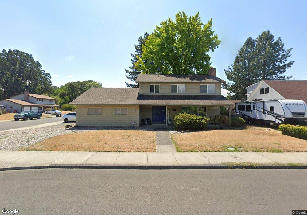
2056 NE Grant St Hillsboro, OR 97124
Central Hillsboro NeighborhoodEstimated Value: $559,076 - $598,000
4
Beds
3
Baths
1,928
Sq Ft
$299/Sq Ft
Est. Value
About This Home
This home is located at 2056 NE Grant St, Hillsboro, OR 97124 and is currently estimated at $575,519, approximately $298 per square foot. 2056 NE Grant St is a home located in Washington County with nearby schools including Eastwood Elementary School, J.W. Poynter Middle School, and Liberty High School.
Ownership History
Date
Name
Owned For
Owner Type
Purchase Details
Closed on
Mar 26, 2014
Sold by
Wynant Kelly R and Wynant Tracy A
Bought by
Wynant Tracy A
Current Estimated Value
Home Financials for this Owner
Home Financials are based on the most recent Mortgage that was taken out on this home.
Original Mortgage
$211,200
Outstanding Balance
$160,005
Interest Rate
4.25%
Mortgage Type
New Conventional
Estimated Equity
$415,514
Purchase Details
Closed on
Jun 12, 1995
Sold by
Helmricks Dale A and Helmricks Lavon L
Bought by
Wynant Kelly R and Wynant Tracy A
Create a Home Valuation Report for This Property
The Home Valuation Report is an in-depth analysis detailing your home's value as well as a comparison with similar homes in the area
Home Values in the Area
Average Home Value in this Area
Purchase History
| Date | Buyer | Sale Price | Title Company |
|---|---|---|---|
| Wynant Tracy A | -- | Amerititle | |
| Wynant Kelly R | $150,000 | Transamerica Title Insurance |
Source: Public Records
Mortgage History
| Date | Status | Borrower | Loan Amount |
|---|---|---|---|
| Open | Wynant Tracy A | $211,200 |
Source: Public Records
Tax History Compared to Growth
Tax History
| Year | Tax Paid | Tax Assessment Tax Assessment Total Assessment is a certain percentage of the fair market value that is determined by local assessors to be the total taxable value of land and additions on the property. | Land | Improvement |
|---|---|---|---|---|
| 2025 | $4,174 | $255,370 | -- | -- |
| 2024 | $4,056 | $247,940 | -- | -- |
| 2023 | $4,056 | $240,720 | $0 | $0 |
| 2022 | $3,946 | $240,720 | $0 | $0 |
| 2021 | $3,866 | $226,910 | $0 | $0 |
| 2020 | $3,783 | $220,310 | $0 | $0 |
| 2019 | $3,674 | $213,900 | $0 | $0 |
| 2018 | $3,517 | $207,670 | $0 | $0 |
| 2017 | $3,390 | $201,630 | $0 | $0 |
| 2016 | $3,297 | $195,760 | $0 | $0 |
| 2015 | $3,164 | $190,060 | $0 | $0 |
| 2014 | $3,146 | $184,530 | $0 | $0 |
Source: Public Records
Map
Nearby Homes
- 2411 NE Hyde St
- 2570 NE Grant St
- 461 NE 16th Ave
- 1822 NE Barberry Dr
- 319 NE Hyde Cir
- 1303 NE Cornell Rd
- 2080 NE Darby St
- 1740 NE Darby St
- 1269 NE Grant St
- 1184 NE Turner Dr
- 1043 NE Sturgess Ave
- 1455 NE Jessica Loop
- 1442 NE 14th Ave
- 1450 NE Sunrise Ln
- 3029 NE Azalea St
- 240 SE 26th Ave
- 1112 E Main St
- 439 SE 24th Ave
- 1518 SE Oak St Unit 2
- 166 SE 30th Ave
- 2020 NE Grant St
- 575 NE 21st Ave
- 2021 NE Jefferson St
- 560 NE 21st Ave
- 1970 NE Grant St
- 2055 NE Grant St
- 590 NE 21st Ave
- 2015 NE Grant St
- 1995 NE Jefferson St
- 630 NE 21st Ave
- 2152 NE Grant St
- 1973 NE Grant St
- 1922 NE Grant St
- 550 NE 21st Ave
- 2048 NE Jefferson St
- 671 NE 21st Ave
- 2002 NE Jefferson St
- 1953 NE Jefferson St
- 2024 NE Poynter St
- 2157 NE Grant St