Estimated Value: $144,496 - $188,000
2
Beds
1
Bath
1,344
Sq Ft
$124/Sq Ft
Est. Value
About This Home
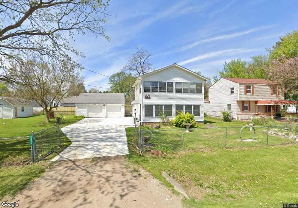
This home is located at 2056 Roslyn Ave, Flint, MI 48532 and is currently estimated at $166,374, approximately $123 per square foot. 2056 Roslyn Ave is a home located in Genesee County with nearby schools including Carman-Ainsworth High School, Genesee STEM Academy, and Genesee Academy.
Ownership History
Date
Name
Owned For
Owner Type
Purchase Details
Closed on
Apr 14, 2011
Sold by
The Pauline Beasley Trust
Bought by
Beasley Holly A
Current Estimated Value
Home Financials for this Owner
Home Financials are based on the most recent Mortgage that was taken out on this home.
Original Mortgage
$43,884
Outstanding Balance
$30,905
Interest Rate
5.25%
Mortgage Type
FHA
Estimated Equity
$135,469
Purchase Details
Closed on
Jun 1, 2005
Sold by
Beasley Pauline
Bought by
Beasley Pauline and Pauline Beasley Trust
Create a Home Valuation Report for This Property
The Home Valuation Report is an in-depth analysis detailing your home's value as well as a comparison with similar homes in the area
Home Values in the Area
Average Home Value in this Area
Purchase History
| Date | Buyer | Sale Price | Title Company |
|---|---|---|---|
| Beasley Holly A | $49,000 | Cislo Title Co | |
| Beasley Pauline | -- | None Available |
Source: Public Records
Mortgage History
| Date | Status | Borrower | Loan Amount |
|---|---|---|---|
| Open | Beasley Holly A | $43,884 |
Source: Public Records
Tax History
| Year | Tax Paid | Tax Assessment Tax Assessment Total Assessment is a certain percentage of the fair market value that is determined by local assessors to be the total taxable value of land and additions on the property. | Land | Improvement |
|---|---|---|---|---|
| 2025 | $2,003 | $61,600 | $0 | $0 |
| 2024 | $1,040 | $54,500 | $0 | $0 |
| 2023 | $993 | $47,900 | $0 | $0 |
| 2022 | $860 | $44,000 | $0 | $0 |
| 2021 | $1,773 | $42,500 | $0 | $0 |
| 2020 | $892 | $42,000 | $0 | $0 |
| 2019 | $879 | $41,700 | $0 | $0 |
| 2018 | $1,648 | $39,600 | $0 | $0 |
| 2017 | $1,578 | $39,600 | $0 | $0 |
| 2016 | $1,618 | $39,500 | $0 | $0 |
| 2015 | $1,476 | $39,500 | $0 | $0 |
| 2014 | $876 | $38,000 | $0 | $0 |
| 2012 | -- | $35,300 | $35,300 | $0 |
Source: Public Records
Map
Nearby Homes
- 000 Corunna Rd
- 00 Corunna Rd
- 6172 W Court St
- 6007 Corunna Rd
- 6272 W Court St
- 1442 Mintola Ave
- 6507 Corunna Rd Unit 6493 Corunna Rd.
- 6090 Lancaster Dr
- 6456 W Court St
- 5423 Meadowcrest Dr
- 1417 Grassmere Ave
- 0000 Corunna Rd
- 5323 Elmsford Dr
- 7035 Saratoga Dr
- 5290 Brobeck St
- 0000 Reuben Reuben St
- 2052 S Dye Rd
- 7030 Saratoga Dr
- 7075 Saratoga Dr
- 1460 S Dye Rd
- 2052 Roslyn Ave
- 2061 Roland Ave
- 2072 Roslyn Ave
- 2053 Roland Ave
- 2073 Roland Ave
- 2046 Roslyn Ave
- 2061 Roslyn Ave
- 2055 Roslyn Ave
- 2065 Roslyn Ave
- 2043 Roland Ave
- 2073 Roslyn Ave
- 2087 Roland Ave
- 2087 Roland Ave
- 2047 Roslyn Ave
- 2075 Roslyn Ave
- 2062 Roland Ave
- 2062 Roland Ave
- 2029 Roland Ave
- 2076 Roland Ave
- 2076 Roland Ave