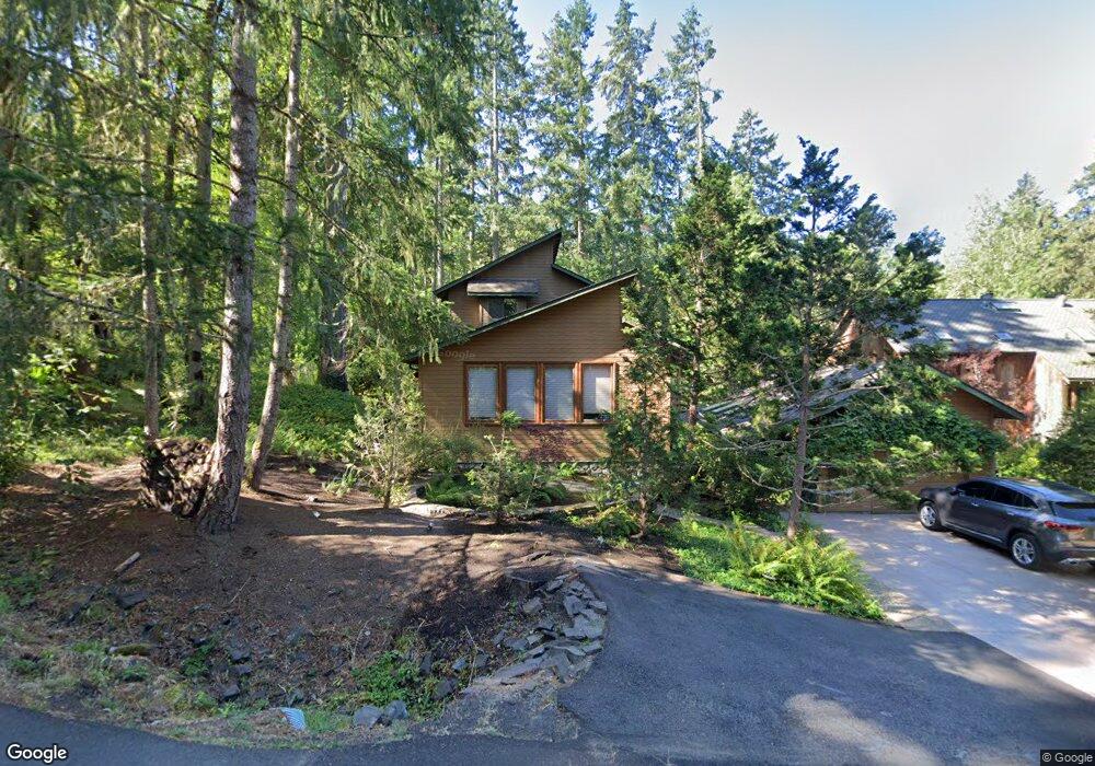
2056 S Shasta Loop Eugene, OR 97405
Southeast Eugene NeighborhoodEstimated Value: $696,178 - $927,000
2
Beds
2
Baths
2,472
Sq Ft
$323/Sq Ft
Est. Value
About This Home
This home is located at 2056 S Shasta Loop, Eugene, OR 97405 and is currently estimated at $797,295, approximately $322 per square foot. 2056 S Shasta Loop is a home located in Lane County with nearby schools including Edgewood Community Elementary School, Spencer Butte Middle School, and South Eugene High School.
Ownership History
Date
Name
Owned For
Owner Type
Purchase Details
Closed on
Oct 16, 2012
Sold by
Williams Rick and Newton Julianne H
Bought by
Williams Fred R and Newton Julianne H
Current Estimated Value
Purchase Details
Closed on
Aug 16, 2000
Sold by
Bernuth Victoria M
Bought by
Williams Rick and Newton Julianne H
Home Financials for this Owner
Home Financials are based on the most recent Mortgage that was taken out on this home.
Original Mortgage
$155,000
Outstanding Balance
$55,189
Interest Rate
8.16%
Estimated Equity
$742,106
Create a Home Valuation Report for This Property
The Home Valuation Report is an in-depth analysis detailing your home's value as well as a comparison with similar homes in the area
Home Values in the Area
Average Home Value in this Area
Purchase History
| Date | Buyer | Sale Price | Title Company |
|---|---|---|---|
| Williams Fred R | -- | None Available | |
| Williams Rick | $294,900 | Western Pioneer Title Co |
Source: Public Records
Mortgage History
| Date | Status | Borrower | Loan Amount |
|---|---|---|---|
| Open | Williams Rick | $155,000 |
Source: Public Records
Tax History
| Year | Tax Paid | Tax Assessment Tax Assessment Total Assessment is a certain percentage of the fair market value that is determined by local assessors to be the total taxable value of land and additions on the property. | Land | Improvement |
|---|---|---|---|---|
| 2025 | $7,623 | $391,270 | -- | -- |
| 2024 | $7,529 | $379,874 | -- | -- |
| 2023 | $7,529 | $368,810 | $0 | $0 |
| 2022 | $7,053 | $358,068 | $0 | $0 |
| 2021 | $6,624 | $347,639 | $0 | $0 |
| 2020 | $6,648 | $337,514 | $0 | $0 |
| 2019 | $6,420 | $327,684 | $0 | $0 |
| 2018 | $6,044 | $308,874 | $0 | $0 |
| 2017 | $5,745 | $308,874 | $0 | $0 |
| 2016 | $5,430 | $299,878 | $0 | $0 |
| 2015 | $5,208 | $291,144 | $0 | $0 |
| 2014 | $5,145 | $282,664 | $0 | $0 |
Source: Public Records
Map
Nearby Homes
- 0 Why Worry Ln
- 1862 E 43rd Ave
- 2015 E 43rd Ave
- 1865 E 43rd Ave
- 1755 E 43rd Ave
- 0 Spring Blvd Unit 499589777
- 0 Wendell Ln Unit 200453475
- 0 Wendell Ln Unit 279865930
- 0 Wendell Ln Unit 1
- 0
- 4835 Elva Ln
- 4080 Spring Blvd
- 4733 E Amazon Dr
- 4015 Spring Knoll Dr
- 892 Sprague St
- 0 N Shasta Loop Unit 384285834
- 3945 Spring Blvd
- 4429 Fox Hollow Rd Unit 3
- 4680 W Hillside Dr
- 910 E 43rd Ave
- 2052 S Shasta Loop
- 1415 Skyline Park Loop
- 2044 S Shasta Loop
- 1405 Skyline Park Loop
- 2040 S Shasta Loop
- 4690 Crescent Ridge Ln
- 1395 Skyline Park Loop
- 4680 Crescent Ridge Ln
- 2041 S Shasta Loop
- 4660 Crescent Ridge Ln
- 4698 Crescent Ridge Ln
- 2036 S Shasta Loop
- 4650 Crescent Ridge Ln
- 1385 Skyline Park Loop
- 4675 Crescent Ridge Ln
- 4630 Crescent Ridge Ln
- 2030 S Shasta Loop
- 4645 Crescent Ridge Ln
- 4620 Crescent Ridge Ln
- 1345 Skyline Park Loop
Your Personal Tour Guide
Ask me questions while you tour the home.