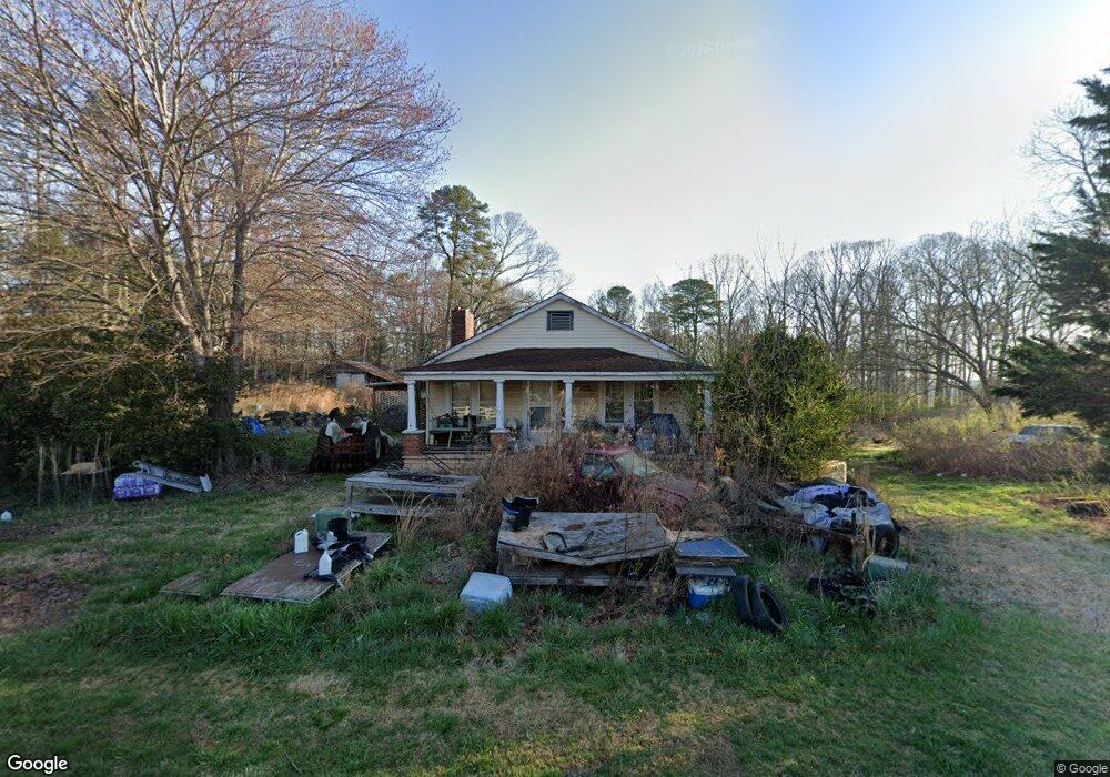
2057 Toccoa Hwy Mount Airy, GA 30563
Estimated Value: $199,000 - $291,000
2
Beds
1
Bath
1,424
Sq Ft
$184/Sq Ft
Est. Value
About This Home
This home is located at 2057 Toccoa Hwy, Mount Airy, GA 30563 and is currently estimated at $262,190, approximately $184 per square foot. 2057 Toccoa Hwy is a home located in Habersham County with nearby schools including Demorest Elementary School, Habersham Success Academy, and Wilbanks Middle School.
Ownership History
Date
Name
Owned For
Owner Type
Purchase Details
Closed on
Feb 22, 2021
Sold by
Executor Kellogg Sherri Lynn
Bought by
Franklin Jeffrey Terrell
Current Estimated Value
Purchase Details
Closed on
Feb 5, 2021
Sold by
Smith Michele
Bought by
Franklin Jeffrey Terrell
Purchase Details
Closed on
Oct 4, 2019
Sold by
Franklin Alfred
Bought by
Franklin G Terrell
Purchase Details
Closed on
Aug 23, 2012
Sold by
Scbt
Bought by
Franklin Alfred
Create a Home Valuation Report for This Property
The Home Valuation Report is an in-depth analysis detailing your home's value as well as a comparison with similar homes in the area
Home Values in the Area
Average Home Value in this Area
Purchase History
| Date | Buyer | Sale Price | Title Company |
|---|---|---|---|
| Franklin Jeffrey Terrell | -- | -- | |
| Franklin Jeffrey Terrell | -- | -- | |
| Franklin Jeffrey Terrell | -- | -- | |
| Franklin G Terrell | $92,000 | -- | |
| Franklin Alfred | -- | -- |
Source: Public Records
Tax History Compared to Growth
Tax History
| Year | Tax Paid | Tax Assessment Tax Assessment Total Assessment is a certain percentage of the fair market value that is determined by local assessors to be the total taxable value of land and additions on the property. | Land | Improvement |
|---|---|---|---|---|
| 2025 | $254 | $105,217 | $64,731 | $40,486 |
| 2024 | -- | $73,140 | $43,880 | $29,260 |
| 2023 | $43 | $68,260 | $43,880 | $24,380 |
| 2022 | $253 | $67,768 | $46,760 | $21,008 |
| 2021 | $226 | $59,792 | $40,916 | $18,876 |
| 2020 | $224 | $57,236 | $40,916 | $16,320 |
| 2019 | $1,479 | $54,928 | $38,396 | $16,532 |
| 2018 | $1,467 | $54,928 | $38,396 | $16,532 |
| 2017 | $1,443 | $53,748 | $38,396 | $15,352 |
| 2016 | $1,258 | $120,660 | $32,912 | $15,352 |
| 2015 | $1,244 | $120,660 | $32,912 | $15,352 |
| 2014 | $1,263 | $120,300 | $32,912 | $15,208 |
| 2013 | -- | $48,120 | $32,912 | $15,208 |
Source: Public Records
Map
Nearby Homes
- 268 Northwoods Dr
- 2207 Blacksnake Rd
- 1605 Cody Rd
- 0 Gladston Rd
- 372 Abbington Way
- 849 Blacksnake Rd
- 1116 Cody Rd
- 441 Expressway
- 281 Abbington Way
- 315 Glade Rock Springs Rd
- 222 N Mize Rd
- 192 Stonington Dr
- 409 Roper Dr
- 405 Roper Dr
- 2171 Hollywood Hwy
- 0 S Highway 365 Unit 10006827
- 0 Buckhorn Rd Unit 10556339
- 281 Grindstone Creek Dr
- 278 Oakwood Place
- 253 Grindstone Creek Dr
- 134 Hatfield Trail
- 140 Hatfield Trail
- 2552 Georgia 17
- 0 Hatfield Trail Unit 8462888
- 0 Hatfield Trail
- 2084 Toccoa Hwy
- 202 Hatfield Trail
- 1968 Toccoa Hwy
- 1892 Toccoa Hwy
- 373 Hatfield Trail
- 1813 Toccoa Hwy
- 1954 Toccoa Hwy
- 1850 Toccoa Hwy
- 2252 Toccoa Hwy
- 1776 Toccoa Hwy
- 322 Franklin Rd
- 152 Franklin Rd
- 340 Franklin Rd
- 394 Franklin Rd
- 271 Franklin Rd