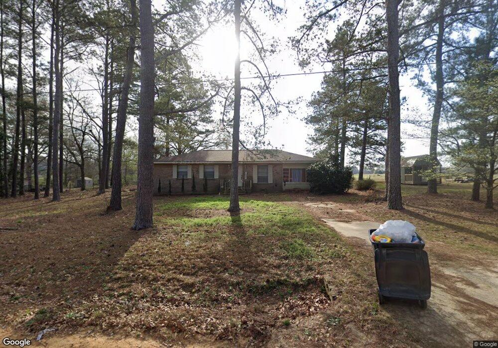
2058 Byrd Rd Thomson, GA 30824
Estimated Value: $160,012 - $241,000
3
Beds
2
Baths
1,429
Sq Ft
$143/Sq Ft
Est. Value
About This Home
This home is located at 2058 Byrd Rd, Thomson, GA 30824 and is currently estimated at $203,753, approximately $142 per square foot. 2058 Byrd Rd is a home located in McDuffie County with nearby schools including Thomson High School.
Ownership History
Date
Name
Owned For
Owner Type
Purchase Details
Closed on
May 31, 2007
Sold by
Anderson Musa J
Bought by
Sims Stephanie C
Current Estimated Value
Home Financials for this Owner
Home Financials are based on the most recent Mortgage that was taken out on this home.
Original Mortgage
$96,272
Outstanding Balance
$57,824
Interest Rate
6.12%
Mortgage Type
FHA
Estimated Equity
$145,929
Purchase Details
Closed on
Aug 14, 1975
Bought by
Anderson Jut L
Create a Home Valuation Report for This Property
The Home Valuation Report is an in-depth analysis detailing your home's value as well as a comparison with similar homes in the area
Home Values in the Area
Average Home Value in this Area
Purchase History
| Date | Buyer | Sale Price | Title Company |
|---|---|---|---|
| Sims Stephanie C | $97,800 | -- | |
| Anderson Jut L | -- | -- |
Source: Public Records
Mortgage History
| Date | Status | Borrower | Loan Amount |
|---|---|---|---|
| Open | Sims Stephanie C | $96,272 |
Source: Public Records
Tax History Compared to Growth
Tax History
| Year | Tax Paid | Tax Assessment Tax Assessment Total Assessment is a certain percentage of the fair market value that is determined by local assessors to be the total taxable value of land and additions on the property. | Land | Improvement |
|---|---|---|---|---|
| 2025 | $1,016 | $45,743 | $2,441 | $43,302 |
| 2024 | $1,016 | $42,717 | $2,199 | $40,518 |
| 2023 | $977 | $41,053 | $2,199 | $38,854 |
| 2022 | $773 | $31,369 | $2,199 | $29,170 |
| 2021 | $587 | $24,425 | $1,535 | $22,890 |
| 2020 | $664 | $27,548 | $2,192 | $25,356 |
| 2019 | $671 | $27,548 | $2,192 | $25,356 |
| 2018 | $907 | $35,822 | $2,192 | $33,630 |
| 2017 | $875 | $35,822 | $2,192 | $33,630 |
| 2016 | $875 | $35,822 | $2,192 | $33,630 |
| 2015 | $813 | $36,456 | $2,826 | $33,630 |
| 2014 | $815 | $36,456 | $2,826 | $33,630 |
| 2013 | -- | $36,456 | $2,826 | $33,630 |
Source: Public Records
Map
Nearby Homes
- 651 Moose Club Rd
- 1463 Lokey Dr
- 1086 Boneville Rd
- 1076 Boneville Rd
- 338 Devonshire Dr
- 219 Devonshire Dr
- 2592 White Oak Rd
- A-00 Harrison Rd
- 146 Willow Oak Cir
- 137 Willow Oak Cir
- 122 Willow Oak Cir
- 123 Willow Oak Cir
- 125 Willow Oak Cir
- 0 Randall Hunt Rd Unit 24088941
- 563 Lakewood Dr
- 789 George McDuffie Rd
- 2145 April Dawn Trail
- 2133 April Dawn Trail
- 2123 April Dawn Trail
- 2043 Byrd Rd
- 2080 Byrd Rd
- 2089 Byrd Rd
- 2089 Byrd Rd
- 2025 Byrd Rd
- 1200 Moose Club Rd
- 1158 Moose Club Rd
- 1214 Moose Club Rd
- 1280 Randall Hunt Rd
- 1238 Moose Club Rd
- 0 Moose Club Rd
- 917 Margarets Rd
- 1159 Moose Club Rd
- 919 Margarets Rd
- 1340 Randall Hunt Rd
- 1257 Moose Club Rd
- 1331 Randall Hunt Rd
- 1173 Moose Club Rd
- 1300 Moose Club Rd
- 901 Margarets Rd