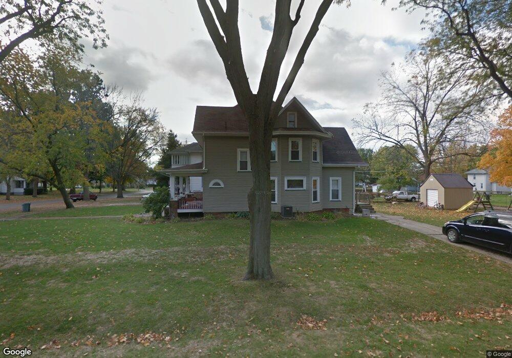
206 N Swarts Ave Abingdon, IL 61410
Estimated Value: $108,000 - $112,000
3
Beds
2
Baths
2,136
Sq Ft
$52/Sq Ft
Est. Value
About This Home
This home is located at 206 N Swarts Ave, Abingdon, IL 61410 and is currently estimated at $110,666, approximately $51 per square foot. 206 N Swarts Ave is a home located in Knox County with nearby schools including Hedding Grade School, Avon Elementary School, and Abingdon-Avon Middle School.
Ownership History
Date
Name
Owned For
Owner Type
Purchase Details
Closed on
Apr 24, 2023
Sold by
Wilson Randy L
Bought by
Mcgowan Teresa
Current Estimated Value
Purchase Details
Closed on
May 18, 2012
Sold by
Franklin Steven N
Bought by
Wilson Randy L
Home Financials for this Owner
Home Financials are based on the most recent Mortgage that was taken out on this home.
Original Mortgage
$79,081
Interest Rate
4%
Mortgage Type
New Conventional
Create a Home Valuation Report for This Property
The Home Valuation Report is an in-depth analysis detailing your home's value as well as a comparison with similar homes in the area
Home Values in the Area
Average Home Value in this Area
Purchase History
| Date | Buyer | Sale Price | Title Company |
|---|---|---|---|
| Mcgowan Teresa | $92,000 | Attorney Only | |
| Wilson Randy L | $75,000 | Attorney Only |
Source: Public Records
Mortgage History
| Date | Status | Borrower | Loan Amount |
|---|---|---|---|
| Previous Owner | Wilson Randy L | $79,081 |
Source: Public Records
Tax History Compared to Growth
Tax History
| Year | Tax Paid | Tax Assessment Tax Assessment Total Assessment is a certain percentage of the fair market value that is determined by local assessors to be the total taxable value of land and additions on the property. | Land | Improvement |
|---|---|---|---|---|
| 2024 | $2,236 | $33,430 | $2,640 | $30,790 |
| 2023 | $2,236 | $30,170 | $2,380 | $27,790 |
| 2022 | $1,993 | $28,670 | $2,260 | $26,410 |
| 2021 | $1,935 | $27,560 | $2,170 | $25,390 |
| 2020 | $1,849 | $26,500 | $2,090 | $24,410 |
| 2019 | $1,896 | $26,240 | $2,070 | $24,170 |
| 2018 | $1,828 | $25,480 | $2,010 | $23,470 |
| 2017 | $1,800 | $24,980 | $1,970 | $23,010 |
| 2015 | -- | $24,490 | $1,930 | $22,560 |
| 2013 | $832 | $24,250 | $1,910 | $22,340 |
Source: Public Records
Map
Nearby Homes
- 103 N Swarts St
- 407 W Martin St
- 108 W Jackson St
- 500 N Monroe St
- 204 S Washington St
- 106 E Jackson St
- 214 S Main St
- 206 W Lower St
- 211 S Froelich Ln
- 204 E Adams St
- 306 N Harshbarger St
- 704 N Cherry St
- 405 W Memorial Dr
- 205 N Austin Ave
- 103 W Givens St
- 403 1/2 E Jared St
- 369 Knox Highway 23
- 1196 160th St
- 1077 Knox Road 500 E
- 572 Knox Highway 26
- 206 N Swarts St
- 204 N Swarts Ave
- 202 N Swarts Ave
- 202 N Swarts St
- 300 N Swarts Ave
- 207 N Pennsylvania St
- 205 N Pennsylvania St
- 409 W Pearl St
- 200 N Swarts Ave
- 302 N Swarts Ave
- 207 N Swarts Ave
- 203 N Pennsylvania St
- 205 N Swarts Ave
- 309 W Pearl St
- 203 N Swarts Ave
- 201 N Pennsylvania St
- 301 N Pennsylvania St
- 303 N Pennsylvania St
- 304 N Swarts Ave
- 307 W Pearl St