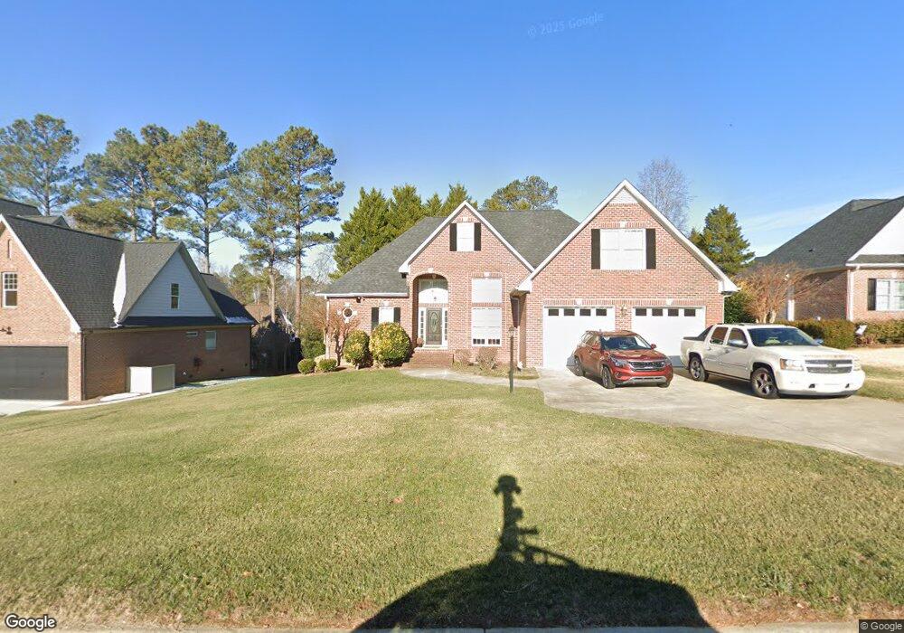
206 Par Dr Henderson, NC 27536
Estimated Value: $363,817 - $466,000
3
Beds
2
Baths
2,228
Sq Ft
$184/Sq Ft
Est. Value
About This Home
This home is located at 206 Par Dr, Henderson, NC 27536 and is currently estimated at $409,454, approximately $183 per square foot. 206 Par Dr is a home located in Vance County with nearby schools including E.M. Rollins Elementary School, Vance County High School, and Vance Charter School.
Ownership History
Date
Name
Owned For
Owner Type
Purchase Details
Closed on
Mar 22, 2018
Sold by
Blackwell Elizabeth and Stancil Elizabeth S
Bought by
Eskin Glenn and Eskin Andrea
Current Estimated Value
Home Financials for this Owner
Home Financials are based on the most recent Mortgage that was taken out on this home.
Original Mortgage
$165,000
Outstanding Balance
$141,190
Interest Rate
4.32%
Mortgage Type
New Conventional
Estimated Equity
$268,264
Purchase Details
Closed on
Oct 1, 2001
Bought by
Stancil Elizabeth S
Create a Home Valuation Report for This Property
The Home Valuation Report is an in-depth analysis detailing your home's value as well as a comparison with similar homes in the area
Purchase History
| Date | Buyer | Sale Price | Title Company |
|---|---|---|---|
| Eskin Glenn | $220,000 | None Available | |
| Stancil Elizabeth S | $214,000 | -- |
Source: Public Records
Mortgage History
| Date | Status | Borrower | Loan Amount |
|---|---|---|---|
| Open | Eskin Glenn | $165,000 |
Source: Public Records
Tax History
| Year | Tax Paid | Tax Assessment Tax Assessment Total Assessment is a certain percentage of the fair market value that is determined by local assessors to be the total taxable value of land and additions on the property. | Land | Improvement |
|---|---|---|---|---|
| 2025 | $4,660 | $331,207 | $10,800 | $320,407 |
| 2024 | $4,639 | $331,207 | $10,800 | $320,407 |
| 2023 | $3,683 | $217,267 | $30,000 | $187,267 |
| 2022 | $3,601 | $217,267 | $30,000 | $187,267 |
| 2021 | $3,481 | $217,267 | $30,000 | $187,267 |
| 2020 | $3,598 | $217,267 | $30,000 | $187,267 |
| 2019 | $3,593 | $217,267 | $30,000 | $187,267 |
| 2018 | $3,481 | $217,267 | $30,000 | $187,267 |
| 2017 | $3,586 | $217,267 | $30,000 | $187,267 |
| 2016 | $3,586 | $217,267 | $30,000 | $187,267 |
| 2015 | $3,386 | $241,400 | $32,000 | $209,400 |
| 2014 | $3,514 | $241,412 | $32,000 | $209,412 |
Source: Public Records
Map
Nearby Homes
- 204 Par Dr
- 1806 Waddill Way
- 1630 Ruin Creek Rd
- 1822 Ruin Creek Rd
- 2535 Fairway Dr Unit 3
- Lot 5 Sidney Hill
- 1612 Lynne Ave
- 119 Deer Wood Trail
- 1105 Dabney Dr
- 206 Beechwood Trail
- 1220 Roanoke Ave
- 1204 Roanoke Ave
- 1540 Cypress Dr
- 1408 Parker Ln
- 126 White Oak Dr
- 131 White Oak Dr
- 00 Oxford Rd Southern Ave Rd
- 314 Willowood Dr
- 307 Yowland Rd
- 105 Sunset Cir
- 202 Par Dr
- 208 Par Dr
- Lot 27 Par Dr
- 0 Par Dr Unit 1799655
- 0 Par Dr Unit 1799650
- 0 Par Dr Unit 31 TR1799650
- 0 Par Dr Unit 41 TR1799655
- Lot 31 Par Dr Unit 31
- Lot 41 Par Dr Unit 41
- Lot 31 Par Dr
- Lot 41 Par Dr
- Lot 18 Par Dr
- 411 Eagle Ct
- 403 Eagle Ct
- 413 Eagle Ct
- 210 Par Dr
- 209 Par Dr
- 207 Par Dr
- 405 Eagle Ct
- 211 Par Dr
Your Personal Tour Guide
Ask me questions while you tour the home.