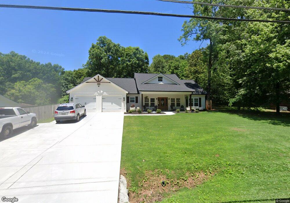
206 Rips Rd Calhoun, GA 30701
Estimated Value: $401,000 - $434,029
3
Beds
2
Baths
2,597
Sq Ft
$161/Sq Ft
Est. Value
About This Home
This home is located at 206 Rips Rd, Calhoun, GA 30701 and is currently estimated at $419,257, approximately $161 per square foot. 206 Rips Rd is a home located in Gordon County with nearby schools including Belwood Elementary School and Philadelphia Christian School.
Ownership History
Date
Name
Owned For
Owner Type
Purchase Details
Closed on
Jan 19, 2023
Sold by
W Harrison Unlimited Llc
Bought by
Mosac Thomas Michael and Mosac Stephanie Marie
Current Estimated Value
Purchase Details
Closed on
Nov 1, 2021
Sold by
Horner Billy Martin
Bought by
W Harrison Unlimited Llc
Purchase Details
Closed on
Aug 5, 2021
Sold by
Horner Billy Martin
Bought by
Horner Billy Martin and Gentry Linda
Purchase Details
Closed on
Apr 13, 1965
Bought by
Barton Trammell J
Create a Home Valuation Report for This Property
The Home Valuation Report is an in-depth analysis detailing your home's value as well as a comparison with similar homes in the area
Home Values in the Area
Average Home Value in this Area
Purchase History
| Date | Buyer | Sale Price | Title Company |
|---|---|---|---|
| Mosac Thomas Michael | $385,000 | -- | |
| W Harrison Unlimited Llc | $60,000 | -- | |
| Horner Billy Martin | -- | -- | |
| Horner Billy Martin | $140,000 | -- | |
| Barton Trammell J | -- | -- |
Source: Public Records
Tax History Compared to Growth
Tax History
| Year | Tax Paid | Tax Assessment Tax Assessment Total Assessment is a certain percentage of the fair market value that is determined by local assessors to be the total taxable value of land and additions on the property. | Land | Improvement |
|---|---|---|---|---|
| 2024 | $3,552 | $141,800 | $8,800 | $133,000 |
| 2023 | $3,066 | $120,680 | $8,800 | $111,880 |
| 2022 | $238 | $8,800 | $8,800 | $0 |
| 2021 | $224 | $8,000 | $8,000 | $0 |
| 2020 | $167 | $5,840 | $5,840 | $0 |
| 2019 | $168 | $5,840 | $5,840 | $0 |
| 2018 | $132 | $4,600 | $4,600 | $0 |
| 2017 | $123 | $4,160 | $4,160 | $0 |
| 2016 | $124 | $4,160 | $4,160 | $0 |
| 2015 | $148 | $4,920 | $4,920 | $0 |
| 2014 | $144 | $4,928 | $4,928 | $0 |
Source: Public Records
Map
Nearby Homes
- 199 Cherry St SE
- 408 Peters St
- 119 Deer Park Ln
- 402 Linda Ln
- 0 Deer Park Ln Unit 10659841
- 0 Deer Park Ln Unit 7692335
- 306 E Belmont Dr
- 119 Telfair St
- 111 Lewis Dr SE
- 128 Victor St
- 0 W Belmont Dr Unit 10489910
- 1311 Us Highway 41
- The Pearson Plan at Laurel Creek
- The Coleman Plan at Laurel Creek
- The Benson II Plan at Laurel Creek
- The Piedmont Plan at Laurel Creek
- The Harrington Plan at Laurel Creek
- The McGinnis Plan at Laurel Creek
- The Caldwell Plan at Laurel Creek
- 114 Vinings Way SE