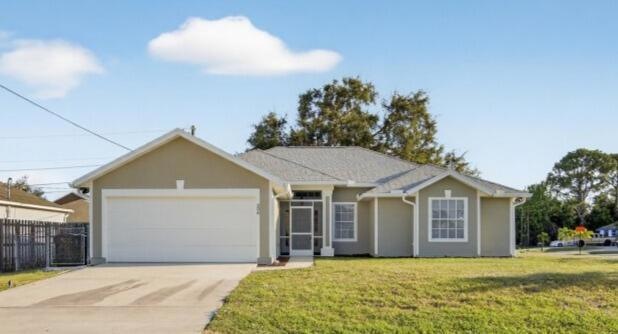
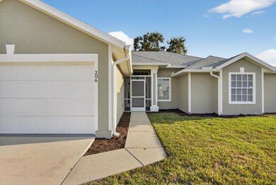
206 SW Kestor Dr Port Saint Lucie, FL 34953
Becker Ridge NeighborhoodEstimated payment $2,226/month
Highlights
- 2 Car Attached Garage
- Central Heating and Cooling System
- Vinyl Flooring
- Separate Shower in Primary Bathroom
- Family Room
- 1-Story Property
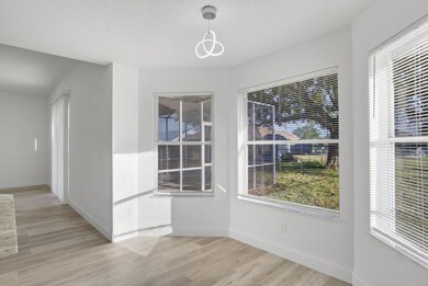
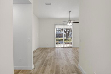
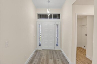
About This Home
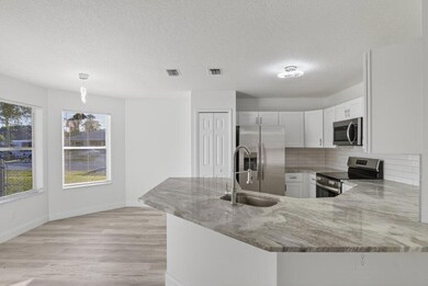
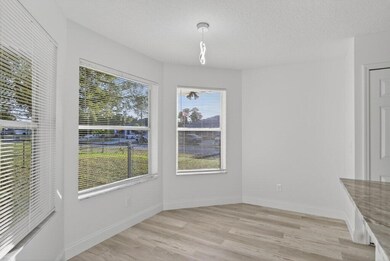
Nicely Renovated 3 bedroom 2 bath 2 car garage CBS home in Port St. Lucie. This home features an updated kitchen with solid wood cabinets, granite tops and stainless steel appliances. New flooring throughout. Both bathrooms have been updated. All new light fixtures and fans throughout. Roof is from 2018 and HVAC is from 2023. Move in ready!
Home Details
Home Type
- Single Family
Est. Annual Taxes
- $1,362
Year Built
- Built in 1996
Lot Details
- 10,454 Sq Ft Lot
- Property is zoned RS-2PS
Parking
- 2 Car Attached Garage
Home Design
- Shingle Roof
- Composition Roof
Interior Spaces
- 1,457 Sq Ft Home
- 1-Story Property
- Family Room
- Vinyl Flooring
Kitchen
- Electric Range
- Microwave
- Dishwasher
Bedrooms and Bathrooms
- 3 Bedrooms | 2 Main Level Bedrooms
- Split Bedroom Floorplan
- 2 Full Bathrooms
- Separate Shower in Primary Bathroom
Utilities
- Central Heating and Cooling System
- Septic Tank
Community Details
- Port St Lucie Section 34 Subdivision
Listing and Financial Details
- Assessor Parcel Number 342066522360009
Map
Home Values in the Area
Average Home Value in this Area
Tax History
| Year | Tax Paid | Tax Assessment Tax Assessment Total Assessment is a certain percentage of the fair market value that is determined by local assessors to be the total taxable value of land and additions on the property. | Land | Improvement |
|---|---|---|---|---|
| 2024 | $1,239 | $77,839 | -- | -- |
| 2023 | $1,239 | $75,572 | $0 | $0 |
| 2022 | $1,262 | $73,371 | $0 | $0 |
| 2021 | $1,185 | $71,234 | $0 | $0 |
| 2020 | $1,420 | $70,251 | $0 | $0 |
| 2019 | $1,424 | $68,672 | $0 | $0 |
| 2018 | $1,374 | $67,392 | $0 | $0 |
| 2017 | $1,378 | $125,500 | $29,800 | $95,700 |
| 2016 | $1,377 | $109,400 | $25,500 | $83,900 |
| 2015 | $1,387 | $86,800 | $17,000 | $69,800 |
| 2014 | $1,350 | $63,690 | $0 | $0 |
Property History
| Date | Event | Price | List to Sale | Price per Sq Ft |
|---|---|---|---|---|
| 11/26/2025 11/26/25 | For Sale | $399,900 | -- | $274 / Sq Ft |
Purchase History
| Date | Type | Sale Price | Title Company |
|---|---|---|---|
| Warranty Deed | $225,000 | Old Tampa Bay Title | |
| Warranty Deed | $225,000 | Old Tampa Bay Title | |
| Warranty Deed | $5,900 | -- |
Mortgage History
| Date | Status | Loan Amount | Loan Type |
|---|---|---|---|
| Previous Owner | $76,000 | No Value Available |
Source: BeachesMLS
MLS Number: R11143772
APN: 34-20-665-2236-0009
Disclaimer: Certain information contained herein is derived from information provided by parties other than Homes.com. All information provided is deemed reliable, but is not guaranteed to be accurate and should be independently verified.
![]() IDX information is provided exclusively for personal, non-commercial use, and may not be used for any purpose other than to identify prospective properties consumers may be interested in purchasing. Information is deemed reliable but not guaranteed.
IDX information is provided exclusively for personal, non-commercial use, and may not be used for any purpose other than to identify prospective properties consumers may be interested in purchasing. Information is deemed reliable but not guaranteed.
- 221 SW Kestor Dr
- 228 SW Kestor Dr
- 272 SW Glen Rd
- 242 SW Glen Rd
- 4353 SW Otto Ct
- 200 SW Ridgecrest Dr
- 148 SW Sea Lion Rd
- 158 SW Sea Lion Rd
- 4468 SW Athena Dr
- 115 SW South Wakefield Cir
- 4242 SW Muncie St
- 4191 SW MacAd St
- 4535 SW Sw Fireside Cir
- 103 SW Pilsner Cir
- 4588 SW Athena Dr
- 230 SW Ridgecrest Dr
- 4164 SW Webb St
- 4280 SW Darwin Blvd
- 398 SW Ryan Ave
- 156 SW Saratoga Ave
- 174 SW Sea Lion Rd
- 4310 SW Darwin Blvd
- 116 SW Ridgecrest Dr Unit A
- 4397 SW Calah Cir
- 464 SW Balfour Ave
- 284 SW North Quick Cir
- 438 SW Naftal Place
- 371 SW Aero Cir
- 379 SW Jeanne Ave
- 242 SW South Quick Cir
- 391 SW Millard Dr
- 341 SW Kestor Dr Unit 341
- 392 SW Kane Ave
- 467 SW Jeanne Ave
- 4209 SW Whitebread Rd
- 4657 SW Leeward St
- 356 SW Fig Ave
- 499 SW Laconic Ave
- 519 SW Laconic Ave
- 560 SW Nagle Place
