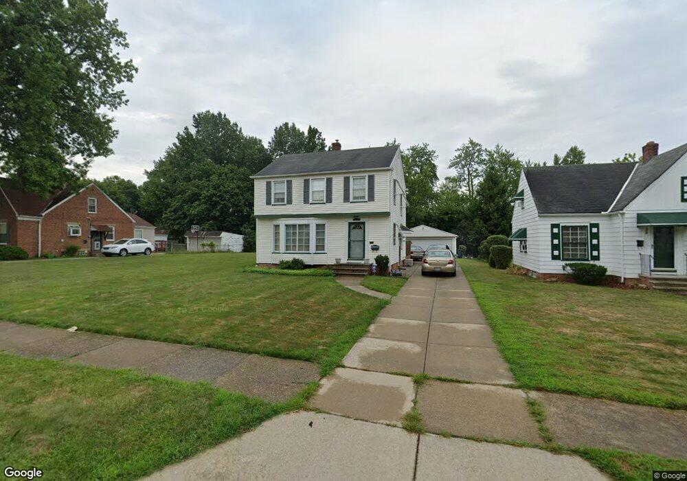
20610 Amherst Rd Beachwood, OH 44122
Estimated Value: $154,000 - $203,000
4
Beds
2
Baths
1,897
Sq Ft
$99/Sq Ft
Est. Value
About This Home
This home is located at 20610 Amherst Rd, Beachwood, OH 44122 and is currently estimated at $187,824, approximately $99 per square foot. 20610 Amherst Rd is a home located in Cuyahoga County with nearby schools including John Dewey Elementary School, Warrensville Heights Middle School, and Warrensville Heights High School.
Ownership History
Date
Name
Owned For
Owner Type
Purchase Details
Closed on
Jun 9, 1993
Sold by
Stover Mary Margaret
Bought by
Howard Odell
Current Estimated Value
Purchase Details
Closed on
Oct 18, 1976
Sold by
Thurston Charles H and Thurston Ella
Bought by
Stover Mary Margaret
Purchase Details
Closed on
Jan 1, 1975
Bought by
Thurston Charles H and Thurston Ella
Create a Home Valuation Report for This Property
The Home Valuation Report is an in-depth analysis detailing your home's value as well as a comparison with similar homes in the area
Home Values in the Area
Average Home Value in this Area
Purchase History
| Date | Buyer | Sale Price | Title Company |
|---|---|---|---|
| Howard Odell | -- | -- | |
| Stover Mary Margaret | $33,900 | -- | |
| Thurston Charles H | -- | -- |
Source: Public Records
Mortgage History
| Date | Status | Borrower | Loan Amount |
|---|---|---|---|
| Open | Stover Mary M | $79,500 |
Source: Public Records
Tax History Compared to Growth
Tax History
| Year | Tax Paid | Tax Assessment Tax Assessment Total Assessment is a certain percentage of the fair market value that is determined by local assessors to be the total taxable value of land and additions on the property. | Land | Improvement |
|---|---|---|---|---|
| 2024 | $3,075 | $57,785 | $8,155 | $49,630 |
| 2023 | $2,043 | $33,640 | $6,270 | $27,370 |
| 2022 | $2,090 | $33,635 | $6,265 | $27,370 |
| 2021 | $2,054 | $33,640 | $6,270 | $27,370 |
| 2020 | $1,889 | $28,740 | $5,360 | $23,380 |
| 2019 | $1,846 | $82,100 | $15,300 | $66,800 |
| 2018 | $1,786 | $28,740 | $5,360 | $23,380 |
| 2017 | $1,749 | $27,300 | $3,780 | $23,520 |
| 2016 | $1,725 | $27,300 | $3,780 | $23,520 |
| 2015 | $2,037 | $27,300 | $3,780 | $23,520 |
| 2014 | $2,037 | $31,750 | $4,380 | $27,370 |
Source: Public Records
Map
Nearby Homes
- 20516 Amherst Rd
- 20511 Balfour Rd
- 3905 Warrensville Center Rd
- 20614 Kings Hwy
- 19912 Lanbury Ave
- 19901 Lanbury Ave
- 20715 E Ridgewood Ave
- 4043 Township Pkwy
- 19819 Harvard Ave
- 3676 Rawnsdale Rd
- 3651 Rawnsdale Rd
- 19615 Harvard Ave
- 19302 Shakerwood Rd
- 3696 Tolland Rd
- 19110 Lanbury Ave
- 19207 Kings Hwy
- 3635 Tolland Rd
- 19112 Kings Hwy
- 19207 Harvard Ave
- 3609 Stoer Rd
- 20606 Amherst Rd
- 20614 Amherst Rd
- 20600 Amherst Rd
- 20704 Amherst Rd
- 20609 Balfour Rd
- 20605 Balfour Rd
- 20611 Balfour Rd
- 20601 Balfour Rd
- 20615 Balfour Rd
- 20512 Amherst Rd
- 20710 Amherst Rd
- 20515 Balfour Rd
- 20619 Balfour Rd
- 20609 Amherst Rd
- 20605 Amherst Rd
- 20615 Amherst Rd
- 20601 Amherst Rd
- 20619 Amherst Rd
- 20714 Amherst Rd
- 20703 Balfour Rd