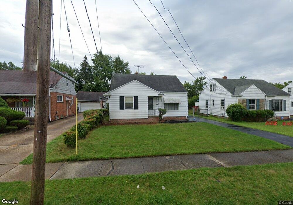
20644 Applegate Rd Maple Heights, OH 44137
Estimated Value: $108,000 - $134,000
3
Beds
1
Bath
832
Sq Ft
$143/Sq Ft
Est. Value
About This Home
This home is located at 20644 Applegate Rd, Maple Heights, OH 44137 and is currently estimated at $118,683, approximately $142 per square foot. 20644 Applegate Rd is a home located in Cuyahoga County with nearby schools including Abraham Lincoln Elementary School, Rockside/ J.F. Kennedy School, and Barack Obama School.
Ownership History
Date
Name
Owned For
Owner Type
Purchase Details
Closed on
Dec 30, 1992
Sold by
Galaska Andrew J
Bought by
Spencer Deborah Y
Current Estimated Value
Purchase Details
Closed on
Jan 25, 1985
Sold by
Burke Ann D
Bought by
Galaska Andrew J
Purchase Details
Closed on
Jun 27, 1984
Sold by
Burke William P
Bought by
Burke Ann D
Purchase Details
Closed on
Mar 16, 1976
Sold by
Burke Wm P and Burke Ann D
Bought by
Burke William P
Purchase Details
Closed on
Jan 1, 1975
Bought by
Burke Wm P and Burke Ann D
Create a Home Valuation Report for This Property
The Home Valuation Report is an in-depth analysis detailing your home's value as well as a comparison with similar homes in the area
Home Values in the Area
Average Home Value in this Area
Purchase History
| Date | Buyer | Sale Price | Title Company |
|---|---|---|---|
| Spencer Deborah Y | $64,900 | -- | |
| Galaska Andrew J | $46,600 | -- | |
| Burke Ann D | -- | -- | |
| Burke William P | -- | -- | |
| Burke Wm P | -- | -- |
Source: Public Records
Tax History
| Year | Tax Paid | Tax Assessment Tax Assessment Total Assessment is a certain percentage of the fair market value that is determined by local assessors to be the total taxable value of land and additions on the property. | Land | Improvement |
|---|---|---|---|---|
| 2024 | $2,724 | $40,250 | $7,000 | $33,250 |
| 2023 | $1,686 | $24,680 | $4,620 | $20,060 |
| 2022 | $1,718 | $24,675 | $4,620 | $20,055 |
| 2021 | $1,943 | $24,680 | $4,620 | $20,060 |
| 2020 | $2,383 | $18,690 | $3,500 | $15,190 |
| 2019 | $2,369 | $53,400 | $10,000 | $43,400 |
| 2018 | $2,357 | $18,690 | $3,500 | $15,190 |
| 2017 | $2,437 | $19,010 | $3,470 | $15,540 |
| 2016 | $2,356 | $19,010 | $3,470 | $15,540 |
| 2015 | $2,366 | $19,010 | $3,470 | $15,540 |
| 2014 | $2,366 | $20,900 | $3,820 | $17,080 |
Source: Public Records
Map
Nearby Homes
- 339 Grand Blvd
- 19113 Watercrest Ave
- 123 Willard Ave
- 54 Willard Ave
- 419 Center Rd
- 66 Hubbell Way
- 58 Hubbell Way
- 62 Hubbell Way
- 54 Hubbell Way
- 0 Hubbell Cir
- 61 Hubbell Way
- 57 Hubbell Way
- 21202 Gardenview Dr
- 21607 Libby Rd
- 20806 Clare Ave
- 19289 Stafford Ave
- 5424 Fairtree Rd
- 21202 Hillgrove Ave
- 131 Noran Cir
- 5147 Warrensville Center Rd
- 20648 Applegate Rd
- 20640 Applegate Rd
- 20652 Applegate Rd
- 20636 Applegate Rd
- 20643 Donny Brook Rd
- 20647 Donny Brook Rd
- 20656 Applegate Rd
- 20632 Applegate Rd
- 20639 Donny Brook Rd
- 20638 Bowling Green Rd
- 20651 Donny Brook Rd
- 20647 Applegate Rd
- 20635 Donny Brook Rd
- 20651 Applegate Rd
- 20628 Applegate Rd
- 20655 Donny Brook Rd
- 20642 Bowling Green Rd
- 20660 Applegate Rd
- 20635 Donnybrook Rd
- 20631 Donny Brook Rd
Your Personal Tour Guide
Ask me questions while you tour the home.