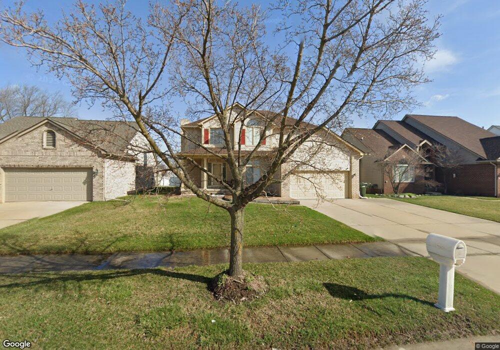
2065 Deveere Dr Sterling Heights, MI 48310
Estimated Value: $418,096 - $490,000
4
Beds
3
Baths
2,257
Sq Ft
$208/Sq Ft
Est. Value
About This Home
This home is located at 2065 Deveere Dr, Sterling Heights, MI 48310 and is currently estimated at $469,274, approximately $207 per square foot. 2065 Deveere Dr is a home located in Macomb County with nearby schools including Angus Elementary School, Grissom Middle School, and Warren Mott High School.
Ownership History
Date
Name
Owned For
Owner Type
Purchase Details
Closed on
Sep 25, 2019
Sold by
Truong Tiflitny Nga and Truong Van Them
Bought by
Nguyen Ca and Luong Nga Thi
Current Estimated Value
Home Financials for this Owner
Home Financials are based on the most recent Mortgage that was taken out on this home.
Original Mortgage
$100,000
Outstanding Balance
$66,498
Interest Rate
3.4%
Mortgage Type
New Conventional
Estimated Equity
$402,776
Purchase Details
Closed on
Sep 21, 2007
Sold by
Le Zanith Long
Bought by
Them Truong Tiffany Nga and Them Van
Purchase Details
Closed on
Feb 6, 1999
Sold by
Mcbroom Brian
Bought by
Long Zanith
Create a Home Valuation Report for This Property
The Home Valuation Report is an in-depth analysis detailing your home's value as well as a comparison with similar homes in the area
Home Values in the Area
Average Home Value in this Area
Purchase History
| Date | Buyer | Sale Price | Title Company |
|---|---|---|---|
| Nguyen Ca | $280,000 | None Available | |
| Them Truong Tiffany Nga | -- | None Available | |
| Long Zanith | $219,000 | -- |
Source: Public Records
Mortgage History
| Date | Status | Borrower | Loan Amount |
|---|---|---|---|
| Open | Nguyen Ca | $100,000 |
Source: Public Records
Tax History Compared to Growth
Tax History
| Year | Tax Paid | Tax Assessment Tax Assessment Total Assessment is a certain percentage of the fair market value that is determined by local assessors to be the total taxable value of land and additions on the property. | Land | Improvement |
|---|---|---|---|---|
| 2025 | $6,813 | $195,100 | $0 | $0 |
| 2024 | $6,572 | $184,500 | $0 | $0 |
| 2023 | $6,239 | $165,800 | $0 | $0 |
| 2022 | $6,050 | $146,900 | $0 | $0 |
| 2021 | $6,253 | $140,900 | $0 | $0 |
| 2020 | $5,944 | $137,100 | $0 | $0 |
| 2019 | $4,464 | $135,000 | $0 | $0 |
| 2018 | $4,626 | $120,200 | $0 | $0 |
| 2017 | $4,464 | $112,500 | $15,400 | $97,100 |
| 2016 | $4,369 | $112,500 | $0 | $0 |
| 2015 | -- | $105,600 | $0 | $0 |
| 2014 | -- | $94,100 | $0 | $0 |
Source: Public Records
Map
Nearby Homes
- 33731 Newport Dr
- 34150 Dequindre Rd
- 2600 Pall Mall Dr
- 2268 Serra Dr
- 2630 Pall Mall Dr
- 2269 Serra Dr
- 2907 Lovington Dr
- 3040 Alden Dr
- 2528 Koper Dr
- 32805 Hawthorne Dr
- 33569 Breckenridge Dr
- 2936 Wisconsin Rd
- 32654 Wareham Ct
- 000 Wisconsin Rd
- 34544 Sandwood Dr
- 3538 Cero Dr
- 32603 Dowland Dr
- 2693 Wisconsin Rd
- 1002 Minnesota Rd
- 32252 Warner Ct
- 2079 Deveere Dr
- 2051 Deveere Dr
- 2037 Deveere Dr
- 2093 Deveere Dr
- 2230 Tarry Dr
- 2218 Tarry Dr
- 2242 Tarry Dr
- 2206 Tarry Dr
- 2023 Deveere Dr
- 2107 Deveere Dr
- 2054 Deveere Dr
- 2068 Deveere Dr
- 2254 Tarry Dr
- 2072 Tarry Dr
- 2040 Deveere Dr
- 2082 Deveere Dr
- 2026 Deveere Dr
- 2009 Deveere Dr
- 2121 Deveere Dr
- 2096 Deveere Dr