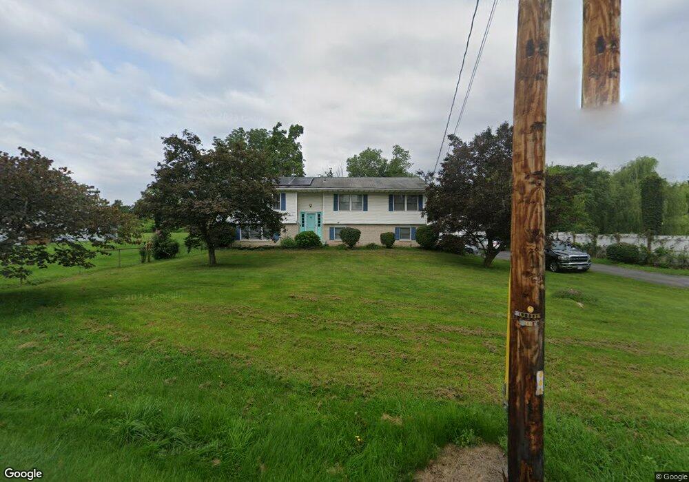
2065 Route 32 Saugerties, NY 12477
Estimated Value: $503,950 - $567,000
4
Beds
2
Baths
2,440
Sq Ft
$220/Sq Ft
Est. Value
About This Home
This home is located at 2065 Route 32, Saugerties, NY 12477 and is currently estimated at $537,988, approximately $220 per square foot. 2065 Route 32 is a home located in Ulster County with nearby schools including Saugerties Senior High School and St Mary Of The Snow School.
Ownership History
Date
Name
Owned For
Owner Type
Purchase Details
Closed on
Dec 17, 2015
Sold by
Lepore Desiree
Bought by
Lee Keniel and Lee Shadia
Current Estimated Value
Purchase Details
Closed on
Jan 22, 2008
Sold by
Kwasnick Mary
Bought by
Pineiro Andrew and Piniero Bridgette S
Home Financials for this Owner
Home Financials are based on the most recent Mortgage that was taken out on this home.
Original Mortgage
$40,000
Interest Rate
7.12%
Mortgage Type
Unknown
Create a Home Valuation Report for This Property
The Home Valuation Report is an in-depth analysis detailing your home's value as well as a comparison with similar homes in the area
Home Values in the Area
Average Home Value in this Area
Purchase History
| Date | Buyer | Sale Price | Title Company |
|---|---|---|---|
| Lee Keniel | $200,000 | -- | |
| Pineiro Andrew | $275,000 | None Available |
Source: Public Records
Mortgage History
| Date | Status | Borrower | Loan Amount |
|---|---|---|---|
| Previous Owner | Pineiro Andrew | $40,000 | |
| Previous Owner | Pineiro Andrew | $180,000 |
Source: Public Records
Tax History Compared to Growth
Tax History
| Year | Tax Paid | Tax Assessment Tax Assessment Total Assessment is a certain percentage of the fair market value that is determined by local assessors to be the total taxable value of land and additions on the property. | Land | Improvement |
|---|---|---|---|---|
| 2024 | $9,319 | $437,000 | $73,500 | $363,500 |
| 2023 | $8,602 | $383,000 | $73,500 | $309,500 |
| 2022 | $8,422 | $327,000 | $73,500 | $253,500 |
| 2021 | $8,422 | $279,000 | $66,500 | $212,500 |
| 2020 | $7,665 | $251,000 | $59,500 | $191,500 |
| 2019 | $6,923 | $251,000 | $59,500 | $191,500 |
| 2018 | $7,418 | $243,500 | $59,500 | $184,000 |
| 2017 | $7,066 | $229,500 | $59,500 | $170,000 |
| 2016 | $7,015 | $229,500 | $59,500 | $170,000 |
| 2015 | -- | $229,500 | $70,000 | $159,500 |
| 2014 | -- | $229,500 | $70,000 | $159,500 |
Source: Public Records
Map
Nearby Homes
- 2084 Route 32
- 135 Hilltop Rd
- 2171 Route 32
- 402 Commons Ln
- 510 Commons Ln
- 2771 U S 9w
- 2294 Route 32
- 0 Tiger Maple Ln
- 45 Sugar Maple Ln Unit 1C
- 2693 Route 9w
- 2679 Route 9w
- 32 Red Maple Rd
- 126 Canterbury Dr
- 123 Barclay Ln
- 30 Glenerie Ln
- TBD Glenerie Ln
- 18 Ridge Rd
- 30 Willow Rd
- 8 Stevens Ct
- 32 Redwood Rd