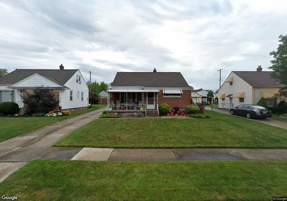
20655 Applegate Rd Maple Heights, OH 44137
Estimated Value: $107,000 - $141,000
2
Beds
1
Bath
852
Sq Ft
$149/Sq Ft
Est. Value
About This Home
This home is located at 20655 Applegate Rd, Maple Heights, OH 44137 and is currently estimated at $126,573, approximately $148 per square foot. 20655 Applegate Rd is a home located in Cuyahoga County with nearby schools including Abraham Lincoln Elementary School, Rockside/ J.F. Kennedy School, and Barack Obama School.
Ownership History
Date
Name
Owned For
Owner Type
Purchase Details
Closed on
May 8, 2003
Sold by
Berry Lenny V
Bought by
Simmons Anthony and Simmons Jacqueline Y
Current Estimated Value
Purchase Details
Closed on
Aug 27, 1996
Sold by
Bonsignore Camila
Bought by
Berry Lenny V
Home Financials for this Owner
Home Financials are based on the most recent Mortgage that was taken out on this home.
Original Mortgage
$70,348
Interest Rate
8.47%
Mortgage Type
FHA
Purchase Details
Closed on
Jan 1, 1975
Bought by
Lacognata Venerina
Create a Home Valuation Report for This Property
The Home Valuation Report is an in-depth analysis detailing your home's value as well as a comparison with similar homes in the area
Home Values in the Area
Average Home Value in this Area
Purchase History
| Date | Buyer | Sale Price | Title Company |
|---|---|---|---|
| Simmons Anthony | $55,000 | Action Title Agency Inc | |
| Berry Lenny V | $70,000 | -- | |
| Lacognata Venerina | -- | -- |
Source: Public Records
Mortgage History
| Date | Status | Borrower | Loan Amount |
|---|---|---|---|
| Previous Owner | Berry Lenny V | $70,348 |
Source: Public Records
Tax History
| Year | Tax Paid | Tax Assessment Tax Assessment Total Assessment is a certain percentage of the fair market value that is determined by local assessors to be the total taxable value of land and additions on the property. | Land | Improvement |
|---|---|---|---|---|
| 2024 | $3,812 | $42,700 | $7,000 | $35,700 |
| 2023 | $2,331 | $21,390 | $4,620 | $16,770 |
| 2022 | $2,323 | $21,390 | $4,620 | $16,770 |
| 2021 | $2,473 | $21,390 | $4,620 | $16,770 |
| 2020 | $2,120 | $16,210 | $3,500 | $12,710 |
| 2019 | $2,106 | $46,300 | $10,000 | $36,300 |
| 2018 | $2,012 | $16,210 | $3,500 | $12,710 |
| 2017 | $2,085 | $15,760 | $3,470 | $12,290 |
| 2016 | $2,015 | $15,760 | $3,470 | $12,290 |
| 2015 | $2,014 | $15,760 | $3,470 | $12,290 |
| 2014 | $2,014 | $17,330 | $3,820 | $13,510 |
Source: Public Records
Map
Nearby Homes
- 339 Grand Blvd
- 19113 Watercrest Ave
- 123 Willard Ave
- 54 Willard Ave
- 419 Center Rd
- 66 Hubbell Way
- 58 Hubbell Way
- 62 Hubbell Way
- 54 Hubbell Way
- 0 Hubbell Cir
- 61 Hubbell Way
- 57 Hubbell Way
- 21202 Gardenview Dr
- 21607 Libby Rd
- 20806 Clare Ave
- 19289 Stafford Ave
- 5424 Fairtree Rd
- 21202 Hillgrove Ave
- 131 Noran Cir
- 5147 Warrensville Center Rd
- 20651 Applegate Rd
- 20659 Applegate Rd
- 20663 Applegate Rd
- 20647 Applegate Rd
- 20662 Bowling Green Rd
- 20658 Bowling Green Rd
- 20666 Bowling Green Rd
- 20654 Bowling Green Rd
- 20667 Applegate Rd
- 20650 Bowling Green Rd
- 20656 Applegate Rd
- 20670 Bowling Green Rd
- 20652 Applegate Rd
- 20660 Applegate Rd
- 20646 Bowling Green Rd
- 20642 Bowling Green Rd
- 20648 Applegate Rd
- 20638 Bowling Green Rd
- 20671 Applegate Rd
- 20664 Applegate Rd
Your Personal Tour Guide
Ask me questions while you tour the home.