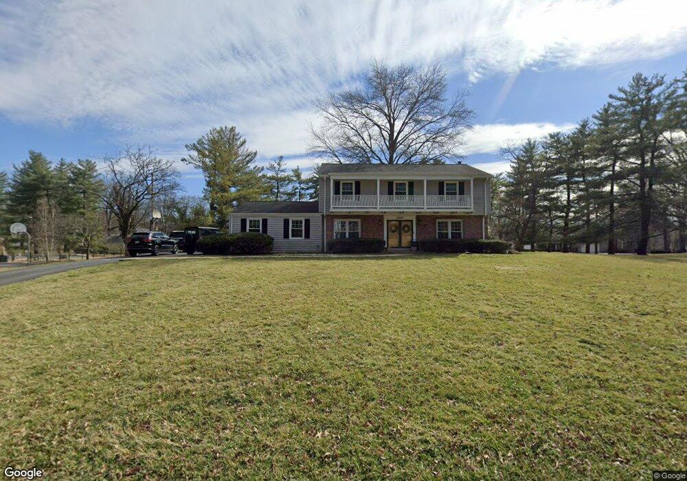
2067 Firethorn Dr Saint Louis, MO 63131
Estimated Value: $814,268 - $912,000
4
Beds
3
Baths
2,570
Sq Ft
$342/Sq Ft
Est. Value
About This Home
This home is located at 2067 Firethorn Dr, Saint Louis, MO 63131 and is currently estimated at $880,067, approximately $342 per square foot. 2067 Firethorn Dr is a home located in St. Louis County with nearby schools including Conway Elementary, Ladue 5th Grade Center, and Ladue Middle School.
Ownership History
Date
Name
Owned For
Owner Type
Purchase Details
Closed on
Jun 15, 2005
Sold by
Diacovo Thomas G and Diacovo Genevieve M Rebuffot
Bought by
Taylor Martin B and Taylor Victoria J
Current Estimated Value
Home Financials for this Owner
Home Financials are based on the most recent Mortgage that was taken out on this home.
Original Mortgage
$300,000
Outstanding Balance
$147,558
Interest Rate
4.87%
Mortgage Type
Fannie Mae Freddie Mac
Estimated Equity
$732,509
Purchase Details
Closed on
Sep 28, 1998
Sold by
Keeline Thomas J and Keeline Marilyn M
Bought by
Diacovo Thomas G and Reboffot Diacovo Genevieve M
Home Financials for this Owner
Home Financials are based on the most recent Mortgage that was taken out on this home.
Original Mortgage
$370,500
Interest Rate
6.37%
Mortgage Type
Assumption
Create a Home Valuation Report for This Property
The Home Valuation Report is an in-depth analysis detailing your home's value as well as a comparison with similar homes in the area
Home Values in the Area
Average Home Value in this Area
Purchase History
| Date | Buyer | Sale Price | Title Company |
|---|---|---|---|
| Taylor Martin B | $560,000 | -- | |
| Diacovo Thomas G | -- | -- |
Source: Public Records
Mortgage History
| Date | Status | Borrower | Loan Amount |
|---|---|---|---|
| Open | Taylor Martin B | $300,000 | |
| Previous Owner | Diacovo Thomas G | $370,500 |
Source: Public Records
Tax History
| Year | Tax Paid | Tax Assessment Tax Assessment Total Assessment is a certain percentage of the fair market value that is determined by local assessors to be the total taxable value of land and additions on the property. | Land | Improvement |
|---|---|---|---|---|
| 2025 | $8,615 | $142,940 | $85,180 | $57,760 |
| 2024 | $8,615 | $125,860 | $69,200 | $56,660 |
| 2023 | $8,606 | $125,860 | $69,200 | $56,660 |
| 2022 | $8,746 | $123,030 | $69,200 | $53,830 |
| 2021 | $8,696 | $123,030 | $69,200 | $53,830 |
| 2020 | $7,424 | $113,710 | $43,850 | $69,860 |
| 2019 | $7,313 | $113,710 | $43,850 | $69,860 |
| 2018 | $6,406 | $91,850 | $30,380 | $61,470 |
| 2017 | $6,381 | $91,850 | $30,380 | $61,470 |
| 2016 | $5,879 | $81,780 | $30,380 | $51,400 |
Source: Public Records
Map
Nearby Homes
- 2046 Willow Leaf Dr
- 1741 Pine Hill Dr
- 11230 Hermitage Hill Place
- 3 Countryside Ln
- 701 Laurel Oak
- 17 Outer Ladue Dr
- 16 Outer Ladue Dr
- 152 Frontenac Forest
- 11 Outer Ladue Dr
- TBB Ballas Ridge Hawthorne II
- TBB
- TBB Ballas Ridge Westchester IV
- TBB Ballas Ridge Roclare II
- TBB
- 2030 N Ballas Rd
- 1534 Woodgate Dr
- 2056 N Ballas Rd
- 2062 N Ballas Rd
- 8 Bridle Ln
- 1319 Kendon Dr
- 2064 Willow Leaf Dr
- 2061 Firethorn Dr
- 2073 Willow Leaf Dr
- 2070 Firethorn Dr
- 2045 Firethorn Dr
- 2058 Willow Leaf Dr
- 2065 Willow Leaf Dr
- 2066 Willow Leaf Dr
- 2039 Firethorn Dr
- 2062 Firethorn Dr
- 2059 Willow Leaf Dr
- 2106 East Dr
- 2056 Firethorn Dr
- 2104 East Dr
- 2110 East Dr
- 2052 Willow Leaf Dr
- 2100 East Dr
- 2112 East Dr
- 2116 East Dr
- 2050 Firethorn Dr
Your Personal Tour Guide
Ask me questions while you tour the home.