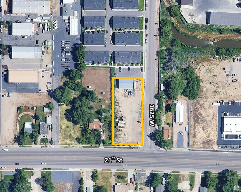


2067 S 1625 W West Haven, UT 84401
Estimated payment $4,144/month
Highlights
- 0.95 Acre Lot
- Corner Lot
- No Heating
- Mountain View
- No HOA
About This Lot
Ideal location for office, retail, & restaurant w/drive-thru potential. Corner lot with excellent visibility. Easy access from NB/SB I-15 and 1900 W.
Property Details
Property Type
- Land
Est. Annual Taxes
- $2,370
Lot Details
- 0.95 Acre Lot
- Lot Dimensions are 0.0x262.3x0.0
- Corner Lot
- Property is zoned Commercial, Industrial, MU
Property Views
- Mountain Views
Schools
- Kanesville Elementary School
Community Details
- No Home Owners Association
Listing and Financial Details
- Assessor Parcel Number 15-680-0003
Map
Home Values in the Area
Average Home Value in this Area
Tax History
| Year | Tax Paid | Tax Assessment Tax Assessment Total Assessment is a certain percentage of the fair market value that is determined by local assessors to be the total taxable value of land and additions on the property. | Land | Improvement |
|---|---|---|---|---|
| 2025 | $2,311 | $229,000 | $147,293 | $81,707 |
| 2024 | $2,180 | $220,000 | $142,541 | $77,459 |
| 2023 | $2,100 | $210,000 | $118,784 | $91,216 |
| 2022 | $1,476 | $151,000 | $104,530 | $46,470 |
| 2021 | $1,374 | $131,000 | $95,028 | $35,972 |
| 2020 | $1,428 | $124,957 | $95,028 | $29,929 |
| 2019 | $0 | $0 | $0 | $0 |
Property History
| Date | Event | Price | List to Sale | Price per Sq Ft |
|---|---|---|---|---|
| 09/10/2025 09/10/25 | For Sale | $750,000 | -- | -- |
Purchase History
| Date | Type | Sale Price | Title Company |
|---|---|---|---|
| Special Warranty Deed | -- | None Available |
Source: UtahRealEstate.com
MLS Number: 2110701
APN: 15-680-0003
Disclaimer: Certain information contained herein is derived from information provided by parties other than Homes.com. All information provided is deemed reliable, but is not guaranteed to be accurate and should be independently verified.
![]() IDX information is provided exclusively for consumers’ personal, non-commercial use, that it may not be used for any purpose other than to identify prospective properties consumers may be interested in purchasing, and that the data is deemed reliable but is not guaranteed accurate by the MLS. Licensor is only providing the MLS Content and not other sources of data provided in the Product.
IDX information is provided exclusively for consumers’ personal, non-commercial use, that it may not be used for any purpose other than to identify prospective properties consumers may be interested in purchasing, and that the data is deemed reliable but is not guaranteed accurate by the MLS. Licensor is only providing the MLS Content and not other sources of data provided in the Product.
Based on information from the Wasatch Front Regional Multiple Listing Service, Inc.. All data, including all measurements and calculations of area, is obtained from various sources and has not been, and will not be, verified by broker or the MLS. All information should be independently reviewed and verified for accuracy. Properties may or may not be listed by the office/agent presenting the information.
- 1161 W Lancelot Ln
- 1137 Excalibur Way
- 2391 W Arthur Way
- 2080 W 1755 Ct S
- 2444 S Andover St Unit 331
- 2176 W 1735 S
- 2448 S Andover St Unit 333
- 2010 S 1100 W
- 2488 S Andover St
- 2455 Gilmour St
- 1694 S Hayfield Dr
- 2072 W 1575 S Unit 136
- 1656 S Prevedel Dr
- 1170 W 17th St
- 1583 S Williams Dr
- 2307 W 2525 S
- 1882 S 2475 W
- 2300 Farmhouse Select Plan at Fairhaven
- 1856 S 2425 W
- 1918 S 2475 W
- 1630 W 2000 S
- 1575 W Riverwalk Dr
- 1110 W Shady Brook Ln
- 2160 S 1200 W
- 2112 W 3300 S
- 264 W Mazey Ln
- 250 W 1680 S
- 407 W 12th St S
- 1685 Wall Ave
- 231 W 12th St
- 434 W 7th St
- 283 Park Blvd
- 2155 Grant Ave
- 426 W 600 S Unit 426 West
- 2860 Wall Ave
- 617 S 375 W
- 314 Park Ave
- 2405 Hinckley Dr
- 310 18th St
- 155 E 900 South St
