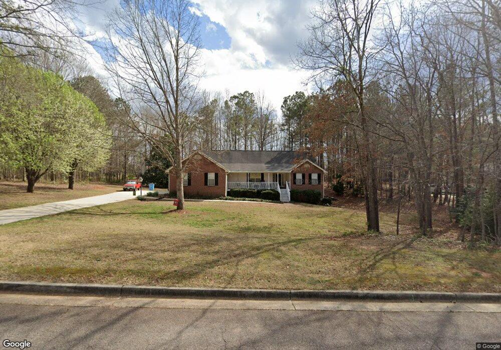
207 Brown Branch Rd Locust Grove, GA 30248
Estimated Value: $305,401 - $351,000
3
Beds
2
Baths
1,909
Sq Ft
$173/Sq Ft
Est. Value
About This Home
This home is located at 207 Brown Branch Rd, Locust Grove, GA 30248 and is currently estimated at $329,850, approximately $172 per square foot. 207 Brown Branch Rd is a home located in Henry County with nearby schools including Unity Grove Elementary School, Locust Grove Middle School, and Locust Grove High School.
Ownership History
Date
Name
Owned For
Owner Type
Purchase Details
Closed on
Nov 25, 1998
Sold by
Strickland Contracting Inc
Bought by
Britt Sr Dewey Wayne and Britt Sr Rebec
Current Estimated Value
Home Financials for this Owner
Home Financials are based on the most recent Mortgage that was taken out on this home.
Original Mortgage
$100,000
Outstanding Balance
$22,173
Interest Rate
6.77%
Mortgage Type
New Conventional
Estimated Equity
$307,677
Create a Home Valuation Report for This Property
The Home Valuation Report is an in-depth analysis detailing your home's value as well as a comparison with similar homes in the area
Home Values in the Area
Average Home Value in this Area
Purchase History
| Date | Buyer | Sale Price | Title Company |
|---|---|---|---|
| Britt Sr Dewey Wayne | $146,900 | -- |
Source: Public Records
Mortgage History
| Date | Status | Borrower | Loan Amount |
|---|---|---|---|
| Open | Britt Sr Dewey Wayne | $100,000 |
Source: Public Records
Tax History Compared to Growth
Tax History
| Year | Tax Paid | Tax Assessment Tax Assessment Total Assessment is a certain percentage of the fair market value that is determined by local assessors to be the total taxable value of land and additions on the property. | Land | Improvement |
|---|---|---|---|---|
| 2025 | $948 | $140,480 | $16,000 | $124,480 |
| 2024 | $948 | $128,680 | $16,000 | $112,680 |
| 2023 | $650 | $127,080 | $14,800 | $112,280 |
| 2022 | $795 | $105,040 | $14,800 | $90,240 |
| 2021 | $795 | $92,000 | $14,800 | $77,200 |
| 2020 | $795 | $84,080 | $13,000 | $71,080 |
| 2019 | $795 | $75,320 | $13,000 | $62,320 |
| 2018 | $795 | $73,080 | $12,000 | $61,080 |
| 2016 | $720 | $61,160 | $10,000 | $51,160 |
| 2015 | $613 | $51,120 | $10,000 | $41,120 |
| 2014 | $705 | $55,800 | $12,000 | $43,800 |
Source: Public Records
Map
Nearby Homes
- 111 Cardell Farms Rd
- 1430 Cleveland Farms Rd
- 1433 Cleveland Farm Rd
- 1430 Cleveland Farm Rd
- 230 Leguin Mill Rd
- 108 Caraway Rd
- Burton III Plan at Bunn Farms
- Jackson III Plan at Bunn Farms
- Hartwell III Plan at Bunn Farms
- Dockery III Plan at Bunn Farms
- 1409 Sodbuster Dr
- 1417 Sodbuster Dr
- 1421 Sodbuster Dr
- 1425 Sodbuster Dr
- 1443 Sodbuster Dr
- 1509 Big Bud Ln
- 1513 Big Bud Ln
- 1680 Leguin Mill Rd
- 1505 Big Bud Ln
- 1500 Big Bud Ln
- 209 Brown Branch Rd
- 205 Brown Branch Rd
- 309 Farm View Ct
- 313 Farm View Ct
- 206 Brown Branch Rd
- 208 Brown Branch Rd
- 211 Brown Branch Rd
- 305 Farm View Ct
- 204 Brown Branch Rd
- 102 Cardell Farms Rd
- 210 Brown Branch Rd
- 104 Cardell Farms Rd
- 138 Cardell Farms Rd
- 317 Farm View Ct
- 202 Brown Branch Rd
- 301 Farm View Ct
- 306 Farm View Ct
- 212 Brown Branch Rd
- 0 Farm View Ct
- 156 Cardell Dr