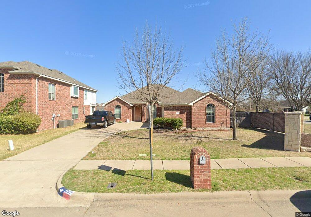
207 Buttercup Way Red Oak, TX 75154
Estimated Value: $321,340 - $338,000
3
Beds
2
Baths
1,984
Sq Ft
$166/Sq Ft
Est. Value
About This Home
This home is located at 207 Buttercup Way, Red Oak, TX 75154 and is currently estimated at $329,670, approximately $166 per square foot. 207 Buttercup Way is a home located in Ellis County with nearby schools including Red Oak Elementary School, Red Oak Middle School, and Red Oak High School.
Ownership History
Date
Name
Owned For
Owner Type
Purchase Details
Closed on
Jul 8, 2019
Sold by
Mcgill Kendall
Bought by
Bernal Carrie
Current Estimated Value
Home Financials for this Owner
Home Financials are based on the most recent Mortgage that was taken out on this home.
Original Mortgage
$214,541
Outstanding Balance
$187,607
Interest Rate
3.73%
Mortgage Type
FHA
Estimated Equity
$142,063
Purchase Details
Closed on
Apr 17, 2015
Sold by
Ewing Michael C and Ewing Allison
Bought by
Mcgill Kendall
Home Financials for this Owner
Home Financials are based on the most recent Mortgage that was taken out on this home.
Original Mortgage
$173,469
Interest Rate
3.89%
Mortgage Type
New Conventional
Purchase Details
Closed on
May 23, 2011
Sold by
Sumeer Homes Inc
Bought by
Ewing Michael C and Ewing Allison
Home Financials for this Owner
Home Financials are based on the most recent Mortgage that was taken out on this home.
Original Mortgage
$148,005
Interest Rate
4.95%
Mortgage Type
New Conventional
Create a Home Valuation Report for This Property
The Home Valuation Report is an in-depth analysis detailing your home's value as well as a comparison with similar homes in the area
Home Values in the Area
Average Home Value in this Area
Purchase History
| Date | Buyer | Sale Price | Title Company |
|---|---|---|---|
| Bernal Carrie | -- | None Available | |
| Mcgill Kendall | -- | None Available | |
| Ewing Michael C | -- | None Available |
Source: Public Records
Mortgage History
| Date | Status | Borrower | Loan Amount |
|---|---|---|---|
| Open | Bernal Carrie | $214,541 | |
| Previous Owner | Mcgill Kendall | $173,469 | |
| Previous Owner | Ewing Michael C | $148,005 |
Source: Public Records
Tax History Compared to Growth
Tax History
| Year | Tax Paid | Tax Assessment Tax Assessment Total Assessment is a certain percentage of the fair market value that is determined by local assessors to be the total taxable value of land and additions on the property. | Land | Improvement |
|---|---|---|---|---|
| 2025 | $6,933 | $317,994 | $60,500 | $257,494 |
| 2024 | $6,933 | $334,252 | $60,500 | $273,752 |
| 2023 | $6,933 | $367,853 | $60,500 | $307,353 |
| 2022 | $6,567 | $287,494 | $55,000 | $232,494 |
| 2021 | $5,747 | $238,160 | $33,000 | $205,160 |
| 2020 | $5,678 | $226,900 | $30,000 | $196,900 |
| 2019 | $5,804 | $227,900 | $0 | $0 |
| 2018 | $4,871 | $201,680 | $25,000 | $176,680 |
| 2017 | $4,905 | $188,480 | $25,000 | $163,480 |
| 2016 | $4,812 | $184,880 | $25,000 | $159,880 |
| 2015 | $3,788 | $157,780 | $23,000 | $134,780 |
| 2014 | $3,788 | $155,240 | $0 | $0 |
Source: Public Records
Map
Nearby Homes
- 312 N Lowrance Rd
- 111 Evening Star Cir
- 122 Yvonne St
- 120 Autumn Trail
- 328 Meadow Ln
- 203 N Main St
- 325 N State Highway 342
- 206 Methodist St
- 127 Hollie Dr
- 233 Garden Valley Ln
- 108 Forest Park Ln
- 317 Quail Run Rd
- 103 N Summit St
- 332 Bob White Dr
- 326 Fox Hollow Dr
- 110 N Hillside St
- 104 Harvest Hill Ln
- 560 Glenn Ln
- 105 Basswood Dr
- 213 Brian Way
- 205 Buttercup Way
- 125 Evening Star Cir
- 203 Buttercup Way
- 204 Buttercup Way
- 127 Evening Star Cir
- 202 Buttercup Way
- 123 Evening Star Cir
- 201 Buttercup Way
- 314 N Lowrance Rd
- 200 Buttercup Way
- 308 N Lowrance Rd
- 126 Evening Star Cir
- 309 Briar Cove Cir
- 121 Evening Star Cir
- 307 Briar Cove Cir
- 400 N Lowrance Rd
- 304 N Lowrance Rd
- 124 Evening Star Cir
- 305 Briar Cove Cir
- 207 Morningstar Ln