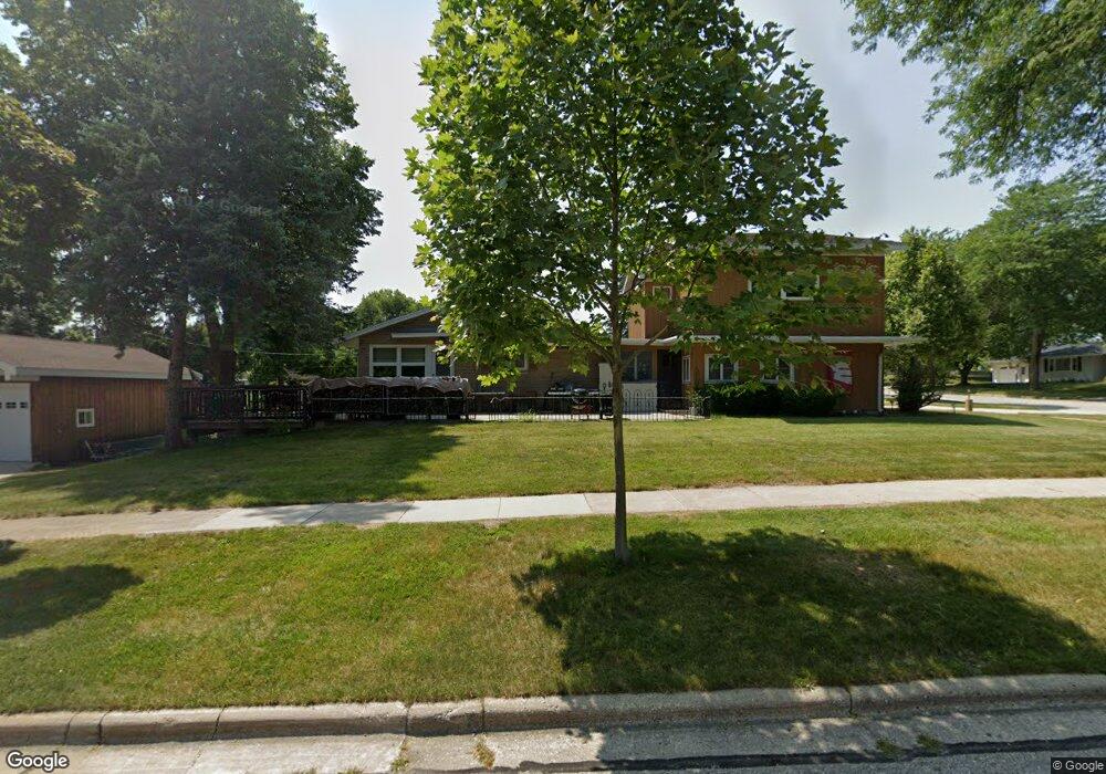
207 Butternut St West Bend, WI 53095
Estimated Value: $368,000 - $542,000
4
Beds
3
Baths
3,696
Sq Ft
$127/Sq Ft
Est. Value
About This Home
This home is located at 207 Butternut St, West Bend, WI 53095 and is currently estimated at $467,831, approximately $126 per square foot. 207 Butternut St is a home located in Washington County with nearby schools including Decorah Elementary School, Badger Middle School, and East High School.
Ownership History
Date
Name
Owned For
Owner Type
Purchase Details
Closed on
Jul 27, 2015
Sold by
Dunford Bruce W
Bought by
Quigley Lance
Current Estimated Value
Purchase Details
Closed on
Feb 20, 2007
Sold by
Suckow Lucille J
Bought by
Dunford Bruce W and Dunford Deborah L
Home Financials for this Owner
Home Financials are based on the most recent Mortgage that was taken out on this home.
Original Mortgage
$197,000
Interest Rate
6.23%
Mortgage Type
New Conventional
Create a Home Valuation Report for This Property
The Home Valuation Report is an in-depth analysis detailing your home's value as well as a comparison with similar homes in the area
Home Values in the Area
Average Home Value in this Area
Purchase History
| Date | Buyer | Sale Price | Title Company |
|---|---|---|---|
| Quigley Lance | $210,000 | -- | |
| Dunford Bruce W | $204,400 | Priority Title Corporation |
Source: Public Records
Mortgage History
| Date | Status | Borrower | Loan Amount |
|---|---|---|---|
| Previous Owner | Dunford Bruce W | $197,000 |
Source: Public Records
Tax History Compared to Growth
Tax History
| Year | Tax Paid | Tax Assessment Tax Assessment Total Assessment is a certain percentage of the fair market value that is determined by local assessors to be the total taxable value of land and additions on the property. | Land | Improvement |
|---|---|---|---|---|
| 2024 | $5,912 | $451,000 | $58,000 | $393,000 |
| 2023 | $5,267 | $298,300 | $59,500 | $238,800 |
| 2022 | $5,279 | $298,300 | $59,500 | $238,800 |
| 2021 | $5,425 | $298,300 | $59,500 | $238,800 |
| 2020 | $5,318 | $298,300 | $59,500 | $238,800 |
| 2019 | $5,151 | $298,300 | $59,500 | $238,800 |
| 2018 | $4,052 | $244,000 | $59,500 | $184,500 |
| 2017 | $4,217 | $227,200 | $59,500 | $167,700 |
| 2016 | $4,021 | $215,700 | $59,500 | $156,200 |
| 2015 | $4,101 | $215,700 | $59,500 | $156,200 |
| 2014 | $4,101 | $215,700 | $59,500 | $156,200 |
| 2013 | $4,432 | $215,700 | $59,500 | $156,200 |
Source: Public Records
Map
Nearby Homes
- 2600 S Main St
- 1040 Lincoln Dr W
- 1317 S 7th Ave
- 1071 Anchor Ave
- 1063 Anchor Ave
- 1125 Anchor Ave
- 1117 Anchor Ave
- 638 Vine St
- 1301 Goldcrest Ct
- 1403 Carriage Dr
- 915 Schloemer Dr
- 1275 Shadowood Cir Unit 110
- 1014 Cottonwood Ct
- 1130 S River Rd
- 1444 Hidden Waters Cir
- 2040 Paradise Hills Ct
- 787 Sheridan Dr
- 2490 S River Rd
- 546 S Main St
- 1707 Eden Dr
- 204 Butternut St
- 1505 Sylvan Way
- 210 Butternut St
- 1522 Sylvan Way
- 210 Maplewynde Rd
- 217 Butternut St
- 1513 Sylvan Way
- 1519 Sylvan Way
- 216 Maplewynde Rd
- 1401 Sylvan Way
- 227 Butternut St
- 1527 Sylvan Way
- 224 Maplewynde Rd
- 1354 Sylvan Way
- 185 Laurel Dr S
- 233 Butternut St
- 1606 Sylvan Way
- 190 Laurel Dr S
- 1520 Woodridge Rd
- 1510 Woodridge Rd