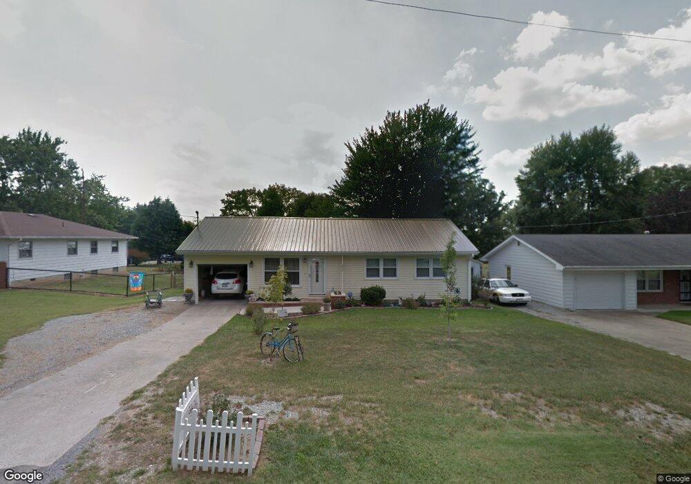
207 E Powell Ave Mc Leansboro, IL 62859
Estimated Value: $51,000 - $95,000
Studio
--
Bath
--
Sq Ft
13,504
Sq Ft Lot
About This Home
This home is located at 207 E Powell Ave, Mc Leansboro, IL 62859 and is currently estimated at $78,921. 207 E Powell Ave is a home with nearby schools including Hamilton County Junior/Senior High School.
Ownership History
Date
Name
Owned For
Owner Type
Purchase Details
Closed on
Jan 3, 2018
Sold by
Owen Mary Ann
Bought by
Daniel George M and Daniel Carolsue
Current Estimated Value
Purchase Details
Closed on
Sep 27, 2011
Sold by
Pryer Audrey N and Pryer Charles L
Bought by
Owen David E and Owen Mary Ann
Home Financials for this Owner
Home Financials are based on the most recent Mortgage that was taken out on this home.
Original Mortgage
$40,000
Interest Rate
4.14%
Mortgage Type
Purchase Money Mortgage
Purchase Details
Closed on
Apr 30, 2007
Sold by
Oldham Donald L and Oldham Marjorie L
Bought by
Owen David E and Owen Mary Ann
Create a Home Valuation Report for This Property
The Home Valuation Report is an in-depth analysis detailing your home's value as well as a comparison with similar homes in the area
Home Values in the Area
Average Home Value in this Area
Purchase History
| Date | Buyer | Sale Price | Title Company |
|---|---|---|---|
| Daniel George M | $75,000 | -- | |
| Owen David E | $40,000 | None Available | |
| Owen David E | $6,500 | None Available |
Source: Public Records
Mortgage History
| Date | Status | Borrower | Loan Amount |
|---|---|---|---|
| Previous Owner | Owen David E | $40,000 |
Source: Public Records
Tax History
| Year | Tax Paid | Tax Assessment Tax Assessment Total Assessment is a certain percentage of the fair market value that is determined by local assessors to be the total taxable value of land and additions on the property. | Land | Improvement |
|---|---|---|---|---|
| 2024 | $266 | $24,974 | $2,318 | $22,656 |
| 2023 | $275 | $25,747 | $2,390 | $23,357 |
| 2022 | $288 | $20,756 | $2,240 | $18,516 |
| 2021 | $745 | $19,960 | $2,154 | $17,806 |
| 2020 | $295 | $18,793 | $2,028 | $16,765 |
| 2019 | $295 | $18,793 | $2,028 | $16,765 |
| 2018 | $298 | $3,092 | $2,028 | $1,064 |
| 2017 | $297 | $3,092 | $2,028 | $1,064 |
| 2015 | $292 | $3,092 | $2,041 | $1,051 |
| 2014 | $289 | $16,488 | $1,969 | $14,519 |
| 2013 | -- | $16,488 | $1,969 | $14,519 |
| 2012 | -- | $14,092 | $1,683 | $12,409 |
Source: Public Records
Map
Nearby Homes
- 000 E Maple St
- 107 W Carpenter St
- 201 N Washington St
- 108 N Walnut St
- 502 Old Brickyard Rd
- 105 N Epperson Dr
- 000 W Main St
- 312 E Randolph St
- 602 W Cherry St
- 511 S Washington St
- 909 S Jackson St
- 1100 John Stelle Rd
- 54 Meadow Hills Ln
- 000 Memory Ln
- 000 Eric Ln
- 000 E County Rd Unit 950
- 9540 State Route 142
- 6722 County Road 875 N
- 13858 Cr 1700 E
- 0000 Campbell's Corner Rd
- 205 E Powell Ave
- 209 E Powell Ave
- 206 E Powell Ave
- 208 E Powell Ave
- 204 E Powell Ave
- 210 E Powell Ave
- 210 E Powell Ave
- 508 N Locust St
- 511 N Locust St
- 202 E Powell Ave
- 509 N Locust St
- 203 Powell Ave
- 201 Powell Ave
- 200 Powell Ave
- 607 N Locust St
- 205 E Blackburn Ave
- 609 N Jackson St
- 107 E Powell Ave
- 506 N Jackson St
- 606 N Jackson St
Your Personal Tour Guide
Ask me questions while you tour the home.