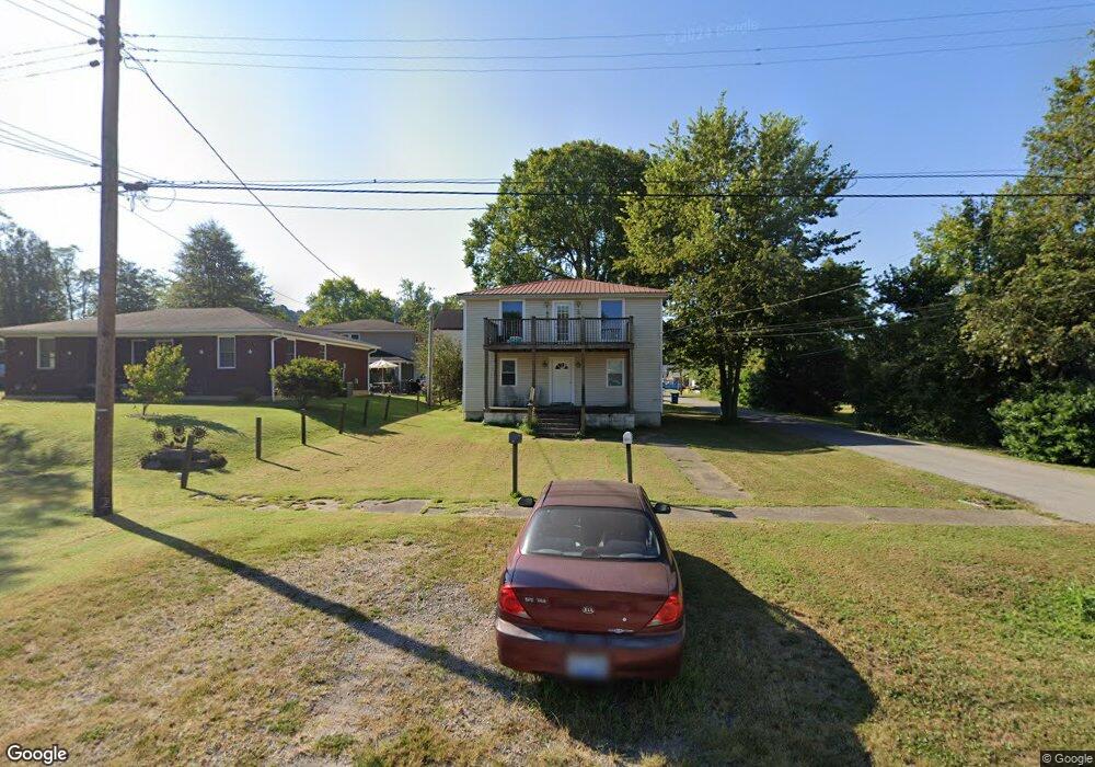
207 Elm St West Point, KY 40177
Estimated Value: $110,706 - $175,000
4
Beds
2
Baths
1,790
Sq Ft
$77/Sq Ft
Est. Value
About This Home
This home is located at 207 Elm St, West Point, KY 40177 and is currently estimated at $137,427, approximately $76 per square foot. 207 Elm St is a home located in Hardin County with nearby schools including West Point Elementary School, Nichols Elementary School, and Bullitt Lick Middle School.
Ownership History
Date
Name
Owned For
Owner Type
Purchase Details
Closed on
Jun 30, 2023
Sold by
Ciresi Richard A and Ciresi Bonnie K
Bought by
Carter Robert A
Current Estimated Value
Purchase Details
Closed on
Jun 9, 2011
Sold by
Armijo Christopher L and Priest Brandon
Bought by
Ciresi Richard A and Ciresi Bonnie K
Create a Home Valuation Report for This Property
The Home Valuation Report is an in-depth analysis detailing your home's value as well as a comparison with similar homes in the area
Purchase History
| Date | Buyer | Sale Price | Title Company |
|---|---|---|---|
| Carter Robert A | $10,000 | None Listed On Document | |
| Ciresi Richard A | $58,200 | None Available |
Source: Public Records
Tax History
| Year | Tax Paid | Tax Assessment Tax Assessment Total Assessment is a certain percentage of the fair market value that is determined by local assessors to be the total taxable value of land and additions on the property. | Land | Improvement |
|---|---|---|---|---|
| 2025 | $750 | $58,200 | $4,100 | $54,100 |
| 2024 | $757 | $58,200 | $4,100 | $54,100 |
| 2023 | $740 | $58,200 | $4,100 | $54,100 |
| 2022 | $797 | $58,200 | $4,100 | $54,100 |
| 2021 | $771 | $58,200 | $4,100 | $54,100 |
| 2020 | $471 | $58,200 | $4,100 | $54,100 |
| 2019 | $0 | $58,200 | $0 | $0 |
| 2018 | $1,023 | $58,200 | $0 | $0 |
| 2017 | $1,021 | $58,200 | $0 | $0 |
| 2016 | $0 | $58,200 | $0 | $0 |
| 2015 | $1,005 | $58,200 | $0 | $0 |
| 2012 | -- | $58,200 | $0 | $0 |
Source: Public Records
Map
Nearby Homes
- 409 Elm St
- 14555 Old Highway 111 SE
- 11330 Lambs Ridge Rd SE
- 309 Churchview Rd
- 0 Rosewood Rd SE
- 10055 Old Highway 111 SE
- 7013 Shipley Ln
- 6918 Bowen Ave
- 14019 Darwin Blvd
- 7213 Rainbow Dr
- 7303 Rainbow Dr
- 7112 Dunkirk Ln
- 7414 Dunkirk Ln
- 7114 Nathan Hale Way
- 7307 Nathan Hale Way
- 7319 Betsy Ross Dr
- 7209 Watson Ln
- 7408 Wimstock Ave
- 13405 Lidcomb Ave
- 406 Snyder Way
Your Personal Tour Guide
Ask me questions while you tour the home.