
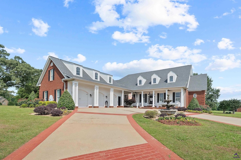
207 Josiah Ct Macon, GA 31220
Estimated payment $4,029/month
Total Views
50,935
5
Beds
5
Baths
4,773
Sq Ft
$142
Price per Sq Ft
Highlights
- Engineered Wood Flooring
- 3 Fireplaces
- Sun or Florida Room
- Main Floor Primary Bedroom
- Bonus Room
- Granite Countertops
About This Home
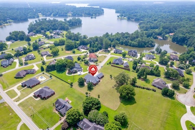
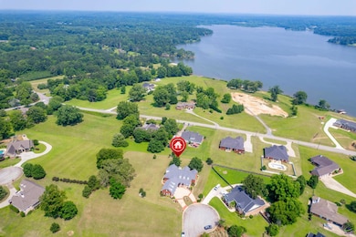
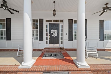
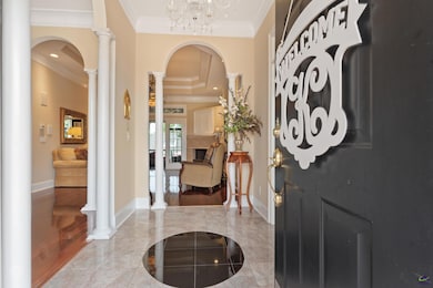
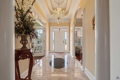
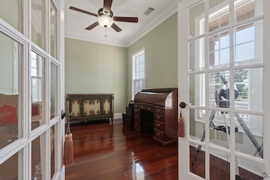
Beautifully designed 4,773 sq ft custom home on a serene 1.2-acre lot with lake access in Browns Cove, this spacious retreat offers a perfect blend of elegance, comfort, and functionality with views of Lake Tobesofkee. Featuring 5 bedrooms and 5 full bathrooms, this home was thoughtfully designed for both family living and entertaining. The large open floor plan is accentuated by beautiful crown molding, high ceilings, and rich natural light throughout. At the heart of the home is a gourmet eat-in kitchen complete with a cozy sitting area and fireplace, upscale stainless steel appliances, a wet bar, and ample prep and storage space plus an oversized island — perfect for hosting gatherings or enjoying quiet mornings. The master suite provides a private retreat, complete with an ensuite bathroom, sitting area with fireplace for ultimate relaxation. Upstairs, a generous playroom provides flexible space for recreation or relaxation. Over the garage, you'll find a private theater room with its own mini bar and full bathroom, offering the ultimate entertainment experience. Schedule your private showing today and make this Browns Cove gem your forever home.
Home Details
Home Type
- Single Family
Est. Annual Taxes
- $5,203
Year Built
- Built in 2003
Lot Details
- 1.2 Acre Lot
- Sprinkler System
HOA Fees
- $15 Monthly HOA Fees
Parking
- 3 Car Attached Garage
Home Design
- Brick Exterior Construction
- Cement Siding
Interior Spaces
- 4,773 Sq Ft Home
- 1.5-Story Property
- Central Vacuum
- Crown Molding
- 3 Fireplaces
- Double Pane Windows
- Formal Dining Room
- Home Office
- Bonus Room
- Game Room
- Sun or Florida Room
- Screened Porch
- Crawl Space
- Storage In Attic
Kitchen
- Eat-In Kitchen
- Breakfast Bar
- Built-In Oven
- Cooktop
- Microwave
- Dishwasher
- Kitchen Island
- Granite Countertops
- Compactor
Flooring
- Engineered Wood
- Carpet
- Tile
Bedrooms and Bathrooms
- 5 Bedrooms
- Primary Bedroom on Main
- Split Bedroom Floorplan
- 5 Full Bathrooms
- Garden Bath
Home Security
- Home Security System
- Storm Windows
Schools
- Bibb-Skyview Elementary School
- Bibb-Rutland Middle School
- Bibb- Rutland High School
Utilities
- Multiple cooling system units
- Central Heating and Cooling System
- Underground Utilities
Listing and Financial Details
- Tax Lot 37
- Assessor Parcel Number F008-0196
Map
Create a Home Valuation Report for This Property
The Home Valuation Report is an in-depth analysis detailing your home's value as well as a comparison with similar homes in the area
Home Values in the Area
Average Home Value in this Area
Tax History
| Year | Tax Paid | Tax Assessment Tax Assessment Total Assessment is a certain percentage of the fair market value that is determined by local assessors to be the total taxable value of land and additions on the property. | Land | Improvement |
|---|---|---|---|---|
| 2025 | $5,203 | $218,708 | $13,000 | $205,708 |
| 2024 | $5,377 | $218,708 | $13,000 | $205,708 |
| 2023 | $4,361 | $196,712 | $13,000 | $183,712 |
| 2022 | $5,878 | $176,774 | $24,000 | $152,774 |
| 2021 | $5,694 | $156,847 | $24,000 | $132,847 |
| 2020 | $5,818 | $156,847 | $24,000 | $132,847 |
| 2019 | $6,021 | $160,823 | $24,000 | $136,823 |
| 2018 | $9,402 | $160,823 | $24,000 | $136,823 |
| 2017 | $6,025 | $160,823 | $24,000 | $136,823 |
| 2016 | $5,564 | $160,823 | $24,000 | $136,823 |
| 2015 | $7,876 | $160,823 | $24,000 | $136,823 |
| 2014 | $9,674 | $197,244 | $27,600 | $169,644 |
Source: Public Records
Property History
| Date | Event | Price | List to Sale | Price per Sq Ft |
|---|---|---|---|---|
| 09/29/2025 09/29/25 | Price Changed | $680,000 | -1.4% | $142 / Sq Ft |
| 07/23/2025 07/23/25 | Price Changed | $690,000 | -7.4% | $145 / Sq Ft |
| 06/09/2025 06/09/25 | For Sale | $745,000 | -- | $156 / Sq Ft |
Source: Central Georgia MLS
Purchase History
| Date | Type | Sale Price | Title Company |
|---|---|---|---|
| Warranty Deed | $425,000 | None Available | |
| Warranty Deed | $36,000 | -- |
Source: Public Records
Mortgage History
| Date | Status | Loan Amount | Loan Type |
|---|---|---|---|
| Open | $340,000 | New Conventional |
Source: Public Records
About the Listing Agent
For more than two decades, Nancy King has been dedicated to helping families find their dream homes in Middle Georgia. As an Associate Broker with Coldwell Banker Access Realty, a Certified Global Luxury Specialist, and a Lifetime Member of the Circle of Excellence, she brings unmatched expertise and professionalism to every transaction. Recognized for her negotiation skills since 2013 and honored by the Coldwell Banker International Diamond Society, Nancy is proud to be among the area’s
Nancy's Other Listings
-
$440,000
- 4 Beds
- 4 Baths
- 3,472 Sq Ft
- 139 River Knoll
- Macon, GA
Jones County - River North Gated Community Nestled on 3.52 private, riverfront acres in the highly desirable River North community, this spacious 3,472 sq. ft. brick home with a 2 car garage offers 4 bedrooms, 2 full bathrooms, and 2 half bathrooms. Step inside to find real hardwood floors throughout, a welcoming living room with a fireplace and wet bar, and a beautiful screened-in porch with
Nancy King Coldwell Banker Access Realty
-
$325,100 Sold May 23, 2025
- 4 Beds
- 2.5 Baths
- 2,419 Sq Ft
- 6579 Dana Dr
- MacOn, GA
Welcome to 6579 Dana Dr, Macon, GA 31220-a home designed to impress, equipped for modern living and outdoor fun! This custom-built 4-bedroom, 2.5-bathroom two story residence offers 2,419 square feet of elegant living space. The custom layout features a grand living room, luxurious first floor primary suite, and three bedrooms/full bathroom on the second floor. This is complemented by an
Nancy King Coldwell Banker Access Realty
-
$425,000 Sold Nov 03, 2025
- 3 Beds
- 2.5 Baths
- 3,183 Sq Ft
- 218 Gates Rd
- Lizella, GA
**Contingent** Custom-Built Lake Tobesofkee Home with Designer Upgrades! Move-in ready and meticulously maintained by its original owner, this stunning custom-built home offers lake access and refined living just steps from Lake Tobesofkee. With hardwood floors throughout both levels, this 3-bedroom, 2-bathroom residence includes an office, two spacious living areas, a cozy family room, and a
Nancy King Coldwell Banker Access Realty, Macon
-
$655,000 Sold Dec 19, 2024
- 5 Beds
- 6 Baths
- 4,739 Sq Ft
- 141 Waterford Place
- Macon, GA
Welcome to Your Dream Home in North Macon Nestled in a quiet cul-de-sac, this luxury residence offers a perfect blend of elegance and comfort. Enjoy year-round relaxation in your private, heated saltwater pool with views from all rooms. This home features spacious living areas which are designed for large families, an expansive great room with a cozy fireplace, perfect for gatherings and
Nancy King Coldwell Banker Access Realty
-
$25,000 Sold Apr 23, 2025
- Land
- 0.76 Acre Lot
- 128 Oakview Club Dr
- Macon, GA
Corner lot with .76 acres in Oakview, subdivision with golf and clubhouse. Great location and priced to sell.
Nancy King Coldwell Banker Access Realty
Source: Central Georgia MLS
MLS Number: 253797
APN: F008-0196
Disclaimer: Certain information contained herein is derived from information provided by parties other than Homes.com. All information provided is deemed reliable, but is not guaranteed to be accurate and should be independently verified.
![]() IDX information is provided exclusively for personal, non-commercial use, and may not be used for any purpose other than to identify prospective properties consumers may be interested in purchasing. Information is deemed reliable but not guaranteed.
IDX information is provided exclusively for personal, non-commercial use, and may not be used for any purpose other than to identify prospective properties consumers may be interested in purchasing. Information is deemed reliable but not guaranteed.
Nearby Homes
- 1149 Runnymede Ln
- 6300 Moseley Dixon Rd
- 1356 Happy Trail
- 437 Kildare Way
- 6229 Thomaston Rd
- 181 Kinsale Dr
- 301 Barrington Hall Dr
- 5744 Thomaston Rd
- 6001 Thomaston Rd
- 5891 Thomaston Rd
- 328 Shady Ln
- 6435 Zebulon Rd
- 101 Yearwood Dr
- 600 Lamar Rd
- 399 Plantation Way
- 5801 Zebulon Rd
- 19 Spell Ln
- 4274 W Oak Dr
- 4786 High Oak Dr
- 4564 Brookhaven Rd