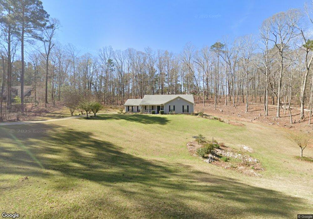
207 Linda Ln Lagrange, GA 30240
Estimated Value: $220,000 - $280,000
3
Beds
3
Baths
1,894
Sq Ft
$139/Sq Ft
Est. Value
About This Home
This home is located at 207 Linda Ln, Lagrange, GA 30240 and is currently estimated at $263,188, approximately $138 per square foot. 207 Linda Ln is a home located in Troup County with nearby schools including Ethel W. Kight Elementary School, Hollis Hand Elementary School, and Franklin Forest Elementary School.
Ownership History
Date
Name
Owned For
Owner Type
Purchase Details
Closed on
May 26, 2006
Sold by
Beard David
Bought by
Malebranche Ernest J and Malebranche Sheila
Current Estimated Value
Purchase Details
Closed on
Nov 13, 2002
Sold by
Bank One National Assoc
Bought by
Allison David and Allison Beard
Purchase Details
Closed on
Jul 2, 2002
Sold by
Linda Chris and Linda Bryan
Bought by
Bank One National Assoc
Purchase Details
Closed on
Apr 23, 1998
Sold by
Hales Mary
Bought by
Linda Chris and Linda Bryan
Purchase Details
Closed on
Jan 1, 1987
Sold by
Larry M Hales
Bought by
Hales Mary
Create a Home Valuation Report for This Property
The Home Valuation Report is an in-depth analysis detailing your home's value as well as a comparison with similar homes in the area
Purchase History
| Date | Buyer | Sale Price | Title Company |
|---|---|---|---|
| Malebranche Ernest J | $145,000 | -- | |
| Allison David | $115,000 | -- | |
| Bank One National Assoc | $106,300 | -- | |
| Linda Chris | $6,000 | -- | |
| Hales Mary | -- | -- |
Source: Public Records
Tax History
| Year | Tax Paid | Tax Assessment Tax Assessment Total Assessment is a certain percentage of the fair market value that is determined by local assessors to be the total taxable value of land and additions on the property. | Land | Improvement |
|---|---|---|---|---|
| 2025 | $1,730 | $95,440 | $18,000 | $77,440 |
| 2024 | $1,584 | $87,120 | $18,000 | $69,120 |
| 2023 | $1,465 | $82,760 | $14,000 | $68,760 |
| 2022 | $1,292 | $74,920 | $10,000 | $64,920 |
| 2021 | $1,546 | $53,240 | $8,000 | $45,240 |
| 2020 | $1,546 | $53,240 | $8,000 | $45,240 |
| 2019 | $1,522 | $52,440 | $6,000 | $46,440 |
| 2018 | $1,522 | $52,440 | $6,000 | $46,440 |
| 2017 | $1,381 | $47,760 | $4,800 | $42,960 |
| 2016 | $1,361 | $47,121 | $4,800 | $42,321 |
| 2015 | $1,364 | $47,121 | $4,800 | $42,321 |
| 2014 | $1,299 | $44,893 | $4,800 | $40,093 |
| 2013 | -- | $47,461 | $4,800 | $42,661 |
Source: Public Records
Map
Nearby Homes
- 213 Linda Ln
- 851 Vernon Ferry Rd
- 103 Dogwood Ct
- 104 Dogwood Point
- 110 Thomas Dr
- 129 Angela East Dr
- 4.51 ACRES Whatley Rd N
- 0 Deming St Unit 10550189
- 134 N Lake Dr
- 1017 Riverside Dr
- 4004 White Oak Ln
- 40 River Point Dr
- 16 River Point Dr
- 6 Hastings Ct
- 474 Newton Rd
- 98 Hearn Rd
- 113 Colonial Ct
- 101 Ivy Springs Dr
- 311 Cumberland Dr
- 300 Cumberland Dr
Your Personal Tour Guide
Ask me questions while you tour the home.