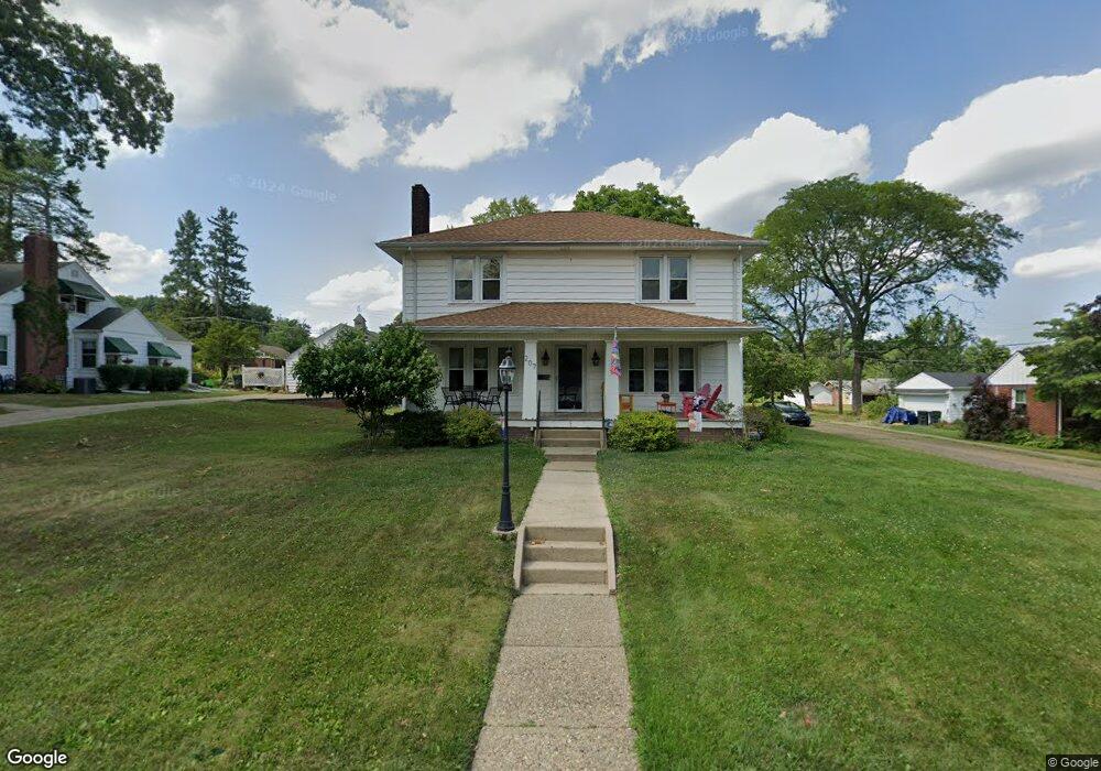
207 Linwood Dr Alliance, OH 44601
Estimated Value: $221,131 - $262,000
3
Beds
2
Baths
1,988
Sq Ft
$123/Sq Ft
Est. Value
About This Home
This home is located at 207 Linwood Dr, Alliance, OH 44601 and is currently estimated at $244,783, approximately $123 per square foot. 207 Linwood Dr is a home located in Stark County with nearby schools including Alliance Elementary School at Rockhill, Alliance Intermediate School at Northside, and Alliance Middle School.
Ownership History
Date
Name
Owned For
Owner Type
Purchase Details
Closed on
Feb 14, 2012
Sold by
Vega Peter V
Bought by
Vega Barbara
Current Estimated Value
Purchase Details
Closed on
Apr 13, 1995
Sold by
Rosenberger Rollin D
Bought by
Vega Peter V and Vega Barbara
Create a Home Valuation Report for This Property
The Home Valuation Report is an in-depth analysis detailing your home's value as well as a comparison with similar homes in the area
Home Values in the Area
Average Home Value in this Area
Purchase History
| Date | Buyer | Sale Price | Title Company |
|---|---|---|---|
| Vega Barbara | -- | Attorney | |
| Vega Peter V | $86,500 | -- |
Source: Public Records
Tax History Compared to Growth
Tax History
| Year | Tax Paid | Tax Assessment Tax Assessment Total Assessment is a certain percentage of the fair market value that is determined by local assessors to be the total taxable value of land and additions on the property. | Land | Improvement |
|---|---|---|---|---|
| 2025 | -- | $69,620 | $12,880 | $56,740 |
| 2024 | -- | $69,620 | $12,880 | $56,740 |
| 2023 | $1,715 | $42,670 | $11,060 | $31,610 |
| 2022 | $1,726 | $42,670 | $11,060 | $31,610 |
| 2021 | $1,728 | $42,670 | $11,060 | $31,610 |
| 2020 | $1,609 | $37,110 | $9,630 | $27,480 |
| 2019 | $1,586 | $37,110 | $9,630 | $27,480 |
| 2018 | $1,593 | $37,110 | $9,630 | $27,480 |
| 2017 | $1,462 | $33,500 | $8,050 | $25,450 |
| 2016 | $1,474 | $33,500 | $8,050 | $25,450 |
| 2015 | $1,487 | $33,500 | $8,050 | $25,450 |
| 2014 | $1,654 | $35,470 | $8,510 | $26,960 |
| 2013 | $825 | $35,470 | $8,510 | $26,960 |
Source: Public Records
Map
Nearby Homes
- 2705 Shunk Ave
- 3101 Ridgehill Ave
- 2839 S Rockhill Ave
- 236 E Milton St
- 2460 S Arch Ave
- 277 W Carol St
- 555 E Milton St
- 2408 S Linden Ave
- 1059 Oakwood Dr
- 2376 S Seneca Ave
- 2218 S Freedom Ave
- 3709 S Union Ave
- 317 E State St
- 853 Fairway Dr
- 112 E College St
- 1846 S Freedom Ave
- 884 W College Rd
- 1325 W Beech St
- 390 E College St
- 1515 S Rockhill Ave
- 225 Linwood Dr
- 225 Linwood Dr
- 151 Linwood Dr
- 145 Linwood Dr
- 204 Linwood Dr
- 216 Linwood Dr
- 247 Linwood Dr
- 131 Linwood Dr
- 236 Linwood Dr
- 234 Maplewood Dr
- 148 Linwood Dr
- 246 Linwood Dr
- 165 Maplewood Dr
- 136 Maplewood Dr
- 134 Linwood Dr
- 134 Linwood Dr
- 256 Linwood Dr
- 258 Maplewood Dr
- 275 Linwood Dr
- 110 Linwood Dr