Estimated Value: $86,456 - $105,000
3
Beds
1
Bath
1,432
Sq Ft
$68/Sq Ft
Est. Value
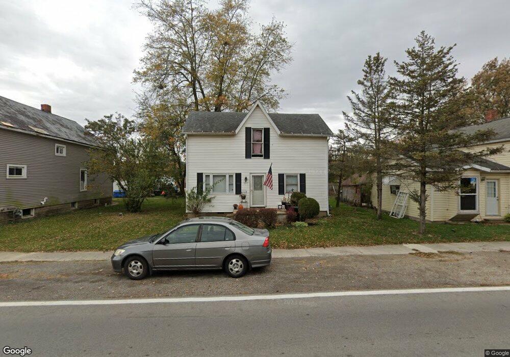
About This Home
This home is located at 207 N Front St, Alger, OH 45812 and is currently estimated at $96,864, approximately $67 per square foot. 207 N Front St is a home located in Hardin County with nearby schools including Upper Scioto Valley Elementary School, Upper Scioto Valley Middle School, and Upper Scioto Valley High School.
Ownership History
Date
Name
Owned For
Owner Type
Purchase Details
Closed on
Feb 20, 2018
Sold by
Tummel Robert
Bought by
Mcclure Mark A
Current Estimated Value
Purchase Details
Closed on
Apr 23, 2012
Sold by
Usa Rental Fund Llc
Bought by
Tummel Robert
Purchase Details
Closed on
Feb 3, 2011
Sold by
Gossard David F
Bought by
Wells Fargo Bank Na
Purchase Details
Closed on
Jul 19, 2005
Sold by
Booher Bonnie J
Bought by
Gossard David G and Gossard Cheryl L
Home Financials for this Owner
Home Financials are based on the most recent Mortgage that was taken out on this home.
Original Mortgage
$57,600
Interest Rate
11.15%
Mortgage Type
Adjustable Rate Mortgage/ARM
Purchase Details
Closed on
Nov 29, 1994
Bought by
Booher Bonnie J and Booher Danny
Purchase Details
Closed on
Oct 19, 1987
Create a Home Valuation Report for This Property
The Home Valuation Report is an in-depth analysis detailing your home's value as well as a comparison with similar homes in the area
Home Values in the Area
Average Home Value in this Area
Purchase History
| Date | Buyer | Sale Price | Title Company |
|---|---|---|---|
| Mcclure Mark A | -- | None Available | |
| Tummel Robert | $8,500 | None Available | |
| Wells Fargo Bank Na | $74,600 | None Available | |
| Gossard David G | $44,000 | -- | |
| Booher Bonnie J | -- | -- | |
| -- | -- | -- |
Source: Public Records
Mortgage History
| Date | Status | Borrower | Loan Amount |
|---|---|---|---|
| Previous Owner | Gossard David G | $57,600 |
Source: Public Records
Tax History Compared to Growth
Tax History
| Year | Tax Paid | Tax Assessment Tax Assessment Total Assessment is a certain percentage of the fair market value that is determined by local assessors to be the total taxable value of land and additions on the property. | Land | Improvement |
|---|---|---|---|---|
| 2024 | $794 | $18,390 | $1,070 | $17,320 |
| 2023 | $799 | $18,390 | $1,070 | $17,320 |
| 2022 | $707 | $14,920 | $810 | $14,110 |
| 2021 | $740 | $14,920 | $810 | $14,110 |
| 2020 | $750 | $14,920 | $810 | $14,110 |
| 2019 | $582 | $12,200 | $770 | $11,430 |
| 2018 | $585 | $12,200 | $770 | $11,430 |
| 2017 | $1,537 | $12,200 | $770 | $11,430 |
| 2016 | $618 | $14,380 | $1,000 | $13,380 |
| 2015 | $525 | $14,380 | $1,000 | $13,380 |
| 2014 | $321 | $14,380 | $1,000 | $13,380 |
| 2013 | $1,141 | $16,440 | $1,000 | $15,440 |
Source: Public Records
Map
Nearby Homes
- 210 S Front St
- 2079 County Road 90
- 8083 County Road 35
- 3115 County Road 80
- 2864 Ohio 309
- 3931 County Road 80
- 6782 County Road 15
- 407 Marion St Unit 403
- 752 County Road 60
- 4071 Township Road 35
- 803 Union St
- 221 S Oak St
- 523 S Simon St
- 200 S Main St
- 21 Unit Real Estate Package
- 314 E University Ave
- 301 S Main St
- 314 S Simon St
- 308-310 S Simon St
- !dnp! 700 College