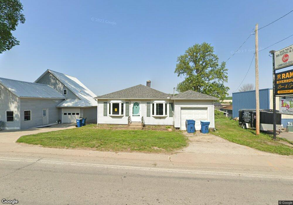
207 N High St Port Byron, IL 61275
Estimated Value: $98,000 - $149,000
--
Bed
--
Bath
816
Sq Ft
$153/Sq Ft
Est. Value
About This Home
This home is located at 207 N High St, Port Byron, IL 61275 and is currently estimated at $124,822, approximately $152 per square foot. 207 N High St is a home located in Rock Island County with nearby schools including Riverdale Elementary School, Riverdale Middle School, and Riverdale Senior High School.
Ownership History
Date
Name
Owned For
Owner Type
Purchase Details
Closed on
Oct 13, 2023
Sold by
First Financial Group Llc
Bought by
Case Robert Willam
Current Estimated Value
Home Financials for this Owner
Home Financials are based on the most recent Mortgage that was taken out on this home.
Original Mortgage
$88,000
Outstanding Balance
$59,332
Interest Rate
7.43%
Mortgage Type
New Conventional
Estimated Equity
$65,490
Create a Home Valuation Report for This Property
The Home Valuation Report is an in-depth analysis detailing your home's value as well as a comparison with similar homes in the area
Home Values in the Area
Average Home Value in this Area
Purchase History
| Date | Buyer | Sale Price | Title Company |
|---|---|---|---|
| Case Robert Willam | $62,000 | None Listed On Document |
Source: Public Records
Mortgage History
| Date | Status | Borrower | Loan Amount |
|---|---|---|---|
| Open | Case Robert Willam | $88,000 |
Source: Public Records
Tax History Compared to Growth
Tax History
| Year | Tax Paid | Tax Assessment Tax Assessment Total Assessment is a certain percentage of the fair market value that is determined by local assessors to be the total taxable value of land and additions on the property. | Land | Improvement |
|---|---|---|---|---|
| 2024 | $2,059 | $27,142 | $8,567 | $18,575 |
| 2023 | $2,059 | $24,901 | $7,860 | $17,041 |
| 2022 | $1,397 | $23,749 | $7,496 | $16,253 |
| 2021 | $1,828 | $22,511 | $7,105 | $15,406 |
| 2020 | $1,314 | $22,178 | $7,000 | $15,178 |
| 2019 | $1,318 | $22,178 | $7,000 | $15,178 |
| 2018 | $1,670 | $26,870 | $5,462 | $21,408 |
| 2017 | $2,118 | $26,870 | $5,462 | $21,408 |
| 2016 | $1,624 | $26,499 | $5,387 | $21,112 |
| 2015 | $2,021 | $25,271 | $5,137 | $20,134 |
| 2014 | $309 | $24,775 | $5,036 | $19,739 |
| 2013 | $309 | $24,775 | $5,036 | $19,739 |
Source: Public Records
Map
Nearby Homes
- 205 N High St
- 107 Hickory St
- 210 N High St
- 202 Walnut St
- 236 N Main St
- 236 N Main St Unit 2
- 208 N Main St
- 301 N High St
- 212 N High St
- 103 Hickory St
- 204 Walnut St
- 104 Hickory St
- 110 N High St
- 302 N Main St
- 305 N High St
- 209 N Main St
- 304 N Main St
- 215 N Main St
- 215 N Main St Unit 215
- 215 N Main St Unit 219