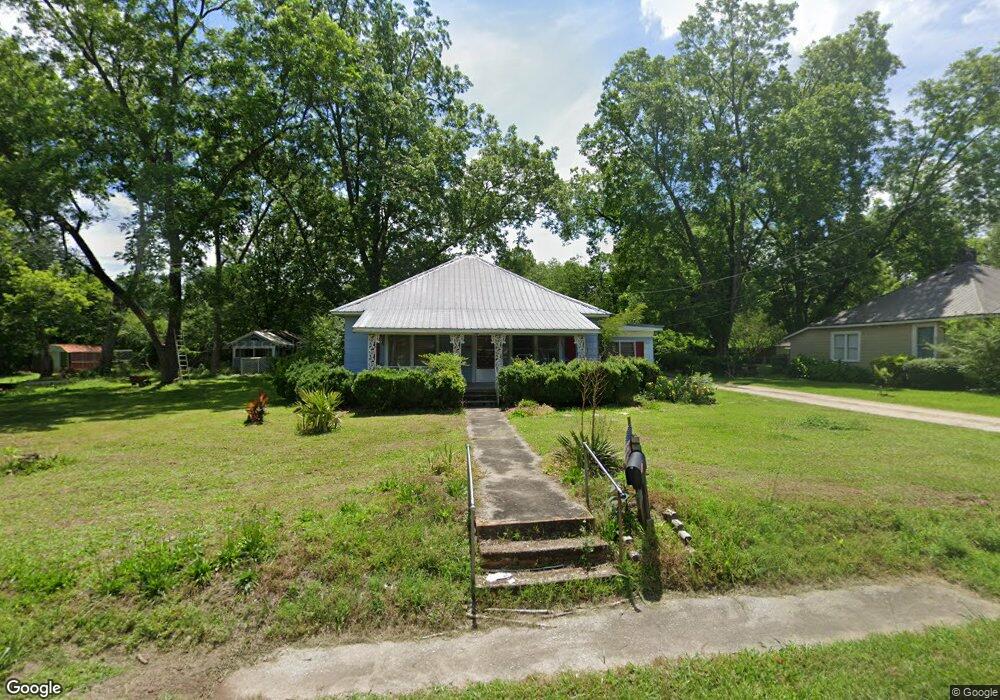
207 N Hilliard St Union Point, GA 30669
Estimated Value: $83,000 - $200,000
3
Beds
2
Baths
1,024
Sq Ft
$133/Sq Ft
Est. Value
About This Home
This home is located at 207 N Hilliard St, Union Point, GA 30669 and is currently estimated at $136,480, approximately $133 per square foot. 207 N Hilliard St is a home located in Greene County with nearby schools including Greene County High School.
Ownership History
Date
Name
Owned For
Owner Type
Purchase Details
Closed on
Jul 25, 2025
Sold by
Barnhart Lisa Napier
Bought by
Davis Ellen and Barnhart William Jamie
Current Estimated Value
Purchase Details
Closed on
Jan 1, 1977
Sold by
Smith Leroy
Bought by
Barnhart Kelsey
Purchase Details
Closed on
Jan 1, 1964
Sold by
Barnhart Kelsey
Bought by
Carter Julia A Est
Purchase Details
Closed on
Jan 1, 1949
Sold by
Farmers Home Adm
Bought by
Barnhart Kelsey
Create a Home Valuation Report for This Property
The Home Valuation Report is an in-depth analysis detailing your home's value as well as a comparison with similar homes in the area
Home Values in the Area
Average Home Value in this Area
Purchase History
| Date | Buyer | Sale Price | Title Company |
|---|---|---|---|
| Davis Ellen | -- | -- | |
| Barnhart Kelsey | -- | -- | |
| Smith Leroy | -- | -- | |
| Carter Julia A Est | -- | -- | |
| Barnhart Kelsey | -- | -- |
Source: Public Records
Tax History Compared to Growth
Tax History
| Year | Tax Paid | Tax Assessment Tax Assessment Total Assessment is a certain percentage of the fair market value that is determined by local assessors to be the total taxable value of land and additions on the property. | Land | Improvement |
|---|---|---|---|---|
| 2024 | $785 | $24,680 | $3,960 | $20,720 |
| 2023 | $598 | $23,800 | $3,960 | $19,840 |
| 2022 | $556 | $22,280 | $3,960 | $18,320 |
| 2021 | $541 | $20,440 | $3,960 | $16,480 |
| 2020 | $380 | $10,680 | $3,360 | $7,320 |
| 2019 | $389 | $10,680 | $3,360 | $7,320 |
| 2018 | $251 | $10,680 | $3,360 | $7,320 |
| 2017 | $349 | $10,729 | $3,375 | $7,354 |
| 2016 | $358 | $10,973 | $3,375 | $7,598 |
| 2015 | $328 | $10,973 | $3,375 | $7,598 |
| 2014 | $347 | $11,660 | $3,375 | $8,284 |
Source: Public Records
Map
Nearby Homes
- 112 Hendry St
- 202 Veazey St
- 0 Woodland Ct Unit 10543600
- 324 N Rhodes St
- 1041 Hillcrest Dr
- 215 Hunter St
- 1241 Old Siloam Rd
- 0 S Rhodes St Unit 10618488
- 5401 Union Point Hwy
- 0 Washington Hwy Unit 7276060
- 1860 Washington Hwy
- 1201 Buffalo Lick Rd
- 0 Buffalo Lick Rd Unit 10551234
- 0 Buffalo Lick Rd Unit 10551325
- 1581 Highway 77 S
- 1581 Highway 77 S Hwy
- 1251 Adams Rd
- 1251 Brick House Rd
- 1251 Brickhouse Rd
- 0 Old Union Point Rd Unit 1 10557753
- 205 N Hillard St
- 205 N Hilliard St
- 206 Ray St
- 204 Ray St
- 206 N Hilliard St
- 202 Ray St
- 300 Crawfordville Rd
- 205 Hart Ave
- 203 Crawfordville Rd
- 207 Hart Ave
- 201 Hart Ave
- 205 Crawfordville Rd
- 302 Crawfordville Rd
- 303 Hart Ave
- 203 Ray St
- 203 Newsome St
- 109 Hart Ave
- 207 Newsome St
- 113 Crawfordville Rd
- 204 Hart Ave